Hunterdon County is a county located in the western section of the U.S. state of New Jersey. As of the 2019 Census estimate, the county's population was 124,371, making it the state's 18th-most populous county, representing a 3.1% decrease from the 128,349 enumerated in the 2010 United States Census, in turn increasing by 6,360 (+5.2%) from the 121,989 counted in the 2000 Census. Its county seat is Flemington.
Route 12 is a state highway located in Hunterdon County, New Jersey, United States. It runs 11.69 mi (18.81 km) from the Uhlerstown–Frenchtown Bridge at the Delaware River border with Pennsylvania in Frenchtown east to an intersection with U.S. Route 202 and Route 31 at the Flemington Circle in Flemington. The route is mostly a two-lane undivided road that passes through rural areas of woodland and farmland. It intersects Route 29 and County Route 513 in Frenchtown, CR 519 in Kingwood Township, CR 579 on the border of Delaware Township and Raritan Township, and CR 523 in Raritan Township.
Route 31 is a state highway in New Jersey, United States. It runs 48.93 mi (78.75 km) from U.S. Route 1 Business /US 206 in Trenton, Mercer County, north to an intersection with US 46 in Buttzville in White Township, Warren County. Along the way, Route 31 heads through the communities of Flemington, Clinton and Washington. Most of the highway is state-maintained; however, the section within the city limits of Trenton is maintained by the city. Much of Route 31 is a two-lane highway that passes through farmland, woodland, and mountainous areas. Two portions of the route—from Trenton to Pennington and from Ringoes to Clinton—consist of more development.

Flemington is a borough in Hunterdon County, New Jersey, United States. It is the county seat of Hunterdon County. As of the 2010 United States Census, the borough's population was 4,581, reflecting an increase of 381 (+9.1%) from the 4,200 counted in the 2000 Census, which had in turn increased by 153 (+3.8%) from the 4,047 counted in the 1990 Census. Most of the borough is located in the Amwell Valley and the Raritan Valley. Northwestern portions of the borough sit on the Hunterdon Plateau.

High Bridge is a borough in Hunterdon County, New Jersey, United States. As of the 2010 United States Census, the borough's population was 3,648, reflecting a decline of 128 (-3.4%) from the 3,776 counted in the 2000 Census, which had in turn declined by 110 (-2.8%) from the 3,886 counted in the 1990 Census.

Raritan Township is a township in Hunterdon County, New Jersey, United States. As of the 2010 United States Census, the township's population was 22,185, reflecting an increase of 2,376 (+12.0%) from the 19,809 counted in the 2000 Census, which had in turn increased by 4,193 (+26.9%) from the 15,616 counted in the 1990 Census. The township is located within the heart of the Amwell Valley and Raritan Valley regions, as the South Branch of the Raritan River flows through the center of the township. The northwestern portion of the township is located on the Hunterdon Plateau.

Readington Township is a township located in the easternmost portion of Hunterdon County, New Jersey, United States. As of the 2010 United States Census, the township's population was 16,126, reflecting an increase of 323 (+2.0%) from the 15,803 counted in the 2000 Census, which had in turn increased by 2,403 (+17.9%) from the 13,400 counted in the 1990 Census.

Stockton is a borough in Hunterdon County, New Jersey, United States. The borough sits on the Delaware River at the western end of Amwell Valley. As of the 2010 United States Census, the borough's population was 538, reflecting a decline of 22 (-3.9%) from the 560 counted in the 2000 Census, which had in turn declined by 69 (-11.0%) from the 629 counted in the 1990 Census.

The South Branch Raritan River is a 50-mile-long (80 km) tributary of the Raritan River in central New Jersey in the United States.
The Readington Township Public Schools is a community public school district that serves students in pre-kindergarten through eighth grade from Readington Township, in Hunterdon County, New Jersey, United States.
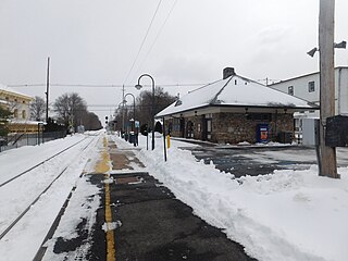
White House is a NJ Transit railroad station on the Raritan Valley Line, in the Whitehouse Station section of Readington in Hunterdon County, New Jersey. The station is on the west side of Main Street in the center and the station building has subsequently been turned into a branch library for the Hunterdon County Library system. This station has limited weekday service and no weekend service.
The Delaware Township School District is a community public school district that serves students in pre-kindergarten through eighth grade from Delaware Township, in Hunterdon County, New Jersey, United States.
Readington Village is an unincorporated community located within Readington Township in Hunterdon County, New Jersey, United States, that is centered on the converging of Readington Road, Hillcrest Road, Centerville Road and Brookview Road. It is located on Holland Brook, originally named Amanmechunk, which means large creek in the Unami dialect. The area was inhabited by the Raritan prior to the arrival of European settlers. The Native Americans who lived near Readington Village travelled to the coast during the summer for fish and clams. Such a trip is mentioned in an Indian deed transferring lands around Holland Brook to English and Dutch settlers. The deed mentions two of the natives, who lived at Readington: Metamisco and Wataminian.

Three Bridges is an unincorporated community located within Readington Township in Hunterdon County, New Jersey, United States, on the South Branch Raritan River. It is named for the three original bridges which crossed the river.
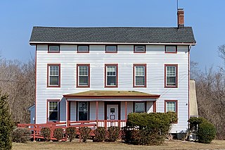
Darts Mills is a historic unincorporated community located within Readington Township in Hunterdon County, New Jersey, United States. It is located on the South Branch of the Raritan River, and several mills were built there in the early 18th century. At its height, a merchant, blacksmith, store and complex of mills were here. The last mill at this site burnt down in 1994. Foundation walls and a mill race remain at the site today. On April 29, 1982, Dart's Mill was added to the National Register of Historic Places.

Flemington Junction is an unincorporated community located within Raritan Township in Hunterdon County, New Jersey, United States. The area is located approximately one and a half miles (2.4 km) northeast of downtown Flemington and was the site of the junction of the Lehigh Valley Railroad's Flemington Branch and Mainline. The Flemington Junction station was listed as part of the Raritan–Readington South Branch Historic District in 1990. Today, the Flemington Spur tracks have been removed but numerous industries and commercial businesses are located in the vicinity of the crossing. In addition to the Norfolk Southern rail line, County Route 523 passes through the area.

McCrea Mills is an unincorporated community located within Readington Township in Hunterdon County, New Jersey, United States.

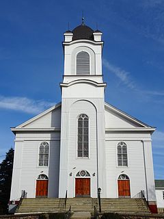
The Readington Reformed Church is a historic church located at 124 Readington Road, Readington Village, an unincorporated community located within Readington Township in Hunterdon County, New Jersey. It was known in colonial times as the Dutch Reformed Church of North Branch. It is the oldest Dutch Reformed Church in the county. The current building was built in 1865. The churchyard is known as the Readington Reformed Church Cemetery. The church was added as a contributing property of the Readington Village Historic District by the National Register of Historic Places on June 24, 1991.
The Raritan–Readington South Branch Historic District is a 556-acre (225 ha) historic district along River Road from New Jersey Route 31 to U.S. Route 202 near Flemington in Hunterdon County, New Jersey. It is primarly on the western side of the South Branch Raritan River in Raritan Township. It extends onto the eastern side of the river in Readington Township. County Route 523 and County Route 612 pass through the district to the north. The district encompasses the small settlements of Holcomb Mills, Flemington Junction, and Rockefellows Mills. It was added to the National Register of Historic Places on January 26, 1990, for its significance in architecture, politics, transportation, and exploration/settlement. The district includes 36 contributing buildings, four contributing structures, and three contributing sites. It also includes the John Reading Farmstead, previously listed on the NRHP individually.

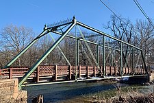
The Rockafellows Mill Bridge is a one-lane Pratt thru truss bridge that carries Rockafellows Mill Road over the South Branch Raritan River in Rockefellows Mills, Hunterdon County, New Jersey. The bridge was added to the National Register of Historic Places on January 26, 1990 as part of the Raritan–Readington South Branch Historic District.