Perryville may refer to a location in the United States:

Perryville is a town in Cecil County, Maryland, United States. The population was 4,361 at the 2010 census. The town is located near an access for Interstate 95, on the north side of the outlet of the Susquehanna River.

Nanuet is a train station in Nanuet, New York, serving Metro-North Railroad and NJ Transit trains on the Pascack Valley Line. Its official address is 1 Prospect Street, but in reality, it is located on Orchard Street West, diagonally off the southwest corner of Prospect Street and Middletown Road.

Franklin Park is an unincorporated community and census-designated place (CDP) located within Franklin Township, in Somerset County, New Jersey, United States. As of the 2010 United States Census, the CDP's population was 13,295. Route 27 bisects the village and serves as the dividing line between the two counties. The adjacent sections of South Brunswick and North Brunswick, Middlesex County on the east side of Route 27 are also known as Franklin Park, but are not included within the CDP's boundaries.

West Trenton is a section of Ewing Township in Mercer County, New Jersey, United States. It is a suburban area located adjacent to the northwestern portion of the city of Trenton, from which it derives its name. Located at the intersection of Bear Tavern Road/Grand Avenue and West Upper Ferry Road, it is one of the oldest settlements in Ewing Township.

Lalbazar is a neighbourhood in Central Kolkata, earlier known as Calcutta, in the Indian state of West Bengal. It is part of the central business district adjoining B.B.D. Bagh area. The headquarters of the Kolkata Police is located here and is popularly known by the same name.

Whitehouse, also spelled White House, is an unincorporated community located within Readington Township in Hunterdon County, New Jersey. The community lies along the former Jersey Turnpike, just west of Mechanicsville. The Whitehouse–Mechanicsville Historic District, which includes historic places in both Whitehouse and Mechanicsville, was added to the National Register of Historic Places on March 17, 2015.

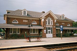
Perryville is a passenger rail station in Perryville, Maryland, served by MARC's Penn Line. The station is located on the southern part of the Northeast Corridor, between the Newark, DE and Aberdeen, MD stations. Although Amtrak does not regularly serve the station, a single Amtrak train—Northeast RegionalNo. 111—stops at Perryville to board MARC ticket holders traveling south. The station is also the northernmost in the MARC system and the terminus for the Penn Line.

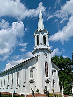
Liberty Corner is an unincorporated community located in Bernards Township, in Somerset County, New Jersey, United States. Liberty Corner is about 3.75 miles (6 km) south of Bernardsville. Liberty Corner has a post office with ZIP code 07938. The Liberty Corner Historic District was listed on the state and national registers of historic places in 1991.

State Hill is a rather large and sparsely populated unincorporated community in Lower Heidelberg Township, Pennsylvania, in Berks County. The area that is now State Hill was once called Lorah, Pennsylvania. This was named for the first settler within the village's boundary. At one time, the main road through the unincorporated community was called Dry Road. It received the name for lack of water to tap into for wells. This road is now known as Brownsville Road. The village started out as just a few cabins, but by the mid-1800s had built a Tavern. It was called Dry Tavern, named after the road it was on. The village has a great view of Blue Marsh Lake along Brownsville Rd. It is also home to an extinct elementary school, Lower Heidelberg Consolidated School, which ran from 1931 to 2006. It is served by the academically prestigious Wilson School District. State Hill also has several businesses, including Berks Western Telecom, Ganly's Pub and Deli, Blue Marsh Taxidermy, a Western Berks Fire Department station, and the Lower Heidelberg Township Police and Municipal building. Ganly's was built in 1993. It was built where The Beer Garden Tavern used to be located.

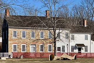
Rodgers Tavern, also known as Stevenson's Tavern, is a historic hotel located at Perryville, Cecil County, Maryland, United States. It is a mid-18th-century, two-story stone structure with a basement. All rooms have corner fireplaces. It was frequently visited by George Washington between the years 1755 and 1798, when it was owned and operated as an inn and tavern by Colonel John Rodgers (1728–1791). He was the father of John Rodgers (1772–1838), U.S. naval officer. During the 1880s the house was divided into two halves, east and west.

Potterstown is an unincorporated community along the border of Clinton and Readington townships in Hunterdon County, New Jersey.

The Sourlands is a region in the US state of New Jersey that includes portions of Hunterdon County, Mercer County and Somerset County. It is centered on Sourland Mountain and comprises parts of Lambertville, East Amwell, West Amwell, Hillsborough, Hopewell Boro, Hopewell Township, and Montgomery Township. The region is flanked by the Hopewell Fault to the south and Amwell Valley to the north that runs from Mount Airy to an area just west of Flagtown and a diabase formation running from Lambertville to Mount Airy. The Sourland also include a hilly area towards the southwest called Pleasant Valley, with a number of farms. Although much of the Sourlands is not conducive to farming, Pleasant Valley and the slopes on the surrounding ridges have a number of farms. The slopes of the ridge to the north are also home to Unionville Vineyard.

The Stage House Inn is located in Scotch Plains, Union County, New Jersey, United States. The inn was built in 1737 and was added to the National Register of Historic Places on April 15, 1982.

Arneytown is an unincorporated community located along Province Line Road on the border of North Hanover Township in Burlington County and Upper Freehold Township in Monmouth County of New Jersey. It is two miles (3.2 km) north of Jacobstown. Province Line Road was on the boundary line between the Provinces of East Jersey and West Jersey. The area was once called Upper Freehold by 18th-century Quaker settlers. With the establishment of the first post office in 1827, it became known as Arneytown.

Waterloo is an unincorporated community located in Howard County in the U.S. state of Maryland. Located at the intersection of Waterloo Road and Washington Boulevard, the neighborhood is encompassed mostly by Jessup and partially by Elkridge.

Van Syckel is an unincorporated community located within Union Township in Hunterdon County, New Jersey. The Van Syckel Corner District was listed on the National Register of Historic Places in 1979.

The Perryville Tavern, also known as the Perryville Inn, is a historic building at 167 Perryville Road in Perryville, Union Township, Hunterdon County, New Jersey. It was added to the National Register of Historic Places on July 15, 1977 for its significance in architecture and commerce. The tavern is located west of Clinton, south of the intersection of Interstate 78 and Perryville Road.

Old Bridge, also known as the Historic Village of Old Bridge, is an unincorporated community located within East Brunswick in Middlesex County, New Jersey. It is on the South River, a tributary of the Raritan River. The community is named after the first bridge built here to cross the river, the South River Bridge. After other bridges were built crossing the river, it became known as the Old Bridge. The Old Bridge Historic District, encompassing much of the village, is listed on the state and national registers of historic places.

Mechlin's Corner Tavern, also known as Peter Mechling's Corner Tavern, is a historic building located at the intersection of County Route 625 and County Route 579 in the Mechlings Corner, New Jersey section of Union Township, Hunterdon County, New Jersey and near Pittstown. It was added to the National Register of Historic Places on November 1, 1974, for its significance in architecture and commerce.


