
Readington Township is a township located in the easternmost portion of Hunterdon County, in the U.S. state of New Jersey. As of the 2020 United States census, the township's population was 16,128, an increase of two people (+0.0%) from the 2010 census count of 16,126, which in turn reflected an increase of 323 (+2.0%) from the 15,803 counted in the 2000 census.

Whitehouse, also spelled White House, is an unincorporated community located within Readington Township in Hunterdon County, New Jersey. The community lies along the former Jersey Turnpike, just west of Mechanicsville. The Whitehouse–Mechanicsville Historic District, which includes historic places in both Whitehouse and Mechanicsville, was added to the National Register of Historic Places on March 17, 2015.
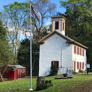
Readington Village is an unincorporated community located within Readington Township in Hunterdon County, in the U.S. state of New Jersey, that is centered on the converging of Readington Road, Hillcrest Road, Centerville Road and Brookview Road. It is located on Holland Brook, originally named Amanmechunk, which means large creek in the Unami dialect. The area was inhabited by the Raritan prior to the arrival of European settlers. The Native Americans who lived near Readington Village travelled to the coast during the summer for fish and clams. Such a trip is mentioned in an Indian deed transferring lands around Holland Brook to George Willocks, an East and West New Jersey Proprietor. The deed mentions two of the natives, who lived at Readington: Metamisco and Wataminian.
Potterstown is an unincorporated community along the border of Clinton and Readington townships in Hunterdon County, New Jersey.

Little York is an unincorporated community located along the border of Alexandria and Holland townships in Hunterdon County, in the U.S. state of New Jersey. Little York is located on County Route 614 3.1 miles (5.0 km) north-northeast of Milford. Little York has a post office with ZIP Code 08834.
Mount Pleasant is an unincorporated community located along County Route 519 on the border of Alexandria Township and Holland Township, in Hunterdon County, New Jersey. The Mount Pleasant Historic District was listed on the National Register of Historic Places in 1987.

Readingsburg, also known as Stone Mill, is an unincorporated community located along the South Branch Raritan River within Clinton Township in Hunterdon County, New Jersey.

Pleasant Valley is an unincorporated community located within Hopewell Township in Mercer County, in the U.S. state of New Jersey. The Howell Living History Farm, also known as the Joseph Phillips Farm, is located in the community.
Amsterdam is an unincorporated community located within Holland Township in Hunterdon County, in the U.S. state of New Jersey. Located on the southern flank of the Musconetcong Mountain, the area was settled in the first half of the 18th century. It was later named after Amsterdam, Netherlands. The Amsterdam Historic District, encompassing the community, was listed on the state and national registers of historic places in 1995.

Rockefellows Mills is an unincorporated community located within Raritan Township in Hunterdon County, in the U.S. state of New Jersey. The settlement is located along the South Branch Raritan River near Three Bridges. The river is spanned in the area by the historic Rockafellows Mill Bridge built in 1900 and part of the Raritan–Readington South Branch Historic District. Most of the area within the Raritan Township side of the river is forested however on the north side of the river in Readington Township, some farmland dots the area.

Sand Brook is an unincorporated community located along County Route 523, Sand Brook-Headquarters & Britton Roads in Delaware Township in Hunterdon County, in the U.S. state of New Jersey.

Mount Airy is an unincorporated community located within West Amwell Township in Hunterdon County, in the U.S. state of New Jersey.
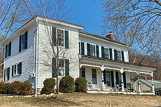
The New Hampton Historic District is a 76-acre (31 ha) historic district in the village of New Hampton in Lebanon Township in Hunterdon County, New Jersey, United States. The district was added to the National Register of Historic Places on April 6, 1998, for its significance in architecture, commerce, education, transportation, and community development from c. 1780 to 1929. It includes 42 contributing buildings, six contributing sites, and four contributing structures located along Musconetcong River Road.

Headquarters is an unincorporated community located within the Amwell Valley of Delaware Township in Hunterdon County, New Jersey. The settlement is centered around the intersection of Zentek Road and County Route 604. It is about 3 miles (4.8 km) from Ringoes to the east and 1 mile (1.6 km) from Sergeantsville to the west. The Headquarters Historic District was listed on the state and national registers of historic places in 2011 and had its boundary increased in 2016.

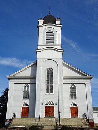
The Whitehouse–Mechanicsville Historic District is a historic district located along old New Jersey Route 28, Mill, Lamington and School Roads in Whitehouse and Mechanicsville, unincorporated communities in Readington Township, Hunterdon County, New Jersey. It was added to the National Register of Historic Places on March 17, 2015 for its significance in architecture and community development. The district includes 140 contributing buildings.

The Asbury Historic District is a 288-acre (117 ha) historic district encompassing the community of Asbury in Franklin Township of Warren County, New Jersey. It is bounded by County Route 632, County Route 643, Maple Avenue, Kitchen Road, and School Street and extends along the Musconetcong River into Bethlehem Township of Hunterdon County. It was listed on the National Register of Historic Places on March 19, 1993 for its significance in architecture, industry, religion, community development, politics/government, and commerce. The district includes 141 contributing buildings, a contributing structure, two contributing sites, and four contributing objects.

The Covered Bridge Historic District, in Delaware Township, Hunterdon County, New Jersey, is a 97-acre (39 ha) historic district along County Route 604, Pine Hill Road, and Lower Creek Road. It was listed on the National Register of Historic Places on March 5, 1999, for its significance in architecture, settlement, and transportation. The listing included seven contributing buildings, two contributing structures, and three contributing sites.

Taylor's Mill Historic District, a 26-acre (11 ha) historic district featuring the gristmill Taylor's Mill, is located along Taylor's Mill Road and Rockaway Road near Oldwick in Readington Township, Hunterdon County, New Jersey. It was added to the National Register of Historic Places on June 11, 1992 for its significance in architecture, exploration/settlement, industry, and military. The district boundary was increased by 8 acres (3.2 ha) in 1997 to cross the Rockaway Creek and extend into Tewksbury Township.

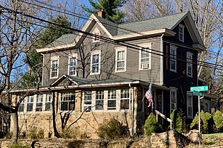
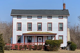
The Charles Eversole House, also known as the Eversole-Hall House, is a historic house located at 509 County Road 523 near Whitehouse Station in Readington Township, Hunterdon County, New Jersey. It was added to the National Register of Historic Places on February 1, 2006, for its significance in architecture. The house was purchased by the township in 1988 for use as a museum, which opened in 1991.
The Raritan–Readington South Branch Historic District is a 556-acre (225 ha) historic district along River Road from New Jersey Route 31 to U.S. Route 202 near Flemington in Hunterdon County, New Jersey. It is primarily on the western side of the South Branch Raritan River in Raritan Township. It extends onto the eastern side of the river in Readington Township. County Route 523 and County Route 612 pass through the district to the north. The district encompasses the small settlements of Holcomb Mills, Flemington Junction, and Rockefellows Mills. It was added to the National Register of Historic Places on January 26, 1990, for its significance in architecture, politics, transportation, and exploration/settlement. The district includes 36 contributing buildings, four contributing structures, and three contributing sites. It also includes the John Reading Farmstead, previously listed on the NRHP individually.


