Snydertown, New Jersey

Last updated

Snydertown, New Jersey
110 Snydertown Road, Snydertown, NJ.jpg
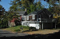
Former grist mill on Snydertown Road
Location map of Hunterdon County, New Jersey.svg
Red pog.svg
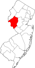
Snydertown
Location of Snydertown in Hunterdon County Inset: Location of county within the state of New Jersey
USA New Jersey location map.svg
Red pog.svg
Snydertown
Snydertown (New Jersey)
Usa edcp location map.svg
Red pog.svg
Snydertown
Snydertown (the United States)
Coordinates: 40°23′55″N74°50′02″W / 40.39861°N 74.83389°W / 40.39861; -74.83389
Country Flag of the United States.svg  United States
State Flag of New Jersey.svg  New Jersey
County Hunterdon
Township East Amwell
Elevation
[1]
318 ft (97 m)
GNIS feature ID880676 [1]

Snydertown is an unincorporated community located within East Amwell Township in Hunterdon County, in the U.S. state of New Jersey. [2] The settlement is located on the southern face of Sourland Mountain at the intersection of Linvale Road and Snydertown Road. [3] In the past, a mill operated in Snydertown. [4] [5]

Contents

Historic district

The New Market–Linvale–Snydertown Historic District encompassing the community was added to the National Register of Historic Places in 1998 for its significance in architecture, commerce, settlement, and community development. [6] [7]

At the intersection of Linvale Road and Snydertown Road Snydertown, NJ.jpg
At the intersection of Linvale Road and Snydertown Road

Related Research Articles

<span class="mw-page-title-main">East Amwell Township, New Jersey</span> Township in Hunterdon County, New Jersey, United States

East Amwell Township is a township in Hunterdon County, in the U.S. state of New Jersey. As of the 2020 United States census, the township's population was 3,917, a decrease of 96 (−2.4%) from the 2010 census count of 4,013, which in turn reflected a decline of 442 (−9.9%) from the 4,455 counted in the 2000 census.

<span class="mw-page-title-main">Raritan Township, New Jersey</span> Township in Hunterdon County, New Jersey, United States

Raritan Township is a township in Hunterdon County, in the U.S. state of New Jersey. As of the 2020 United States census, the township's population was 23,447, an increase of 1,262 (+5.7%) from the 2010 census count of 22,185, which in turn reflected an increase of 2,376 (+12.0%) from the 19,809 counted in the 2000 census. The township is located within the heart of the Amwell Valley and Raritan Valley regions, as the South Branch of the Raritan River flows through the center of the township. The northwestern portion of the township is located on the Hunterdon Plateau.

<span class="mw-page-title-main">West Amwell Township, New Jersey</span> Township in Hunterdon County, New Jersey, United States

West Amwell Township is a township in Hunterdon County, in the U.S. state of New Jersey. As of the 2020 United States census, the township's population was 3,005, a decrease of 835 (−21.7%) from the 2010 census count of 3,840, which in turn reflected an increase of 1,457 (+61.1%) from the 2,383 counted in the 2000 census.

<span class="mw-page-title-main">Ringoes, New Jersey</span> Place in Hunterdon County, New Jersey, US

Ringoes is an unincorporated community and census-designated place (CDP) located within East Amwell Township in Hunterdon County, in the U.S. state of New Jersey. The community is served by the United States Postal Service as ZIP Code 08551 and as of the 2020 United States census, the CDP's population was 849.

<span class="mw-page-title-main">Pittstown, New Jersey</span> Place in Hunterdon County, New Jersey, United States

Pittstown is an unincorporated community located at the intersection of the boundaries of Alexandria, Franklin and Union townships in Hunterdon County, New Jersey. The area is named after William Pitt. The area is served as United States Postal Service ZIP Code 08867. The area was named Hofftown in the 18th century after landowner Lawrence Hoff. The Pittstown Historic District was listed on the state and national registers of historic places in 1990.

<span class="mw-page-title-main">The Sourlands</span>

The Sourlands is a region in the central portion of the U.S. state of New Jersey that includes portions of Hunterdon County, Mercer County, and Somerset County. It is centered on Sourland Mountain and comprises parts of Lambertville, East Amwell, West Amwell, Hillsborough, Hopewell Boro, Hopewell Township, and Montgomery Township. The region is flanked by the Hopewell Fault to the south and Amwell Valley to the north that runs from Mount Airy to an area just west of Flagtown and a diabase formation running from Lambertville to Mount Airy. The Sourland also include a hilly area towards the southwest called Pleasant Valley, with a number of farms. Although much of the Sourlands is not conducive to farming, Pleasant Valley and the slopes on the surrounding ridges have a number of farms. The slopes of the ridge to the north are also home to Unionville Vineyard.

<span class="mw-page-title-main">Rosemont, Hunterdon County, New Jersey</span> Place in Hunterdon County, New Jersey, United States

Rosemont is an unincorporated community located within Delaware Township in Hunterdon County, in the U.S. state of New Jersey. Its ZIP code is 08556. Located at the top of a small hill, the center of the community is located along Kingwood Stockton Road near its intersections with Raven Rock Rosemont Road and Rosemont Ringoes Road. Farmland and residences make up the surrounding area while the center of the settlement includes residences, a post office, and an antique shop.

<span class="mw-page-title-main">Little York, Hunterdon County, New Jersey</span> Populated place in Hunterdon County, New Jersey, US

Little York is an unincorporated community located along the border of Alexandria and Holland townships in Hunterdon County, in the U.S. state of New Jersey. Little York is located on County Route 614 3.1 miles (5.0 km) north-northeast of Milford. Little York has a post office with ZIP Code 08834.

<span class="mw-page-title-main">Mount Pleasant, Hunterdon County, New Jersey</span> Populated place in Hunterdon County, New Jersey, US

Mount Pleasant is an unincorporated community located along County Route 519 on the border of Alexandria Township and Holland Township, in Hunterdon County, New Jersey. The Mount Pleasant Historic District was listed on the National Register of Historic Places in 1987.

<span class="mw-page-title-main">Readingsburg, New Jersey</span> Populated place in Hunterdon County, New Jersey, US

Readingsburg, also known as Stone Mill, is an unincorporated community located along the South Branch Raritan River within Clinton Township in Hunterdon County, New Jersey.

<span class="mw-page-title-main">Pleasant Valley, Mercer County, New Jersey</span> Populated place in Mercer County, New Jersey, US

Pleasant Valley is an unincorporated community located within Hopewell Township in Mercer County, in the U.S. state of New Jersey. The Howell Living History Farm, also known as the Joseph Phillips Farm, is located in the community.

<span class="mw-page-title-main">Amsterdam, New Jersey</span> Populated place in Hunterdon County, New Jersey, US

Amsterdam is an unincorporated community located within Holland Township in Hunterdon County, in the U.S. state of New Jersey. Located on the southern flank of the Musconetcong Mountain, the area was settled in the first half of the 18th century. It was later named after Amsterdam, Netherlands. The Amsterdam Historic District, encompassing the community, was listed on the state and national registers of historic places in 1995.

<span class="mw-page-title-main">Cloverhill, New Jersey</span> Populated place in Hunterdon and Somerset counties, New Jersey, US

Cloverhill is an unincorporated community located at the intersection of the boundaries of East Amwell and Raritan townships in Hunterdon County and Hillsborough Township in Somerset County, in the U.S. state of New Jersey. The Clover Hill Historic District was listed on the state and national registers of historic places in 1980.

<span class="mw-page-title-main">Linvale, New Jersey</span> Unincorporated community in New Jersey, United States

Linvale is an unincorporated community located along the border of East Amwell and West Amwell townships in Hunterdon County, New Jersey, United States. The community was historically known as New Market.

<span class="mw-page-title-main">Reaville, New Jersey</span> Populated place in Hunterdon County, New Jersey, US

Reaville is an unincorporated community located along the border of East Amwell and Raritan townships in Hunterdon County, New Jersey. By the 1830s, it was known as Greenville. It was later renamed after Runkle Rea, the first postmaster in 1850.

<span class="mw-page-title-main">Rockefellows Mills, New Jersey</span> Populated place in Hunterdon County, New Jersey, US

Rockefellows Mills is an unincorporated community located within Raritan Township in Hunterdon County, in the U.S. state of New Jersey. The settlement is located along the South Branch Raritan River near Three Bridges. The river is spanned in the area by the historic Rockafellows Mill Bridge built in 1900 and part of the Raritan–Readington South Branch Historic District. Most of the area within the Raritan Township side of the river is forested however on the north side of the river in Readington Township, some farmland dots the area.

<span class="mw-page-title-main">Mount Airy, New Jersey</span> Populated place in Hunterdon County, New Jersey, US

Mount Airy is an unincorporated community located within West Amwell Township in Hunterdon County, in the U.S. state of New Jersey.

<span class="mw-page-title-main">Wertsville, New Jersey</span> Populated place in Hunterdon County, New Jersey, US

Wertsville is an unincorporated community located along County Route 602 in East Amwell Township of Hunterdon County, in the U.S. state of New Jersey.

<span class="mw-page-title-main">Headquarters, New Jersey</span> Populated place in Hunterdon County, New Jersey, US

Headquarters is an unincorporated community located within the Amwell Valley of Delaware Township in Hunterdon County, New Jersey. The settlement is centered around the intersection of Zentek Road and County Route 604. It is about 3 miles (4.8 km) from Ringoes to the east and 1 mile (1.6 km) from Sergeantsville to the west. The Headquarters Historic District was listed on the state and national registers of historic places in 2011 and had its boundary increased in 2016.

<span class="mw-page-title-main">New Market–Linvale–Snydertown Historic District</span> United States historic place

The New Market–Linvale–Snydertown Historic District is a 160-acre (65 ha) historic district located along NJ 31, Linvale, Snydertown, and Woodsville Roads in the communities of Linvale, formerly known as New Market, and Snydertown in the townships of East Amwell and West Amwell in Hunterdon County, New Jersey, United States. It was added to the National Register of Historic Places on February 12, 1998, for its significance in architecture, commerce, settlement, and community development. The district includes 33 contributing buildings, four contributing structures, and one contributing object.

References

  1. 1 2 "Snydertown". Geographic Names Information System . United States Geological Survey, United States Department of the Interior.
  2. Locality Search, State of New Jersey. Accessed January 31, 2015.
  3. Google (June 21, 2016). "Aerial view of Snydertown" (Map). Google Maps . Google. Retrieved June 21, 2016.
  4. Snell, James P. (1881). History of Hunterdon and Somerset Counties, New Jersey. Philadelphia: Everts & Peck. p.  366 . Retrieved June 21, 2016. snydertown.
  5. "Historic Photos". East Amwell Historical Society. Retrieved June 21, 2016.
  6. "National Register Information System  (#98000097)". National Register of Historic Places . National Park Service. November 2, 2013.
  7. Bertland, Dennis N. (June 1997). "National Register of Historic Places Inventory/Nomination: New Market–Linvale–Snydertown Historic District". National Park Service. With accompanying 26 photos