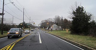
Route 31 is a state highway in New Jersey, United States. It runs 48.93 mi (78.75 km) from U.S. Route 1 Business /US 206 in Trenton, Mercer County, north to an intersection with US 46 in Buttzville in White Township, Warren County. Along the way, Route 31 heads through the communities of Flemington, Clinton and Washington. Most of the highway is state-maintained; however, the section within the city limits of Trenton is maintained by the city. Much of Route 31 is a two-lane highway that passes through farmland, woodland, and mountainous areas. Two portions of the route—from Trenton to Pennington and from Ringoes to Clinton—consist of more development.

Readington Township is a township located in the easternmost portion of Hunterdon County, New Jersey, United States. As of the 2010 United States Census, the township's population was 16,126, reflecting an increase of 323 (+2.0%) from the 15,803 counted in the 2000 Census, which had in turn increased by 2,403 (+17.9%) from the 13,400 counted in the 1990 Census.
County Route 523, abbreviated CR 523, is a county highway in the U.S. state of New Jersey. The highway extends 29.55 miles (47.56 km) from Route 29 in Stockton to U.S. Route 202 (US 202) in Bedminster Township.

Pittstown is an unincorporated community located at the intersection of the boundaries of Alexandria, Franklin and Union townships in Hunterdon County, New Jersey, United States. The area is named after William Pitt. The area is served as United States Postal Service ZIP Code 08867. The area was named Hofftown in the 18th century after landowner Lawrence Hoff.
Pleasant Plains is an unincorporated community and census-designated place (CDP) located in Franklin Township, in Somerset County, New Jersey, United States. As of the 2010 United States Census, the CDP's population was 922. Having no distinct boundaries, a large area in the center of Franklin Township centered on the intersections of South Middlebush Road with Claremont and Suydam Roads is generally considered Pleasant Plains.

Holland Brook is a tributary of the South Branch Raritan River in Hunterdon and Somerset Counties, New Jersey in the United States.

Whitehouse is an unincorporated community located within Readington Township in Hunterdon County, New Jersey, United States. The community lies along the Jersey Turnpike, just west of Mechanicsville.
Old York Road is a roadway that was built in the 18th century to connect Philadelphia with New York City. Through New Jersey it was built along the Raritan "Naraticong Trail", also known as the Tuckaraming Trail. A memorial plaque to the friendship of the Naraticong Indians, who permitted the road to be built over their trail, sits at the intersection of Old York Road and Canal in Raritan, NJ. The Swift Sure Stage Coach Line completed the journey between the two cities in two days and cost only a few dollars.
Dreahook Creek is a left tributary of Holland Brook in Readington, New Jersey. It begins on township owned land near Creek Road and Dreahook Road. It merges with another small tributary on the east side of County Route 620 before entering the Holland Brook. It was named after the former Dutch village of Dreahook (Drea-Hook). The name is a corruption of Driehoek, which is the Dutch word for triangle. It was likely named for the triangle created by the settlement in its relation to the early roads to Flemington, Whitehouse Station, Readington Village and Pleasant Run, which have since been rerouted.
Readington Village is an unincorporated community located within Readington Township in Hunterdon County, New Jersey, United States, that is centered on the converging of Readington Road, Hillcrest Road, Centerville Road and Brookview Road. It is located on Holland Brook, originally named Amanmechunk, which means large creek in the Unami dialect. The area was inhabited by the Raritan prior to the arrival of European settlers. The Native Americans who lived near Readington Village travelled to the coast during the summer for fish and clams. Such a trip is mentioned in an Indian deed transferring lands around Holland Brook to English and Dutch settlers. The deed mentions two of the natives, who lived at Readington: Metamisco and Wataminian.

Stanton is an unincorporated community located within Readington Township in Hunterdon County, New Jersey, United States. The community dates back to the 17th century and was settled by the Dutch. It was originally called Housel's after Johannes Housel, who had a farmstead along Dreahook Road in the mid-18th century. After the death of William Housel, the last owner of the Housel farmstead, it then carried the name of Waggoner's Hill after landowner William Waggoner. The community took the descriptive name of Mount Pleasant during the beginning of the 20th century and would finally become known as Stanton to distinguish it from another Mount Pleasant. The name "Stanton" was taken from James Logan's Pennsylvania estate: Stenton, which in turn is named for the Scottish village where his father was born. Logan was a proprietor of West Jersey, a mayor of Philadelphia, and a Chief Justice of the Supreme Court of Pennsylvania. Logan Way in Readington is named after him, as well as Logan Circle and the Logan neighborhood in Philadelphia and Logan Township in Clinton County, Pennsylvania. In the 1830s, a Reformed Church and a general store were built, both of which are present today.

Potterstown is an unincorporated community along the border of Clinton and Readington townships in Hunterdon County, New Jersey, United States. Potterstown once was home to taverns, a blacksmith, a store house, a wheelwright and a pottery shop which gave the hamlet its name. It is along an old Raritan Path and on the Jersey Turnpike. Aray Van Guinea, a free African-American, donated land for the construction of the German Lutheran Church. Robert Livingston, James Alexander, his son Lord Stirling and John Stevens all owned land here at some time. John Taylor, an officer with the Hunterdon 4th Militia built a house and mill, which was used during the Revolutionary War to provide soldiers with food. Taylor's Mill has plans to become the fourth Readington Museum.

Pleasant Run was a hamlet in Readington Township, Hunterdon County, New Jersey, United States. Located along Campbell's Brook, the hamlet consisted of farms, a schoolhouse and a general store. The brook was named after John Campbell, who purchased the land around it in 1685.
Rowland's Mills or Rowland Mills is an unincorporated community located on the western edge of Readington Township in Hunterdon County, New Jersey, United States. In 1760, a gristmill was erected at this site, followed by a sawmill around the time of the American Revolutionary War. A hamlet grew up around the mill complex in the early 19th century along the road connecting Flemington and Clinton. In 1838, Rynear Rowland (1798-1862), whom the village was later named after, purchased the mills. At its peak the settlement had a store, a blacksmith shop owned by Oliver Hart Ewing and numerous houses. In the later part of the 19th century the community diminished in size and was all but abandoned in the 1920s when the road through it was widened and designated as State Route 30, the predecessor of modern New Jersey Route 31.

Three Bridges is an unincorporated community located within Readington Township in Hunterdon County, New Jersey, United States, on the South Branch Raritan River. It is named for the three original bridges which crossed the river.
Barley Sheaf was an unincorporated community located within Readington Township in Hunterdon County, New Jersey, United States. It was named for the grain once grown in the region. The hamlet was on Barley Sheaf Road between County Route 629 (CR 629) and CR 523. The hamlet at one time housed a general store, a post office, blacksmith, creamery, a hotel and numerous farmsteads. Today only farms remain of the hamlet. The hamlet also carried the names of Farmersville and Campbellsville after Catherine Campbell, who ran the hotel in the area.

Ackors Corner is an unincorporated community located within Hopewell Township in Mercer County, New Jersey, United States. The settlement is located at the intersection of Bear Tavern Road / Trenton-Harbourton Road, Pennington-Harbourton Road and Pleasant Valley Road. It is named for the Ackors family which owned land near the current intersection. Small residences and farmland make up the area surrounding Ackors Corner but the area rises in elevation from east to west as one approaches Baldpate Mountain, part of the Sourland Mountain range.

Centerville was a hamlet within Readington Township in Hunterdon County, New Jersey, United States. The community was located along Campbell's Brook and Old York Road. Centerville grew up because of a tavern that marked the halfway point on the long Swift Sure Stage Line route from New York to Philadelphia. The hamlet had a school, a store, a post office, a church and blacksmith. When the railroads and newer roads were built, Centerville saw few visitors and today all the buildings there are residences.

Rockefellows Mills is an unincorporated community located within Raritan Township in Hunterdon County, New Jersey, United States. The settlement is located along the South Branch Raritan River near Three Bridges. The river is spanned in the area by a 1910-constructed Pratt through truss bridge. Most of the area within the Raritan Township side of the river is forested however on the north side of the river in Readington Township, some farmland dots the area.
Holland is an unincorporated community located on the border of Holmdel and Middletown townships in Monmouth County, New Jersey, United States. The community is centered on the intersection of County Route 52 and Holland Road. The area making up Holland is hilly and consists of large single-family residences. An AT&T Labs campus is located off Laurel Avenue while Tatum County Park is also located in the area, both of which are on the Middletown side of the border.


