
The New Jersey Department of Transportation (NJDOT) is the agency responsible for transportation issues and policy in New Jersey, such as maintaining and operating the State's highway and public road system, planning and developing transportation policy and assisting with rail, freight and intermodal transportation issues. It is headed by the Commissioner of Transportation. The present Commissioner is Diane Gutierrez-Scaccetti.

The Eagleswood Military Academy was a private military academy in Perth Amboy, in Middlesex County, New Jersey, United States, which served antebellum educational needs.
The Central Delaware Valley AVA is an American Viticultural Area located in southeastern Pennsylvania and New Jersey. The wine appellation includes 96,000 acres (38,850 ha) surrounding the Delaware River north of Philadelphia. Its southern boundary is near Titusville, New Jersey, just north of Trenton, and its northern border is near Musconetcong Mountain. A variety of Vitis vinifera and Vitis labrusca grape varieties can be grown in the area. It has a hot-summer humid continental climate (Dfa) and is in hardiness zones 6b and 7a.
Stephen Dilts is a former Commissioner of the New Jersey Department of Transportation (NJDOT), having been sworn into the post on December 16, 2008 and leaving that position early in 2010. Dilts succeeded Kris Kolluri, who was shifted to head the $12.5 billion New Jersey Schools Development Authority.

Locust Corner is an unincorporated community located within East Windsor Township in Mercer County, New Jersey, United States. The corner itself refers to the intersection of Princeton-Hightstown Road, County Route 571, and Old Trenton Road, CR 535. To the southeast of the intersection is the western terminus of the Hightstown Bypass, New Jersey Route 133. Much of the area has developed into commercial office spaces including on what was once the site of RCA Astro Electronics' headquarters.

Ackors Corner is an unincorporated community located within Hopewell Township in Mercer County, New Jersey, United States. The settlement is located at the intersection of Bear Tavern Road / Trenton-Harbourton Road, Pennington-Harbourton Road and Pleasant Valley Road. It is named for the Ackors family which owned land near the current intersection. Small residences and farmland make up the area surrounding Ackors Corner but the area rises in elevation from east to west as one approaches Baldpate Mountain, part of the Sourland Mountain range.

Allens Corner is an unincorporated community located within Franklin Township in Hunterdon County, New Jersey, United States.
Scrappy Corner is an unincorporated community located along the border of Lebanon Township in Hunterdon County and Washington Township in Morris County, New Jersey, United States.

Berdines Corner or Berdines Corners is an unincorporated community located within North Brunswick Township in Middlesex County, New Jersey, United States.

Cooleys Corner is an unincorporated community located within Upper Freehold Township in Monmouth County, New Jersey, United States. The site of the settlement is within the Assunpink Wildlife Management Area, a New Jersey Department of Environmental Protection Division of Fish and Wildlife-operated preserved area in Monmouth and Mercer counties along the Assunpink Creek. Before the creation of the Assunpink Lake in the 1970s, the area consisted of farmland located at the intersection of Clarksburg Road and Imlaystown-Hightstown Road. Some farmland is still present in the area but is now mostly used by hunters. The main boat ramp to Assunpink Lake is located along the former Imlaystown-Hightstown Road.
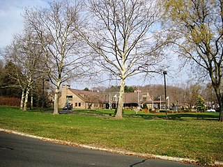
Crawford Corners or Crawfords Corner is an unincorporated community located within Holmdel Township in Monmouth County, New Jersey, United States. The settlement is located at the intersection of Holmdel Road and Crawfords Corners Road in the hilly northern portion of the township. The settlement is located about one-half mile (0.80 km) from Crawford Hill, the highest point in Monmouth County. The area also includes the township's town hall, police department, and high school in addition to a New Jersey State Police barracks and the PNC Bank Arts Center off the Garden State Parkway. These buildings and landmarks comprise the eastern section of the settlement, homes and heavily treed lands are located on the west side of Holmdel Road, and Holmdel Park makes up the southern portion of the area.

Dogs Corners is an unincorporated community in Ocean Township in Monmouth County, New Jersey, United States.

Herberts Corner is an unincorporated community located within Marlboro Township in Monmouth County, New Jersey, United States. The center of the community is located at the intersection of Wyncrest Road and Newman Springs Road.

Shacks Corner is an unincorporated community located within Howell Township in Monmouth County, New Jersey, United States. The settlement is located along New Jersey Route 33 at its intersection with Yellow Brook Road. The area to the north of Route 33 is forested and consists entirely of Naval Weapons Station Earle. On the south side of the highway, there are small clusters of homes along Yellow Brook Road and a few other side roads off Route 33. Some businesses also line the southern side of Route 33 in the area.

Smocks Corner or Smocks Corners is an unincorporated community located within Marlboro Township in Monmouth County, New Jersey, United States. Located at the intersection of Pleasant Valley Road and Conover Road, the area is mostly residences with some open space and farmland. It was called "Smocks Corner" because the Smock Family had houses in that area, both sides of the street back in the 1700s.
Tiltons Corner or Tiltons Corners is an unincorporated community located where the municipal boundaries of Keansburg Borough, Hazlet Township and Middletown Township intersect in Monmouth County, New Jersey, United States.

Coxs Corner, also known as Cox's Corner or Wrightsville, is an unincorporated community located within Upper Freehold Township, in Monmouth County, New Jersey, United States. Named for congressman and brigadier general James Cox (1753–1810), who had lived here at the family home of "Box Grove", it is at the juncture of County Route 524 and County Route 43. The Upper Freehold Historic Farmland Byway passes through the area.
Van Marters Corner or Van Mariners Corners is an unincorporated community located along the border of Union Beach Borough and Hazlet Township in Monmouth County, New Jersey, United States.

Wertheins Corner is an unincorporated community located within Ocean Township in Monmouth County, New Jersey, United States. The settlement is centered on the intersection of New Jersey Route 35 and Deal Road in the center part of the township. Commercial businesses line Route 35 through the area. On the west side of Route 35, there are some apartment and townhouse complexes while single-family houses are located on the east side of the highway.
Wileys Corner or Wileys Corners is an unincorporated community located within Tinton Falls in Monmouth County, New Jersey, United States.


