The Pittstown Historic District is a historic district along Pittstown Road and adjacent portions of Race Street and Quakertown Road, encompassing the village. It was added to the National Register of Historic Places on October 11, 1990 for its significance in agriculture, architecture, settlement, industry, transportation, and military history. It includes 79 contributing buildings.[9]
Sites of interest
The Pittstown Barn is a barn built in 1800[10] across from the intersection of CR 579 and Pittstown Road. The south side of the barn has: "So this is Pittstown" painted on it with "R U Lost" and an old county map underneath.
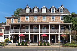
The Pittstown Inn was originally Hoff's Mill. The building, which served as a tavern and informal town hall, was also a stagecoach stopover and place of lodging. The building went through several owners and was later known as the Century Hotel when owned by Moore Furman, before suffering a fire which greatly damaged the interior.[5]
The Refine Spa (Furman's Mill) was built as a stone grist mill along the on a tributary of Capoolong Creek by Moore Furman, quartermaster general of George Washington's army.[11]
Notable people
People who were born in, residents of, or otherwise closely associated with Pittstown include:
No Interstate, U.S. or State routes pass through. Only major roads, such as CR 513, CR 519 and CR 579 (which only runs along the northeast border), pass through Alexandria Township.
↑A Brief History, Township of Franklin. Accessed May 5, 2023. "Villages and hamlets in Franklin are Cherryville (Dogtown until 1856), Quakertown (sometimes called Fairview between 1834 and 1856) and Pittstown (Hoffs until the late 1700s), which also is partly in Alexandria and Union Townships."
↑Cosdon, Christina K. "Kappler lands 2nd Invitational", St. Petersburg Times, March 30, 2003. Accessed August 12, 2007. "Kappler, 36, of Pittstown, N.J., bested a field of eight Saturday night in the jumpoff and was the only one to complete two fault-free rounds with his Dutch-bred Royal Kaliber."
↑Obituary of Frank P. Muehlheuser Jr., Martin Funeral Home. Accessed June 29, 2020. "Frank P. Muehlheuser Jr. - 79, of the Pittstown Section of Alexandria Twp., NJ died Saturday, April 22nd at home."
This page is based on this Wikipedia article Text is available under the CC BY-SA 4.0 license; additional terms may apply. Images, videos and audio are available under their respective licenses.