Annandale, New Jersey | |
---|---|
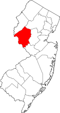
Location in Hunterdon County Location in New Jersey | |
Coordinates: 40°38′49″N74°53′17″W / 40.646838°N 74.888177°W | |
Country | United States |
State | New Jersey |
County | Hunterdon |
Township | Clinton |
Area | |
• Total | 1.45 sq mi (3.76 km2) |
• Land | 1.45 sq mi (3.76 km2) |
• Water | 0.00 sq mi (0.00 km2) 0.00% |
Elevation | 423 ft (129 m) |
Population (2020) | |
• Total | 1,663 |
• Density | 1,146.90/sq mi (442.85/km2) |
Time zone | UTC−05:00 (Eastern (EST)) |
• Summer (DST) | UTC−04:00 (Eastern (EDT)) |
ZIP Code | |
Area code | 908 |
FIPS code | 34-01480 [5] [6] [7] |
GNIS feature ID | 02389137 [5] [8] |
Annandale is an unincorporated community and census-designated place (CDP) [9] located within Clinton Township, in Hunterdon County, in the U.S. state of New Jersey. [10] As of the 2010 United States Census, the CDP's population was 1,695. [11] The Annandale Historic District was listed on the state and national registers of historic places in 1994.
According to the United States Census Bureau, Annandale had a total area of 1.452 square miles (3.76 km2), all of which was land. [5] [12] It has a hot-summer humid continental climate (Dfa) and average monthly temperatures range from 28.2 °F in January to 72.9 °F in July. [13] The hardiness zone is 6b.
Census | Pop. | Note | %± |
---|---|---|---|
1990 | 1,074 | — | |
2000 | 1,276 | 18.8% | |
2010 | 1,695 | 32.8% | |
2020 | 1,663 | −1.9% | |
Population sources: 2000 [14] 2010 [11] |
The 2010 United States census counted 1,695 people, 658 households, and 455 families in the CDP. The population density was 1,167.6 people per square mile (450.8 people/km2). There were 692 housing units at an average density of 476.7 units per square mile (184.1 units/km2). The racial makeup was 86.61% (1,468) White, 2.48% (42) Black or African American, 0.35% (6) Native American, 7.32% (124) Asian, 0.00% (0) Pacific Islander, 0.77% (13) from other races, and 2.48% (42) from two or more races. Hispanic or Latino of any race were 4.66% (79) of the population. [11]
Of the 658 households, 38.8% had children under the age of 18; 56.4% were married couples living together; 9.6% had a female householder with no husband present and 30.9% were non-families. Of all households, 25.2% were made up of individuals and 7.8% had someone living alone who was 65 years of age or older. The average household size was 2.58 and the average family size was 3.15. [11]
27.7% of the population were under the age of 18, 5.7% from 18 to 24, 27.3% from 25 to 44, 31.3% from 45 to 64, and 8.1% who were 65 years of age or older. The median age was 39.1 years. For every 100 females, the population had 92.2 males. For every 100 females ages 18 and older there were 94.3 males. [11]
As of the 2000 United States census [6] there were 1,276 people, 451 households, and 354 families living in the CDP. The population density was 339.8 people/km2 (880 people/sq mi). There were 472 housing units at an average density of 125.7 units/km2 (326 units/sq mi). The racial makeup of the CDP was 96.47% White, 0.63% African American, 2.19% Asian, 0.63% from other races, and 0.08% from two or more races. Hispanic or Latino of any race were 1.72% of the population. [14]
There were 451 households, out of which 43.2% had children under the age of 18 living with them, 68.7% were married couples living together, 6.7% had a female householder with no husband present, and 21.5% were non-families. 16.4% of all households were made up of individuals, and 7.5% had someone living alone who was 65 years of age or older. The average household size was 2.83 and the average family size was 3.23. [14]
In the CDP the population was spread out, with 29.0% under the age of 18, 4.7% from 18 to 24, 32.1% from 25 to 44, 25.7% from 45 to 64, and 8.5% who were 65 years of age or older. The median age was 38 years. For every 100 females, there were 96.9 males. For every 100 females age 18 and over, there were 97.4 males. [14]
The median income for a household in the CDP was $80,738, and the median income for a family was $104,009. Males had a median income of $65,814 versus $37,171 for females. The per capita income for the CDP was $30,176. None of the families and 1.0% of the population were living below the poverty line, including no under eighteens and 8.0% of those over 64. [14]
Annandale Historic District | |
Location | Roughly bounded by Maple Avenue, Main Street, Beaver Avenue and East Street |
---|---|
Area | less than one acre |
Built | 1852 |
Architectural style | Italianate, Queen Anne, Colonial Revival |
NRHP reference No. | 94001108 [15] |
NJRHP No. | 1574 [16] |
Significant dates | |
Added to NRHP | September 8, 1994 |
Designated NJRHP | August 1, 1994 |
The Annandale Historic District is a historic district encompassing the village of Annandale. The district was added to the National Register of Historic Places on September 8, 1994, for its significance in architecture, commerce, and industry from 1852 to 1930. It includes 191 contributing buildings. [17]
Immaculate Conception School (PreK-8) operates under the supervision of Roman Catholic Diocese of Metuchen. [18]
People who were born in, residents of, or otherwise closely associated with Annandale include:
Collings Lakes is an unincorporated community and census-designated place (CDP) located within Buena Vista Township in Atlantic County, in the U.S. state of New Jersey. As of the 2010 United States Census, the CDP's population was 1,706.
Moorestown-Lenola is an unincorporated community and census-designated place (CDP) located within Moorestown Township in Burlington County, in the U.S. state of New Jersey. As of the 2010 United States Census, the CDP's population was 14,217.
Pemberton Heights is an unincorporated community and census-designated place (CDP) located within Pemberton Township, in Burlington County, in the U.S. state of New Jersey. As of the 2010 United States Census, the CDP's population was 2,423.
Presidential Lakes Estates is an unincorporated community and census-designated place (CDP) located within Pemberton Township, in Burlington County, in the U.S. state of New Jersey. As of the 2010 United States Census, the CDP's population was 2,365.
Greentree is an unincorporated community and census-designated place (CDP) located within Cherry Hill Township, in Camden County, in the U.S. state of New Jersey. As of the 2010 United States Census, the CDP's population was 11,367.
Oak Valley is an unincorporated community and census-designated place (CDP) located within Deptford Township in Gloucester County, in the U.S. state of New Jersey. As of the 2010 U.S. census, Oak Valley's population was 3,483.
Whitehouse Station, also spelled White House Station, is an unincorporated community and census-designated place (CDP) located within Readington Township, in Hunterdon County, New Jersey. At the 2010 United States Census, the CDP's population was 2,089. Whitehouse Station takes its name from Whitehouse and Abraham Van Horne's 18th century tavern.
Fords is a census-designated place (CDP) located within Woodbridge Township, in Middlesex County, in the U.S. state of New Jersey. As of the 2010 United States Census, the CDP's population was 15,187.
Kingston is an unincorporated community and census designated place (CDP) along the border of South Brunswick Township in Middlesex County and Franklin Township in Somerset County, and also located relatively near Princeton in Mercer County in the U.S. state of New Jersey. The historic settlement is in the Raritan Valley region, located along the course of the Millstone River. As of the 2010 United States Census, the CDP's population was 1,493, of which 1,222 were in South Brunswick Township and 271 in Franklin Township.
Plainsboro Center is an unincorporated community and census-designated place (CDP) located within Plainsboro Township, situated in southern Middlesex County, within the U.S. state of New Jersey. As of the 2020 United States census, the CDP's population was 2,760, its highest decennial count ever and an increase of 48 (+1.8%) from the 2,712 recorded at the 2010 census, which in turn reflected an increase of 503 (+22.8%) from the 2,209 counted in the 2000 census.
Port Reading is an unincorporated community and census-designated place (CDP) located within Woodbridge Township, in Middlesex County, in the U.S. state of New Jersey. As of the 2010 U.S. census, Port Reading's population was 3,728.
Princeton Meadows is an unincorporated community and census-designated place (CDP) located within Plainsboro Township, in Middlesex County, in the U.S. state of New Jersey. As of the 2010 United States Census, the CDP's population was 13,834.
White Meadow Lake is an unincorporated community and census-designated place (CDP) located within Rockaway Township, in Morris County, in the U.S. state of New Jersey. As of the 2010 United States Census, the CDP's population was 8,836.
Cedar Glen Lakes is an unincorporated community and census-designated place (CDP) located within Manchester Township, in Ocean County, in the U.S. state of New Jersey. As of the 2010 United States Census, the CDP's population was 1,421.
Dover Beaches North is an unincorporated community and census-designated place (CDP) located within Toms River, in Ocean County, in the U.S. state of New Jersey. As of the 2010 United States Census, the CDP's population was 1,239. The CDP includes the communities of Ocean Beaches 1, 2 and 3, Chadwick Beach, Chadwick Island, Seacrest Beach, Monterey Beach, Silver Beach, Normandy Shores and half of Normandy Beach. Dover Beaches North is situated on the Barnegat Peninsula, a long, narrow barrier peninsula that separates Barnegat Bay from the Atlantic Ocean.
Holiday City-Berkeley is an unincorporated community and census-designated place (CDP) located within Berkeley Township, in Ocean County, in the U.S. state of New Jersey. As of the 2010 United States Census, the CDP's population was 13,884.
Toms River is an unincorporated community and census-designated place (CDP) located within and constituting the mainland portion of Toms River Township, in Ocean County, in the U.S. state of New Jersey. As of the 2020 United States census, the CDP's population was 92,830, its highest decennial count ever and an increase of 4,039 (+4.5%) from the 88,791 recorded at the 2010 census, which in turn reflected an increase of 2,464 (+2.9%) from the 86,327 counted in the 2000 census. The Toms River CDP is the county seat of Ocean County. The area is named for Toms River, whose estuary flows through the community and empties into Barnegat Bay.
Beattystown is an unincorporated community and census-designated place (CDP) located within Mansfield Township, in Warren County, in the U.S. state of New Jersey. As of the 2010 United States Census, the CDP's population was 4,554.
Lakewood is an unincorporated community and census-designated place (CDP) located within Lakewood Township, in Ocean County, in the U.S. state of New Jersey. As of the 2010 United States Census, the CDP's population was 53,805.
Elwood is an unincorporated community and census-designated place (CDP) located within Mullica Township in Atlantic County, in the U.S. state of New Jersey. As of the 2010 United States Census, the CDP's population was 1,437. At previous censuses, the area was listed by the U.S. Census Bureau as the Elwood-Magnolia CDP. The area is served as United States Postal Service ZIP Code 08217.