
Bethlehem Township is a township in Hunterdon County, in the U.S. state of New Jersey. It is part of the New York metropolitan area. As of the 2020 United States census, the township's population was 3,745, a decrease of 234 (−5.9%) from the 2010 census count of 3,979, which in turn reflected an increase of 159 (+4.2%) from the 3,820 counted in the 2000 census.
Califon is a borough in Hunterdon County, in the U.S. state of New Jersey. As of the 2020 United States census, the borough's population was 1,005, a decrease of 71 (−6.6%) from the 2010 census count of 1,076, which in turn reflected an increase of 21 (+2.0%) from the 1,055 counted in the 2000 census.

Clinton is a town in Hunterdon County, in the U.S. state of New Jersey. It is located on the South Branch of the Raritan River in the Raritan Valley region. As of the 2020 United States census, the town's population was 2,773, an increase of 54 (+2.0%) from the 2010 census count of 2,719, which in turn reflected an increase of 87 (+3.3%) from the 2,632 counted in the 2000 census. Despite its relatively small population, Clinton is the predominant control city for Interstate 78 traveling westbound from Newark.
Delaware Township is a township in Hunterdon County, in the U.S. state of New Jersey. Part of the township is on the Hunterdon Plateau, while the southern portions are in the Amwell Valley. As of the 2020 United States census, the township's population was 4,560, a decrease of three people (−0.1%) from the 2010 census count of 4,563, which in turn reflected an increase of 85 (+1.9%) from the 4,478 counted in the 2000 census.

Franklin Township is a township in central Hunterdon County, in the U.S. state of New Jersey. As of the 2020 United States census, the township's population was 3,267, an increase of 72 (+2.3%) from the 2010 census count of 3,195, which in turn reflected an increase of 205 (+6.9%) from the 2,990 counted in the 2000 census. Most of the township lies on the Hunterdon Plateau with only the eastern section along the South Branch Raritan River being on the lower part of the Newark Basin.

Lebanon is a borough in Hunterdon County, in the U.S. state of New Jersey. As of the 2020 United States census, the borough's population was 1,665, the highest ever in any decennial census and an increase of 307 (+22.6%) from the 2010 census count of 1,358, which in turn reflected an increase of 293 (+27.5%) from the 1,065 counted in the 2000 census.

Readington Township is a township located in the easternmost portion of Hunterdon County, in the U.S. state of New Jersey. As of the 2020 United States census, the township's population was 16,128, an increase of two people (+0.0%) from the 2010 census count of 16,126, which in turn reflected an increase of 323 (+2.0%) from the 15,803 counted in the 2000 census.

West Amwell Township is a township in Hunterdon County, in the U.S. state of New Jersey. As of the 2020 United States census, the township's population was 3,005, a decrease of 835 (−21.7%) from the 2010 census count of 3,840, which in turn reflected an increase of 1,457 (+61.1%) from the 2,383 counted in the 2000 census.

Ringoes is an unincorporated community and census-designated place (CDP) located within East Amwell Township in Hunterdon County, in the U.S. state of New Jersey. The community is served by the United States Postal Service as ZIP Code 08551 and as of the 2020 United States census, the CDP's population was 849.

Pittstown is an unincorporated community located at the intersection of the boundaries of Alexandria, Franklin and Union townships in Hunterdon County, New Jersey. The area is named after William Pitt. The area is served as United States Postal Service ZIP Code 08867. The area was named Hofftown in the 18th century after landowner Lawrence Hoff. The Pittstown Historic District was listed on the state and national registers of historic places in 1990.
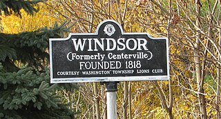
Windsor is a small historic unincorporated community and census-designated place (CDP) located within Robbinsville Township in Mercer County, in the U.S. state of New Jersey. The area is served as United States Postal Service ZIP Code 08561. As of the 2020 United States census, the CDP's population was 330, an increase of 104 (+46.0%) above the 226 counted at the 2010 census. The community, covering 570 acres (230 ha), was added to the National Register of Historic Places in 1992.

Quakertown is an unincorporated community located within Franklin Township in Hunterdon County, New Jersey. It was once known as Fairview. The area was settled by Quakers from Burlington County, who organized a meeting house here in 1733. The Quakertown Historic District was listed on the state and national registers of historic places in 1990.

Pottersville is an unincorporated community and census-designated place (CDP) split between Bedminster Township in Somerset County and Tewksbury Township in Hunterdon County, in the U.S. state of New Jersey. The area is served as United States Postal Service ZIP Code 07979. As of the 2010 United States Census, the population for ZIP Code Tabulation Area 07979 was 589. In 1990, most of the village was listed on the National Register of Historic Places as the Pottersville Village Historic District.
Uhlerstown is an unincorporated community in Tinicum Township, Bucks County, Pennsylvania, United States. The community is located along Pennsylvania Route 32 and is served by the 18920 ZIP Code.

Brookside is a historic unincorporated community and census-designated place (CDP) located within Mendham Township in Morris County, in the U.S. state of New Jersey. It is located approximately 6 mi (9.7 km) west of Morristown, the county seat.

Liberty Corner is an unincorporated community and census-designated place (CDP) located in Bernards Township, in Somerset County, in the U.S. state of New Jersey. Liberty Corner is about 3+3⁄4 miles (6.0 km) south of Bernardsville. Liberty Corner has a post office with ZIP code 07938. The Liberty Corner Historic District was listed on the state and national registers of historic places in 1991.

Stanton is an unincorporated community located within Readington Township in Hunterdon County, in the U.S. state of New Jersey. The community dates back to the 17th century and was settled by Dutch immigrants.

Little York is an unincorporated community located along the border of Alexandria and Holland townships in Hunterdon County, in the U.S. state of New Jersey. Little York is located on County Route 614 3.1 miles (5.0 km) north-northeast of Milford. Little York has a post office with ZIP Code 08834.

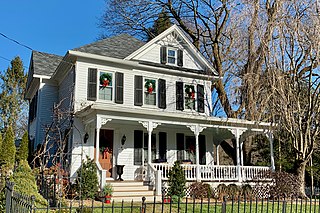
Headquarters is an unincorporated community located within the Amwell Valley of Delaware Township in Hunterdon County, New Jersey. The settlement is centered around the intersection of Zentek Road and County Route 604. It is about 3 miles (4.8 km) from Ringoes to the east and 1 mile (1.6 km) from Sergeantsville to the west. The Headquarters Historic District was listed on the state and national registers of historic places in 2011 and had its boundary increased in 2016.
Willard Harry Allen was an American poultry scientist who served as New Jersey secretary of agriculture from 1938 to 1956.


