Allerton, New Jersey | |
|---|---|
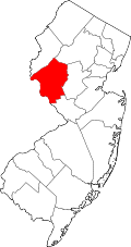
 Allerton Location in Huntredon County  Allerton Location in New Jersey  Allerton Location in the United States | |
| Coordinates: 40°36′40″N74°52′43″W / 40.61111°N 74.87861°W | |
| Country | |
| State | |
| County | Hunterdon |
| Township | Clinton |
| Elevation | 243 ft (74 m) |
| Time zone | UTC−05:00 (Eastern (EST)) |
| • Summer (DST) | UTC−04:00 (EDT) |
| GNIS feature ID | 874303 [1] |
Allerton (also known as Allerville) is an unincorporated community located within Clinton Township, in Hunterdon County, in the U.S. state of New Jersey. [1] [2] [3]
The community is centered at Route 31 and Allerton Road, 1.8 miles (2.9 km) west of the Round Valley Reservoir and 3.3 miles (5.3 km) southeast of the Spruce Run Reservoir. [4]
By 1846, Allerton had a store, steam saw mill, Baptist church, chair factory, and a few dwellings. [5]