
Route 31 is a state highway in New Jersey, United States. It runs 48.93 mi (78.75 km) from U.S. Route 1 Business /US 206 in Trenton, Mercer County, north to an intersection with US 46 in Buttzville in White Township, Warren County. Along the way, Route 31 heads through the communities of Flemington, Clinton, and Washington. Most of the highway is state-maintained; however, the section within the city limits of Trenton is maintained by the city. Much of Route 31 is a two-lane highway that passes through farmland, woodland, and mountainous areas. Two portions of the route—from Trenton to Pennington and from Ringoes to Clinton—consist of more development.

Readington Township is a township located in the easternmost portion of Hunterdon County, in the U.S. state of New Jersey. As of the 2020 United States census, the township's population was 16,128, an increase of two people (+0.0%) from the 2010 census count of 16,126, which in turn reflected an increase of 323 (+2.0%) from the 15,803 counted in the 2000 census.
The Readington Township Public Schools is a community public school district that serves students in pre-kindergarten through eighth grade from Readington Township, in Hunterdon County, New Jersey, United States.

Layton is an unincorporated community and census-designated place (CDP) located within Sandyston Township in Sussex County, in the U.S. state of New Jersey. The area is served as United States Postal Service ZIP Code 07851.
Pleasant Run may refer to the following places in the United States:
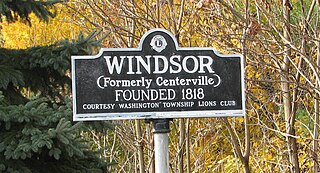
Windsor is a small historic unincorporated community and census-designated place (CDP) located within Robbinsville Township in Mercer County, in the U.S. state of New Jersey. The area is served as United States Postal Service ZIP Code 08561. As of the 2020 United States census, the CDP's population was 330, an increase of 104 (+46.0%) above the 226 counted at the 2010 census. The community, covering 570 acres (230 ha), was added to the National Register of Historic Places in 1992.

Holland Brook is a tributary of the South Branch Raritan River in Hunterdon and Somerset Counties, New Jersey in the United States.
Old York Road is a roadway that was built during the 18th century to connect Philadelphia with New York City. Through New Jersey it was built along the Raritan "Naraticong Trail", also known as the Tuckaraming Trail. A memorial plaque to the friendship of the Naraticong Indians, who permitted the road to be built over their trail, is at the intersection of Old York Road and Canal in Raritan, NJ. The Swift Sure Stage Coach Line completed the journey between the two cities in two days and cost a few dollars.
Dreahook Creek is a left tributary of Holland Brook in Readington, New Jersey. It begins on township owned land near Creek Road and Dreahook Road. It merges with another small tributary on the east side of County Route 620 before entering the Holland Brook. It was named after the former Dutch village of Dreahook (Drea-Hook). The name is a corruption of Driehoek, which is the Dutch word for triangle. It was likely named for the triangle created by the settlement in its relation to the early roads to Flemington, Whitehouse Station, Readington Village and Pleasant Run, which have since been rerouted.
Readington Village is an unincorporated community located within Readington Township in Hunterdon County, in the U.S. state of New Jersey, that is centered on the converging of Readington Road, Hillcrest Road, Centerville Road and Brookview Road. It is located on Holland Brook, originally named Amanmechunk, which means large creek in the Unami dialect. The area was inhabited by the Raritan prior to the arrival of European settlers. The Native Americans who lived near Readington Village travelled to the coast during the summer for fish and clams. Such a trip is mentioned in an Indian deed transferring lands around Holland Brook to George Willocks, an East and West New Jersey Proprietor. The deed mentions two of the natives, who lived at Readington: Metamisco and Wataminian.

Stanton is an unincorporated community located within Readington Township in Hunterdon County, in the U.S. state of New Jersey. The community dates back to the 17th century and was settled by the Dutch immigrants. It was originally called Housel's after Johannes Housel, who had a farmstead along Dreahook Road in the mid-18th century. After the death of William Housel, the last owner of the Housel farmstead, it then carried the name of Waggoner's Hill after landowner William Waggoner. The community took the descriptive name of Mount Pleasant in the early 20th century and would finally become known as Stanton to distinguish it from another Mount Pleasant. The name "Stanton" was taken from James Logan's Pennsylvania estate: Stenton, which in turn is named for the Scottish village where his father was born. Logan was a proprietor of West Jersey, a mayor of Philadelphia, and a Chief Justice of the Supreme Court of Pennsylvania. Logan Way in Readington is named after him, as well as Logan Circle and the Logan neighborhood in Philadelphia and Logan Township in Clinton County, Pennsylvania. In the 1830s, a Reformed Church and a general store were built. The Stanton Reformed Church still stands today while the Stanton General Store has been converted to an Italian restaurant called the Stanton Italian Table.
Potterstown is an unincorporated community along the border of Clinton and Readington townships in Hunterdon County, New Jersey.
Mechanicsville is an unincorporated community located within Readington Township in Hunterdon County, in the U.S. state of New Jersey. It is located along present day US Route 22, just east of Whitehouse near the intersection of Lamington Road. The hamlet once had a tavern, a store, numerous mechanic shops as well as a number of residences. As Whitehouse and Mechanicsville lost many of the businesses along the main road, the two hamlets eventually merged. The Whitehouse General Store, the East Whitehouse Fire Department and the Whitehouse United Methodist Church are in the section of Whitehouse that used to be Mechanicsville. The Ryland Inn was located in this section of Whitehouse.

Dreahook is an unincorporated community in Readington Township in Hunterdon County, in the U.S. state of New Jersey at the intersection of CR-620/Dreahook Rd and CR 523. The name is a corruption of Driehoek, which is the Dutch word for triangle. It was likely named for the triangle created by the settlement in its relation to the early roads to Flemington, Whitehouse Station, Readington Village and Pleasant Run, which have since been rerouted. Dreahook Creek and Holland Brook both pass through the area of the former village. Dreahook village once had blacksmith shop, a school and a store. Settlers farmed the land here because of the rich soil along the base of Cushetunk Mountain. There are still numerous farms in the area, including the Readington River Buffalo Farm between Dreahook and Stanton.
Pleasant Run is a tributary of the South Branch Raritan River in central New Jersey in the United States.
Pleasant Run was a hamlet in Readington Township, Hunterdon County, in the U.S. state of New Jersey. Located along Campbell's Brook, the hamlet consisted of farms, a schoolhouse and a general store. The brook was named after John Campbell, who purchased the land around it in 1685.
Rowland's Mills or Rowland Mills is an unincorporated community located on the western edge of Readington Township in Hunterdon County, in the U.S. state of New Jersey. In 1760, a gristmill was erected at this site, followed by a sawmill around the time of the American Revolutionary War. A hamlet grew up around the mill complex in the early 19th century along the road connecting Flemington and Clinton. In 1838, Rynear Rowland (1798-1862), whom the village was later named after, purchased the mills. At its peak the settlement had a store, a blacksmith shop owned by Oliver Hart Ewing and numerous houses. In the later part of the 19th century the community diminished in size and was all but abandoned in the 1920s when the road through it was widened and designated as State Route 30, the predecessor of modern New Jersey Route 31.

Three Bridges is an unincorporated community and census-designated place (CDP) located within Readington Township in Hunterdon County, in the U.S. state of New Jersey, on the South Branch Raritan River. It is named for the three original bridges which crossed the river.
Barley Sheaf was an unincorporated community located within Readington Township in Hunterdon County, New Jersey, United States. It was named for the grain once grown in the region. The hamlet was on Barley Sheaf Road between County Route 629 (CR 629) and CR 523. The hamlet at one time housed a general store, a post office, blacksmith, creamery, a hotel and numerous farmsteads. Today only farms remain of the hamlet. The hamlet also carried the names of Farmersville and Campbellsville after Catherine Campbell, who ran the hotel in the area.

Rockefellows Mills is an unincorporated community located within Raritan Township in Hunterdon County, in the U.S. state of New Jersey. The settlement is located along the South Branch Raritan River near Three Bridges. The river is spanned in the area by the historic Rockafellows Mill Bridge built in 1900 and part of the Raritan–Readington South Branch Historic District. Most of the area within the Raritan Township side of the river is forested however on the north side of the river in Readington Township, some farmland dots the area.


