
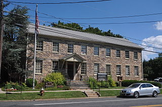
Hunterdon County is a county located in the western section of the U.S. state of New Jersey. As of the 2018 Census estimate, the county's population was 124,714, making it the state's 18th-most populous county, representing a 2.6% decrease from the 128,349 enumerated in the 2010 United States Census, in turn increasing by 6,360 (+5.2%) from the 121,989 counted in the 2000 Census. Its county seat is Flemington.
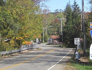
Route 12 is a state highway located in Hunterdon County, New Jersey, United States. It runs 11.69 mi (18.81 km) from the Uhlerstown–Frenchtown Bridge at the Delaware River border with Pennsylvania in Frenchtown east to an intersection with U.S. Route 202 and Route 31 at the Flemington Circle in Flemington. The route is mostly a two-lane undivided road that passes through rural areas of woodland and farmland. It intersects Route 29 and County Route 513 in Frenchtown, CR 519 in Kingwood Township, CR 579 on the border of Delaware Township and Raritan Township, and CR 523 in Raritan Township.
Delaware Township is a township in Hunterdon County, New Jersey, United States. Part of the township is on the Hunterdon Plateau, while the southern portions are in the Amwell Valley. As of the 2010 United States Census, the township's population was 4,563, reflecting an increase of 85 (+1.9%) from the 4,478 counted in the 2000 Census, which had in turn declined by 34 (-0.8%) from the 4,512 counted in the 1990 Census.
East Amwell Township is a township in Hunterdon County, New Jersey, United States. As of the 2010 United States Census, the township's population was 4,013, reflecting a decline of 442 (-9.9%) from the 4,455 counted in the 2000 Census, which had in turn increased by 123 (+2.8%) from the 4,332 counted in the 1990 Census.

Flemington is a borough in Hunterdon County, New Jersey, United States. As of the 2010 United States Census, the borough's population was 4,581, reflecting an increase of 381 (+9.1%) from the 4,200 counted in the 2000 Census, which had in turn increased by 153 (+3.8%) from the 4,047 counted in the 1990 Census. It is the county seat of Hunterdon County. Most of the borough is in the Amwell Valley, but northwest portions of the borough sit on the Hunterdon Plateau.

High Bridge is a borough in Hunterdon County, New Jersey, United States. As of the 2010 United States Census, the borough's population was 3,648, reflecting a decline of 128 (-3.4%) from the 3,776 counted in the 2000 Census, which had in turn declined by 110 (-2.8%) from the 3,886 counted in the 1990 Census.

Raritan Township is a township in Hunterdon County, New Jersey, United States. As of the 2010 United States Census, the township's population was 22,185, reflecting an increase of 2,376 (+12.0%) from the 19,809 counted in the 2000 Census, which had in turn increased by 4,193 (+26.9%) from the 15,616 counted in the 1990 Census. The southeast part of the township is in the Amwell Valley, while the northwestern part is on the Hunterdon Plateau.

Readington Township is a township located in the easternmost portion of Hunterdon County, New Jersey, United States. As of the 2010 United States Census, the township's population was 16,126, reflecting an increase of 323 (+2.0%) from the 15,803 counted in the 2000 Census, which had in turn increased by 2,403 (+17.9%) from the 13,400 counted in the 1990 Census.
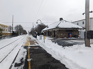
White House is a NJ Transit railroad station on the Raritan Valley Line, in the Whitehouse Station section of Readington in Hunterdon County, New Jersey, United States. The station is on the west side of Main Street in the center and the station building has subsequently been turned into a branch library for the Hunterdon County Library system. This station has limited weekday service and no weekend service.

Bartles Corner is an unincorporated community located within Raritan Township in Hunterdon County, New Jersey, United States.
Croton is an unincorporated community located along the border of Delaware and Raritan townships in Hunterdon County, New Jersey, United States. County Route 579 is the main north–south road through the area which consists of mostly forest within the Hunterdon Plateau and some houses and businesses along Route 579 and nearby New Jersey Route 12. The headwaters of the Wickecheoke Creek are located northeast of Croton before it heads downstream through the community on its way to the Delaware River.
Gary Corner is an unincorporated community located within Raritan Township in Hunterdon County, New Jersey, United States.
Larisons Corners is an unincorporated community located along the border of East Amwell and Raritan townships in Hunterdon County, New Jersey, United States. Its location is at the corner of Old York Road and where New Jersey Route 30 split from Old York Road and headed north towards Flemington. Today, Old York Road is a part of Route 179 to the southwest and County Route 514/Amwell Road northeast of the point. U.S. Route 202 and Route 31 comprise the main road to Flemington though the highway was built on a new alignment to the south of this point after US 202 bypassed Ringoes in the 1960s. A gas station and some small businesses line US 202 in the area and some churches, Larison's Corner Cemetery, and houses make up the remainder of the area.
Laurel Farms is an unincorporated community located within Tewksbury Township in Hunterdon County, New Jersey, United States.
Mechlings Corner is an unincorporated community located on the border of Alexandria and Union townships in Hunterdon County, New Jersey, United States.
Riegel Ridge is an unincorporated community located within Holland Township in Hunterdon County, New Jersey, United States.

Rockefellows Mills is an unincorporated community located within Raritan Township in Hunterdon County, New Jersey, United States. The settlement is located along the South Branch Raritan River near Three Bridges. The river is spanned in the area by a 1910-constructed Pratt through truss bridge. Most of the area within the Raritan Township side of the river is forested however on the north side of the river in Readington Township, some farmland dots the area.
Mount Lebanon is an unincorporated community located within Lebanon Township in Hunterdon County, New Jersey, United States.
Voorhees Corner is an unincorporated community located within Raritan Township in Hunterdon County, New Jersey, United States. The settlement is located at the intersection of Old York Road and Voorhees Corner Road in the eastern extents of the township. Most of the area is suburban in nature consisting of single-family houses in developments with a recreational playing field park and some farmland nearby.


