
Brownstone is a brown Triassic-Jurassic sandstone that was once a popular building material. The term is also used in the United States to refer to a townhouse clad in this, or any of a number of aesthetically similar materials.

Pittstown is an unincorporated community located at the intersection of the boundaries of Alexandria, Franklin and Union townships in Hunterdon County, New Jersey, United States. The area is named after William Pitt. The area is served as United States Postal Service ZIP Code 08867. The area was named Hofftown in the 18th century after landowner Lawrence Hoff.

Whitehouse is an unincorporated community located within Readington Township in Hunterdon County, New Jersey, United States. The community lies along the Jersey Turnpike, just west of Mechanicsville.

Plaster Mill is located in Stanhope, Sussex County, New Jersey, United States and was built in 1815. Originally the stucco building was an iron works using power from the adjacent Morris Canal but it was converted to worker housing by 1840. The mill was added to the National Register of Historic Places on August 3, 1977 as part of an effort to restore the building by the Musconetcong Foundrymen Historical Society.

Taylors Mills is an unincorporated community located within Manalapan Township in Monmouth County, New Jersey, United States. The main road that runs through the area is named for the community, Taylors Mills Road.
Hainesburg is an unincorporated community and census-designated place (CDP) located within Knowlton Township in Warren County, New Jersey, United States, that was created as part of the 2010 United States Census. As of the 2010 Census, the CDP's population was 91.

Brookdale is an unincorporated community and census-designated place (CDP) in Bloomfield Township, located within Essex County, New Jersey, United States. It is generally considered to be the part of Bloomfield north of Bay Avenue, As of the 2010 United States Census, the CDP's total population was 9,239.
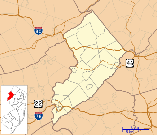
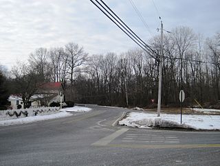
Warrington is an unincorporated community located within Knowlton Township in Warren County, New Jersey, United States.
Carsons Mills is an unincorporated community located within Robbinsville Township in Mercer County, New Jersey, United States. The community is located at the junctions of the Assunpink Creek and the New Sharon Branch creek and Sharon Road and Windsor Road southeast of the New Jersey Turnpike. Developed areas nearby include small residences and farmland while the undeveloped areas are forest and floodplains as a part of the Assunpink Wildlife Management Area.

Darts Mills is a historic unincorporated community located within Readington Township in Hunterdon County, New Jersey, United States. It is located on the South Branch of the Raritan River, and several mills were built there in the early 18th century. At its height, a merchant, blacksmith, store and complex of mills were here. The last mill at this site burnt down in 1994. Foundation walls and a mill race remain at the site today. On April 29, 1982, Dart's Mill was added to the National Register of Historic Places.

Westons Mills or Westons Mill is an unincorporated community located along the border of East Brunswick and New Brunswick in Middlesex County, New Jersey, United States. It is the location of Westons Mill Pond.

Algers Mills or Algers Mill is an unincorporated community located within Wall Township in Monmouth County, New Jersey, United States.

Bergen Mills is an unincorporated community located within Millstone Township in Monmouth County, New Jersey, United States. Centered on Bergen Mills Road, Millstone Road, and Route 33, the area is made up of mostly farmland with some residential homes scattered about, small business along Route 33, and a rock quarry on Old Bergen Mills Road.
Henningers Mills or Henningers Mill is an unincorporated community located along the border of Aberdeen and Marlboro townships in Monmouth County, New Jersey, United States.
Homes Mills or Holmes Mills is an unincorporated community located within Upper Freehold Township in Monmouth County, New Jersey, United States. The settlement is located along Holmes Mill Road [sic] where it crosses the Miry Run. The land around the Miry Run is hilly and forested but on the north side of the stream there are horse farms and housing developments on the south side.

Kirbys Mills is an unincorporated community located within Upper Freehold Township in Monmouth County, New Jersey, United States. Centered near the intersection of Burlington Path Road and Holmes Mill Road, the area consists of housing developments and small farms.
Osbornes Mills is an unincorporated community located within Wall Township in Monmouth County, New Jersey, United States.
Remsen Mills or Remsen Mill is an unincorporated community located within Wall Township in Monmouth County, New Jersey, United States.

Spring Mill is an unincorporated community located within Upper Freehold Township in Monmouth County, New Jersey, United States. The settlement is located along County Route 524 between Hamilton Township and Allentown on a commercialized segment of the road originally built as New Jersey Route 37. A vestige of the state construction remains along the road through a wide right-of-way and a bridge crossing Doctor's Creek stating that it was constructed by the state in 1940 for State Highway Route 37.
Wyckoff Mills is an unincorporated community located within Howell Township in Monmouth County, New Jersey, United States. The settlement is centered about the intersection of Wyckoff Mills Road and Strickland Road, just east of U.S. Route 9 in the western sector of the township.


