Rogue River, Oregon

Last updated

Rogue River, Oregon
Jackson County Oregon Incorporated and Unincorporated areas Rogue River Highlighted.svg
Location in Oregon
Coordinates: 42°26′9″N123°10′19″W / 42.43583°N 123.17194°W / 42.43583; -123.17194
Country United States
State Oregon
County Jackson
Incorporated 1912
Government
   Mayor Pam VanArsdale
Area
[1]
  Total0.96 sq mi (2.50 km2)
  Land0.96 sq mi (2.50 km2)
  Water0.00 sq mi (0.00 km2)
Elevation
1,004 ft (306 m)
Population
 (2020) [2]
  Total2,407
  Density2,494.30/sq mi (963.54/km2)
Time zone UTC−08:00 (Pacific)
  Summer (DST) UTC−07:00 (Pacific)
ZIP Code
97537
Area code 541
FIPS code 41-63450 [3]
GNIS feature ID1166706 [4]
Website www.cityofrogueriver.org

Rogue River is a city in Jackson County, Oregon, United States. As of the 2020 census the population was 2,407. [5]

Contents

History

In the early days the gold seekers forded the Rogue River, and during high water they swam across by holding the tails of their horses. Thus the river crossing near the present City of Rogue River, became known as Tailholt.

About 1850 or 51, Davis Evans built a ferry and two cabins at the mouth of Evans Creek. From there a trail was made by the mules of the pack trains that freighted supplies to the gold mines. According to John Breeding, who later freight supplies over the trail on mules and in carts made from the front wheels of wagons, the trail led up Evans Creek, then cut across to Ditch Creek where it passed the hewed log house of the old Burkhart ranch, and ran along the field and over the mountain gap to Jump-Off Joe Creek. A few log cabins, widely scattered over the area marked the locations of the early settlers' homesteads and mining claims.

In 1868, according to an old newspaper clipping, a covered bridge was built beside the big live oak tree near the ferry, for the stage road crossing of Evans Creek. Samuel A. Steckel furnished timbers to repair the bridge in 1883. When it was dismantled in 1912 some of the timbers, 80 feet in length, were so well preserved they were saved for use in the bridge eight miles up the creek.

In 1872, John Woods settled on the East side of Evans Creek, and soon the town of Woodville was built. The lumber for the first frame houses in Evans Valley and in Woodville was sawed by a sash mill located four miles up Evans Creek. Its single blade was powered by the water wheel of the old mill dam. Steckel owned and ran the mill for many years.

In 1912, the town was renamed City of Rogue River. The Woodville post office operated from 1876 until 1912, when the name was changed to Rogue River. [6]

Geography and climate

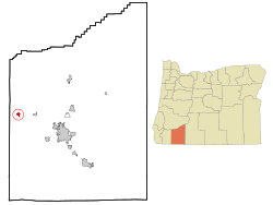
The city of Rogue River is in western Jackson County, on the north side of the Rogue River. Interstate 5 passes through the south side of the city, running along the north bank of the river. Access is from Exit 48 (Depot Street). I-5 leads west (northbound) 9 miles (14 km) to Grants Pass and southeast 20 miles (32 km) to Medford, the Jackson county seat.

According to the United States Census Bureau, the city of Rogue River has a total area of 0.97 square miles (2.51 km2), all of it land. [7]

Climate data for Rogue River, Oregon
MonthJanFebMarAprMayJunJulAugSepOctNovDecYear
Mean daily maximum °F (°C)46.9
(8.3)
53.3
(11.8)
58.8
(14.9)
64.4
(18.0)
72.5
(22.5)
80.3
(26.8)
89.2
(31.8)
89.2
(31.8)
81.2
(27.3)
68.7
(20.4)
52.3
(11.3)
45.3
(7.4)
66.8
(19.3)
Mean daily minimum °F (°C)33.0
(0.6)
34.1
(1.2)
36.3
(2.4)
39.6
(4.2)
44.9
(7.2)
50.2
(10.1)
55.1
(12.8)
54.1
(12.3)
47.4
(8.6)
40.4
(4.7)
36.4
(2.4)
33.1
(0.6)
42.1
(5.6)
Average rainfall inches (mm)7.12
(181)
5.05
(128)
4.34
(110)
2.87
(73)
2.09
(53)
1.11
(28)
0.41
(10)
0.33
(8.4)
0.71
(18)
3.01
(76)
5.40
(137)
8.53
(217)
40.97
(1,041)
Average snowfall inches (cm)0.7
(1.8)
0.3
(0.76)
0.2
(0.51)
0
(0)
0
(0)
0
(0)
0
(0)
0
(0)
0
(0)
0
(0)
0
(0)
0.8
(2.0)
2.0
(5.1)
Source 1: [8]
Source 2: [9]

Demographics

Historical population
CensusPop.Note
1920 211
1930 28635.5%
1940 38333.9%
1950 59054.0%
1960 520−11.9%
1970 84161.7%
1980 1,30855.5%
1990 1,75934.5%
2000 1,8475.0%
2010 2,13115.4%
2020 2,40713.0%
U.S. Decennial Census [10] [2]

2020 census

As of the census [11] of 2020, there were 2,407 people, 1233 households, and 996 families living in the city.

2010 census

As of the census [12] of 2010, there were 2,131 people, 1,054 households, and 539 families living in the city. The population density was 2,196.9 inhabitants per square mile (848.2/km2). There were 1,160 housing units at an average density of 1,195.9 per square mile (461.7/km2). The racial makeup of the city was 93.3% White, 0.8% African American, 1.2% Native American, 0.4% Asian, 2.1% from other races, and 2.2% from two or more races. Hispanic or Latino of any race were 5.3% of the population.

There were 1,054 households, of which 21.9% had children under the age of 18 living with them, 37.6% were married couples living together, 9.7% had a female householder with no husband present, 3.9% had a male householder with no wife present, and 48.9% were non-families. 43.8% of all households were made up of individuals, and 27.4% had someone living alone who was 65 years of age or older. The average household size was 2.02 and the average family size was 2.78.

The median age in the city was 49.3 years. 19.4% of residents were under the age of 18; 6.6% were between the ages of 18 and 24; 20.2% were from 25 to 44; 24.2% were from 45 to 64; and 29.6% were 65 years of age or older. The gender makeup of the city was 46.3% male and 53.7% female.

2000 census

As of the census [3] of 2000, there were 1,847 people, 902 households, and 484 families living in the city. The population density was 903.7 inhabitants per square mile (348.9/km2). There were 949 housing units at an average density of 978.1 per square mile (377.6/km2). The racial makeup of the city was 93.72% White, 0.22% African American, 1.41% Native American, 0.27% Asian, 0.27% Pacific Islander, 1.62% from other races, and 2.49% from two or more races. Hispanic or Latino of any race were 5.09% of the population.

There were 902 households, out of which 19.8% had children under the age of 18 living with them, 41.1% were married couples living together, 9.5% had a female householder with no husband present, and 46.3% were non-families. 41.8% of all households were made up of individuals, and 29.9% had someone living alone who was 65 years of age or older. The average household size was 2.03 and the average family size was 2.74.

In the city, the population was spread out, with 20.0% under the age of 18, 6.1% from 18 to 24, 18.9% from 25 to 44, 21.3% from 45 to 64, and 33.6% who were 65 years of age or older. The median age was 50 years. For every 100 females, there were 79.0 males. For every 100 females age 18 and over, there were 73.8 males.

The median income for a household in the city was $23,419, and the median income for a family was $34,583. Males had a median income of $32,115 versus $20,764 for females. The per capita income for the city was $16,789. About 9.9% of families and 13.1% of the population were below the poverty line, including 12.5% of those under age 18 and 6.2% of those age 65 or over.

Points of interest

Media

Rogue River is served by the weekly Rogue River Press . [13]

Notable residents

Related Research Articles

<span class="mw-page-title-main">Jackson County, Oregon</span> County in Oregon, United States

Jackson County is one of the 36 counties in the U.S. state of Oregon. As of the 2020 census, the population was 223,259. The county seat is Medford. The county is named for Andrew Jackson, the seventh president of the United States.

<span class="mw-page-title-main">Douglas County, Oregon</span> County in Oregon, United States

Douglas County is one of the 36 counties in the U.S. state of Oregon. As of the 2020 census, the population was 111,201. The county seat is Roseburg. The county is named after Stephen A. Douglas, an American politician who supported Oregon statehood. Douglas County comprises the Roseburg, OR Micropolitan Statistical Area. In regards to area, Douglas County is the largest county west of the Oregon Cascades.

<span class="mw-page-title-main">Ashland, Nebraska</span> City in Saunders County, Nebraska, United States

Ashland is a city in Saunders County, Nebraska, United States. The population was 3,086 at the 2020 census.

<span class="mw-page-title-main">Pleasant Valley, Missouri</span> Place in Missouri, United States

Pleasant Valley is a city in Clay County, Missouri, United States. The population was 2,743 at the 2020 census. It is part of the Kansas City metropolitan area.

<span class="mw-page-title-main">Woodville, Ohio</span> Village in Ohio, United States

Woodville is a village in Sandusky County, Ohio, United States. The population was 2,006 at the 2020 census. The National Arbor Day Foundation has designated Woodville as a Tree City USA.

<span class="mw-page-title-main">St. Helens, Oregon</span> City in and county seat of Columbia County, Oregon

St. Helens is the county seat of Columbia County, Oregon. It was founded by Captain Henry Montgomery Knighton, a native of New England, in 1845, as "Plymouth". The name was changed to St. Helens in the latter part of 1850 for its view of Mount St. Helens, roughly 39 miles (63 km) away in Washington. The city is about 28 miles (45 km) northwest of Portland. Its population was 12,883 at the 2010 census.

<span class="mw-page-title-main">Gold Beach, Oregon</span> City in Oregon, United States

Gold Beach is a city in and the county seat of Curry County, Oregon, United States, on the Oregon Coast. The population was 2,241 at the 2020 census.

<span class="mw-page-title-main">Myrtle Creek, Oregon</span> City in Oregon, United States

Myrtle Creek is a city in Douglas County, Oregon, United States. The population was 3,439 at the 2010 census.

<span class="mw-page-title-main">Central Point, Oregon</span> City in Oregon, United States

Central Point is a city in Jackson County, Oregon, United States. The population was 17,169 as of 2010. The city shares its southern border with Medford and is a part of the Medford metropolitan area. Central Point is home of the Jackson County Fair that occurs in July.

<span class="mw-page-title-main">Eagle Point, Oregon</span> City in Oregon, United States

Eagle Point is a city in Jackson County, Oregon, United States. The population was 8,469 at the 2010 census, up from 4,798 at the 2000 census. As of 2018, the estimated population was 9,408.

<span class="mw-page-title-main">Gold Hill, Oregon</span> City in Jackson County, Oregon, United States

Gold Hill is a city in Jackson County, Oregon, in the United States. As of the 2010 census the population was 1,335. It is along a bend of the Rogue River.

<span class="mw-page-title-main">Phoenix, Oregon</span> City in Oregon, United States

Phoenix is a city in Jackson County, Oregon, United States. The population was 4,538 at the 2010 census. Phoenix is a part of the Medford Metropolitan Statistical Area, in the Rogue Valley, and is 3 miles (5 km) southeast of Medford on Interstate 5.

<span class="mw-page-title-main">Talent, Oregon</span> City in Oregon, United States

Talent is a city in Jackson County, Oregon, United States. The population was 6,282 at the 2020 census.

<span class="mw-page-title-main">Scio, Oregon</span> City in Oregon, United States

Scio is a city in Linn County, Oregon, United States. The population was 838 at the 2010 census.

<span class="mw-page-title-main">Scotts Mills, Oregon</span> City in Oregon, United States

Scotts Mills is a city in Marion County, Oregon, United States. The population was 419 at the 2020 census. It is 2 miles (3 km) south of Marquam and Oregon Route 213, between Silverton and Molalla.

<span class="mw-page-title-main">Turner, Oregon</span> City in Oregon, United States

Turner is a city in Marion County, Oregon, United States. The population was 2,944 at the 2020 census. It is part of the Salem Metropolitan Statistical Area. The community was incorporated by the Oregon Legislative Assembly on February 10, 1905.

<span class="mw-page-title-main">Summerville, Oregon</span> City in Oregon, United States

Summerville is a city in Union County, Oregon, United States. The population was 135 at the 2010 census.

<span class="mw-page-title-main">Gates, Oregon</span> City in Oregon, United States

Gates is a city on the border of Linn and Marion counties in Oregon, United States. The population was 548 at the 2020 census. The greater part of Gates' population is in Marion County and the city is primarily under Marion County's jurisdiction.

<span class="mw-page-title-main">Sutherlin, Oregon</span> City in Oregon, United States

Sutherlin is a city in Douglas County, Oregon, United States. As of the 2010 Census, the population was 7,810, making it the second most populous city in Douglas County. Located off of I-5, nearby features include Cooper Creek Reservoir, Ford's pond, the Umpqua River, a golf course, and numerous vineyards.

<span class="mw-page-title-main">Shady Cove, Oregon</span> City in Oregon, United States

Shady Cove is a city in Jackson County, Oregon, United States. The population was 2,904 at the 2010 census.

References

  1. "ArcGIS REST Services Directory". United States Census Bureau. Retrieved October 12, 2022.
  2. 1 2 "Census Population API". United States Census Bureau. Retrieved October 12, 2022.
  3. 1 2 "U.S. Census website". United States Census Bureau . Retrieved January 31, 2008.
  4. "US Board on Geographic Names". United States Geological Survey. October 25, 2007. Retrieved January 31, 2008.
  5. "Geography Profile: 2020 Census Summary File 1 (G001): Rogue River city, Oregon". U.S. Census Bureau.
  6. McArthur, Lewis A.; McArthur, Lewis L. (2003) [1928]. Oregon Geographic Names (7th ed.). Portland, Oregon: Oregon Historical Society Press. pp. 822–823. ISBN   978-0875952772.
  7. "US Gazetteer files 2010". United States Census Bureau. Archived from the original on July 2, 2012. Retrieved December 21, 2012.
  8. "Rogue River, Oregon Climate". www.bestplaces.net. Retrieved August 12, 2021.
  9. "NOAA NCEI U.S. Climate Normals Quick Access". National Oceanic and Atmospheric Administration . Retrieved August 12, 2021.
  10. "Census of Population and Housing". Census.gov. Retrieved June 4, 2015.
  11. "U.S. Census website". United States Census Bureau . Retrieved December 21, 2012.
  12. "U.S. Census website". United States Census Bureau . Retrieved December 21, 2012.
  13. "Rogue River Press".