Roman cities in Britain

Last updated

Traditional arrangement of the Roman provinces after Camden, Roman Britain 410.jpg
Traditional arrangement of the Roman provinces after Camden,

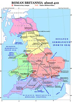
This is a list of cities in Great Britain during the period of Roman occupation from 43 AD to the 5th century.

Roman cities were known as civitas in Latin. They were mostly fortified settlements where native tribal peoples lived, governed by the Roman officials. The majority of the cities (civitates) listed are either former Iron Age tribal capitals, strategic settlements on Roman roads, trading posts between tribal groups or, occasionally, ports, although the latter two were more usually not defined as civitas. A small number of these cities were settlements of Roman origin, the most famous of which is Aquae Sulis, modern day Bath. At least 26 of the current 63 cities in England and Wales were fortified civitates during the Roman era, the most famous being Camulodunum, modern day Colchester, the first capital of the Roman province of Britannia, and Londinium, modern day London, the later capital of the province and current capital of both England and the United Kingdom today.

This list covers cities throughout Great Britain but does not include Cornwall or Scotland where the Romans had less influence. The list shows the modern (Anglo-Saxon) settlement names as well as the native Brythonic and Roman names for the settlement. Civitates were prefixed with Caer in Brythonic which roughly equates to the same word in modern Welsh, meaning "stronghold", "fortress", or "citadel", usually written in Anglo-Saxon as -caster, -cester, and -chester. The eighth century Welsh monastic author of the Historia Brittonum , Nennius, recorded 28 civitates, which together make up a large proportion of the cities in this list (26 out of the 28 are listed with their likely locations, but several are by no means certain). However, "Caer Custoeint" and "Caer Brithon" are not included, the former having an unknown location and the latter being in Scotland and unlikely to actually have been a Roman civitas. [2] Many of the Roman civitates transitioned into Anglo-Saxon settlements during the Dark Ages, remaining as cities or large towns today. Others, however, fell into disrepair and little but ruins remain, often close to small villages.
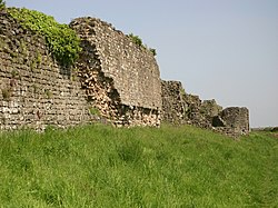
Modern SettlementBrythonic NameRoman NameTribe AssociatedHistoric CountyFlagCurrent StatusImageMentioned by Nennius
Alcester Caer AlenAlaunaLocal Tribe Warwickshire Town Old road bridge, Alcester - geograph.org.uk - 1877198.jpg No
Aldborough Caer Isurion Isurium Brigantum Brigantes West Riding of Yorkshire Village Roman ruins in Aldborough (8093).jpg No
Bath Caer Baddon Aquae Sulis Roman Settlement Somerset Flag of Bath.png City Roman Baths, Bath, 2017.jpg No
Brough Caer Petuar Petuaria Parisi East Riding of Yorkshire Town HER Museum 6 July 2018 Petuaria 2.jpg No
Builth Wells Caer PerisUnknown Ordovices & Silures Brecknockshire Town Gateway to Caer Beris - geograph.org.uk - 1042227.jpg Yes
Caernarfon Caer Segeint Segontium Ordovices Caernarfonshire Town Segontium ruins in Caernarfon (7553).jpg Yes
Caistor (Thancaster)Caer Correi Caistor Corieltauvi Lincolnshire Town Spa Top, Caistor - geograph.org.uk - 3400456.jpg No
Cambridge Caer Grauth Duroliponte Catuvellauni Cambridgeshire Flag of the City of Cambridge.png City Roman Road towards Cambridge - geograph.org.uk - 1017375.jpg Yes
Canterbury Caer Ceint Durovernum Cantiacorum Cantiaci Kent Flag of Canterbury.png City Canterbury - Castle01.jpg Yes
Cardiff Caer Teim Tamium Silures Glamorgan Flag of Cardiff.svg City Cardiff Castle - North Gate - 2022-08-18 (1).jpg No
Carlisle Capital of Britannia Valentia Caer Ligualid Luguvalium Carvetii Cumberland Flag of Carlisle.png City Birdoswald 2014 27.jpg Yes
Carmarthen Caer Merddyn Moridunum Demetae Carmarthenshire Town Amphitheatre Moridunum - geograph.org.uk - 777546.jpg Unlikely
Catterick Caer Catarauc Cataractonium Brigantes North Riding of Yorkshire Village Agricola Bridge, Catterick - geograph.org.uk - 276655.jpg Yes
Chepstow (Caerwent)Caer Guent (possibly) Venta Silurum Silures Monmouthshire Town (Village) CaerwentWall.jpg Yes
Chester Caer Legion Deva Victrix Cornovii (Midlands) Cheshire Flag of Chester.png City The Roman Amphitheatre, Deva Victrix (Chester, UK) (8391144271).jpg Yes
Chichester Caer Cei Noviomagus Reginorum Regni Sussex Flag of Chichester.png City Along the City Walls, Chichester - geograph.org.uk - 2475033.jpg No
Cirencester Capital of Britannia Prima Caer Ceri Corinium Dobunnorum Dobunni Gloucestershire Town Roman Amphitheatre, Cirencester - geograph.org.uk - 2827606.jpg No
Colchester Early Capital of Britannia Caer Colun Camulodunum Trinovantes Essex Colchester Flag.png City (2022) [3] South-east corner of Colchester's Roman wall - geograph.org.uk - 545333.jpg Yes
Conwy (Caerhun)Caer Canovion (Informally) [4] Canovium Deceangorum Deceangli Denbighshire Town (Village) Caerhun lychgate and church.jpg No
Doncaster Caer DaunDanumRoman Settlement West Riding of Yorkshire Flag of Doncaster.png City (2022) [3] Roman Road heading north - geograph.org.uk - 2602375.jpg Yes
Dorchester Caer Durnac Durnovaria Durotriges Dorset Town Roman villa, Dorchester - geograph.org.uk - 473451.jpg No
Dunster Caer DraitouUnknown Dumnonii Somerset Village Dunster, Exmoor - geograph.org.uk - 3259946.jpg Yes
Durham (Binchester)Caer Weir Vinovia Brigantes County Durham Flag of Durham.svg City (Village) Binchester Roman Fort.jpg No
Exeter Caer Uisc Isca Dumnoniorum Dumnonii Devon Exeter Flag.png City Tower, city walls, Exeter - geograph.org.uk - 1082975.jpg No
Gloucester Capital of Britannia Secunda Caer Glout Glevum Dobunii Gloucestershire Gloucester Flag.png City Chedworth Roman Villa 2012 - View from northeast.jpg No
Hereford (Kenchester)Caer Fawydd Magnae Dobunnorum Dobunni Herefordshire Flag of Hereford.png City (Village) Roman Road crosses the Wye, near Kenchester - geograph.org.uk - 25275.jpg No
Ilchester Caer Pensa vel Coyt Lindinis Lendinienses, part of Durotriges? Somerset Village Ilchester, below Ilchester Bridge - geograph.org.uk - 3018084.jpg Yes
Leicester Caer Lerion Ratae Corieltauvorum Corieltauvi Leicestershire Flag of the City of Leicester.png City The Jewry Wall - geograph.org.uk - 2115631.jpg Yes
Lichfield (Wall)Caer Luit coyt Letocetum Cornovii (Midlands) & Corieltauvi Staffordshire Flag of Lichfield.png City (Village) Letocetum - Wall Roman Site (32033944682).jpg Yes
Lincoln Capital of Britannia Flavia Caer Lind-colun Lindum Colonia Corieltauvi Lincolnshire Flag of Lincoln.svg City Newport Arch.jpg No
City of London Later Capital of Britannia Caer Londein Londinium Catuvellauni & Trinovantes Middlesex Flag of the City of London.svg City Londinium Roman Wall (40333720812).jpg Yes
Manchester Caer Maunguid Mamucium Roman Settlement Lancashire Flag of Manchester.png City Romeinse ruines (2).jpg Yes
Monmouth (The Doward)Caer Guorthigirn Blestium Silures Monmouthshire / Herefordshire Monmouth flag.jpg Town (Village) View from The Great Doward 1 - geograph.org.uk - 1397853.jpg Yes, Probably
Norwich (Caistor St Edmund)Caer Guin Truis (possibly) Venta Icenorum Iceni Norfolk Flag of Norwich.svg City (Village) Venta Icenorum - geograph.org.uk - 1999974.jpg No
Newport (Caerleon)Caer legion guar uisc Isca Augusta Silures Monmouthshire Flag of Newport.png City (Town) Caerleon Amphitheatre 20171016 west entrance seen from arena.jpg Yes
Portsmouth (Portchester)Caer Portus Portus Adurni Belgae Hampshire City Flag of Portsmouth.svg City (Village) Landgate Tower, Porchester Castle - geograph.org.uk - 1416754.jpg No
Rochester Caer Dourbruf Durobrivae Cantiacorum Cantiaci Kent Town Remains of Roman wall ([?]200 D.C.) - panoramio.jpg No
Salisbury (Old Sarum)Caer Sallwg Sorbiodunum Atrebates Wiltshire Salisbury Flag.svg City OLD SARUM ruins.jpg Yes
Shrewsbury (Wroxeter)Caer Guricon Viroconium Cornoviorum Cornovii (Midlands) Shropshire Town (Village) Viroconium Cornoviorum 07.jpg Yes
Silchester Caer Celemion Calleva Atrebatum Atrebates Hampshire Village The southwest wall of Calleva Atrebatum - geograph.org.uk - 2046014.jpg Yes
St Albans Caer Municep Verulamium Catuvellauni Hertfordshire FlagOfStAlbans-PS01.svg City The Roman Theatre at Verulamium, St Albans (14027376710).jpg Yes
Whitchurch Caer Meguidd Mediolanum Cornovii (Midlands) Shropshire Town Farmland beside the Kingsclere to Whitchurch road - geograph.org.uk - 813552.jpg Yes
Winchester Caer Guent (possibly) Venta Belgarum Belgae Hampshire Winchester Flag.png City Steps at Winchester, Hampshire - geograph.org.uk - 1744000.jpg Yes
Worcester Caer Guiragon Vertis Dobunii & Cornovii (Midlands) Worcestershire Flag of Worcester.png City Track of Roman road approaching Worcester - geograph.org.uk - 2666761.jpg Yes
York Capital of Britannia Maxima Caer Ebrauc Eboracum Brigantes North Riding of Yorkshire Flag of York.svg City York UK Wall Roman Foundation.JPG Yes

Related Research Articles

<span class="mw-page-title-main">Dumnonii</span> Celtic tribe in southwestern Britain during the Iron Age

The Dumnonii or Dumnones were a British tribe who inhabited Dumnonia, the area now known as Cornwall and Devon in the further parts of the South West peninsula of Britain, from at least the Iron Age up to the early Saxon period. They were bordered to the east by the Durotriges tribe.

<span class="mw-page-title-main">Caer</span> Placename element in Welsh meaning "stronghold", "fortress", or "citadel".

Caer is a placename element in Welsh meaning "stronghold", "fortress", or "citadel", roughly equivalent to an Old English suffix (-ceaster) now variously written as -caster, -cester, and -chester.

Dumnonia is the Latinised name for a Brythonic kingdom that existed in Sub-Roman Britain between the late 4th and late 8th centuries CE in the more westerly parts of present-day South West England. It was centred in the area of modern Devon, but also included modern Cornwall and part of Somerset, with its eastern boundary changing over time as the gradual westward expansion of the neighbouring Anglo-Saxon kingdom of Wessex encroached on its territory. The spelling Damnonia is sometimes encountered, but that spelling is also used for the land of the Damnonii, later part of the Kingdom of Strathclyde, in present-day southern Scotland. The form Domnonia also occurs and shares a linguistic relationship with the Breton region of Domnonée.

<span class="mw-page-title-main">Iceni</span> Roman-era British tribe

The Iceni or Eceni were an ancient tribe of eastern Britain during the Iron Age and early Roman era. Their territory included present-day Norfolk and parts of Suffolk and Cambridgeshire, and bordered the area of the Corieltauvi to the west, and the Catuvellauni and Trinovantes to the south. In the Roman period, their capital was Venta Icenorum at modern-day Caistor St Edmund.

<span class="mw-page-title-main">Cornovii (Midlands)</span> Celtic people of the Iron Age and Roman Britain

The Cornovīī were a Celtic people of the Iron Age and Roman Britain, who lived principally in the modern English counties of Cheshire, Shropshire, north Staffordshire, north Herefordshire and eastern parts of the Welsh counties of Flintshire, Powys and Wrexham. Their capital in pre-Roman times was probably a hillfort on the Wrekin. Ptolemy's 2nd-century Geography names two of their towns: Deva Victrix (Chester) and Viroconium Cornoviorum (Wroxeter), which became their capital under Roman rule.

<span class="mw-page-title-main">Regni</span> Late Iron Age and Roman era British tribe

The Regni, Regini, or Regnenses were a tribe based largely on Sussex and which occupied modern West Sussex, East Sussex, south-west Kent, eastern Surrey, and the eastern edges of Hampshire. Their tribal centre was at Noviomagus Reginorum, close to Trisantona Fluvius which joined the English Channel at Littlehampton, a little way to the east of Noviomagus Reginorum. The tribe was bordered to the west by the Belgae, to the north by the Atrebates, and to the east by the Cantiaci, while much of their northern border was filled by the vast and near-impenetrable Weald Forest. Nevertheless, they were thinly scattered on either side of the Weald, and there were safe paths through the forest.

<span class="mw-page-title-main">Caerwent</span> Human settlement in Monmouthshire, Wales

Caerwent is a village and community in Monmouthshire, Wales. It is located about five miles west of Chepstow and 11 miles east of Newport. It was founded by the Romans as the market town of Venta Silurum, an important settlement of the Brythonic Silures tribe. The modern village is built around the Roman ruins, which are some of the best-preserved in Europe. It remained prominent through the Roman era and Early Middle Ages as the site of a road crossing between several important civic centres. The community includes Llanvair Discoed. The village itself had a population of about 1,200.

<span class="mw-page-title-main">Durnovaria</span>

Durnovaria is a suggested spelling for the Latin form of the name of the Roman town of Dorchester in the modern English county of Dorset, amended from the actually observed Durnonovaria. Upon the assumption that the name was originally Brythonic, it is suggested that the first element in the name, *durno- may mean "fist" like and the second may be related to Old Irish fáir ~ fóir denoting a confined area or den. A simpler amendment would lead to *Duronovaria, making this place one of up to 18 ancient British names that contain Duro- and mostly occur at river crossings, while -novaria has two possible ancient parallels in Britain associated with river junctions. That analysis would perfectly fit the geographical situation of Dorchester.

<span class="mw-page-title-main">History of Devon</span>

Devon is a county in south west England, bordering Cornwall to the west with Dorset and Somerset to the east. There is evidence of occupation in the county from Stone Age times onward. Its recorded history starts in the Roman period when it was a civitas. It was then a separate kingdom for a number of centuries until it was incorporated into early England. It has remained a largely agriculture based region ever since though tourism is now very important.

<span class="mw-page-title-main">Isca Dumnoniorum</span> Roman legionary fortress in Devon, England

Isca Dumnoniorum, also known simply as Isca, was originally a Roman legionary fortress for the Second Augustan Legion in the Roman province of Britannia at the site of present-day Exeter in Devon.

<span class="mw-page-title-main">Sub-Roman Britain</span> Period in Late Antiquity in Great Britain

Sub-Roman Britain is the period of late antiquity in Great Britain between the end of Roman rule and the Anglo-Saxon settlement. The term was originally used to describe archaeological remains found in 5th- and 6th-century AD sites that hinted at the decay of locally made wares from a previous higher standard under the Roman Empire. It is now used to describe the period that commenced with the recall of Roman troops to Gaul by Constantine III in 407 and to have concluded with the Battle of Deorham in 577.

<span class="mw-page-title-main">Celtic Britons</span> Ancient Celtic people of Great Britain

The Britons, also known as Celtic Britons or Ancient Britons, were the indigenous Celtic people who inhabited Great Britain from at least the British Iron Age until the High Middle Ages, at which point they diverged into the Welsh, Cornish, and Bretons. They spoke Common Brittonic, the ancestor of the modern Brittonic languages.

<span class="mw-page-title-main">Segontium</span> Roman fort in Gwynedd, Wales

Segontium is a Roman fort on the outskirts of Caernarfon in Gwynedd, North Wales. The fort, which survived until the end of the Roman occupation of Britain, was garrisoned by Roman auxiliaries from present-day Belgium and Germany. It was the most important military base and administrative centre in this part of Britain.

<span class="mw-page-title-main">Hen Ogledd</span> Area of northern Britain, c. 500 to c. 800

Yr Hen Ogledd, or in English the Old North, is the historical region that was inhabited by the Brittonic people of sub-Roman Britain in the Early Middle Ages, now Northern England and the southern Scottish Lowlands, alongside the Celtic Kingdom of Elmet. Its population spoke a variety of the Brittonic language known as Cumbric which is closely related to, if not a dialect of Old Welsh. The people of Wales and the Hen Ogledd considered themselves to be one people, and both were referred to as Cymry ('fellow-countrymen') from the Brittonic word combrogi. The Hen Ogledd was distinct from the parts of North Britain inhabited by the Picts, Anglo-Saxons, and Scoti.

<span class="mw-page-title-main">Venta Belgarum</span> Town in Roman Britannia

Venta Belgarum, or Venta Bulgarum, was a town in the Roman province of Britannia Superior, the civitas capital of the local tribe, the Belgae, and which later became the city of Winchester.

Luguvalium was a Roman town in northern Britain in antiquity. It was located within present-day Carlisle, Cumbria, and may have been the capital of the 4th-century province of Valentia.

<span class="mw-page-title-main">Moridunum (Carmarthen)</span> Roman settlement at what is now Carmarthen in Wales

Moridunum was a Roman fort and town in the Roman province of Britannia. Today it is known as Carmarthen, located in the Welsh county of Carmarthenshire.

<span class="mw-page-title-main">Welsh toponymy</span> Place names of Wales

The place-names of Wales derive in most cases from the Welsh language, but have also been influenced by linguistic contact with the Romans, Anglo-Saxons, Vikings, Anglo-Normans and modern English. Toponymy in Wales reveals significant features of the country's history and geography, as well as the development of the Welsh language. Its study is promoted by the Welsh Place-Name Society.

<i>Limes Britannicus</i>

The frontier of the Roman Empire in Britain is sometimes styled Limes Britannicus by authors for the boundaries, including fortifications and defensive ramparts, that were built to protect Roman Britain. These defences existed from the 1st to the 5th centuries AD and ran through the territory of present-day England, Scotland and Wales.

Caer Gwinntguic was a late antique / early medieval British kingdom which had its center in the Roman city Venta Belgarum and the historic lands of the Belgae tribe. It acquired its own form of independence at the beginning of the fifth century as a result of the Rescript of Honorius, which left the inhabitants of the westernmost area of the Saxon Shore to organize their own defense.

References

  1. Camden, William (1610) [Original text published 1586], "The Division of Britaine", Britain, or, a Chorographicall Description of the most flourishing Kingdomes, England, Scotland, and Ireland, Translated by Philemon Holland
  2. "Britannia Articles: Nennius' Twenty-Eight British Cities". 15 April 2016. Archived from the original on 15 April 2016.
  3. 1 2 "Platinum Jubilee: Eight towns to be made cities for Platinum Jubilee". BBC. 20 May 2022.
  4. "Roman Britain: Deceangi Tribe". roman-britain.co.uk. 21 May 2022.