
Tierra Amarilla is a small unincorporated community near the Carson National Forest in the northern part of the U.S. state of New Mexico. It is the county seat of Rio Arriba County.
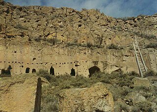
The Puye Cliff Dwellings are the ruins of an abandoned pueblo, located in Santa Clara Canyon on Santa Clara Pueblo land near Española, New Mexico. The site was declared a National Historic Landmark in 1966.

Las Trampas or just Trampas, is a small unincorporated town in Taos County, northern New Mexico, the Southwestern United States. Founded in 1751, its center retains the original early Spanish colonial defensive layout from that time, as well as the 18th-century San José de Gracia Church, one of the finest surviving examples of Spanish Colonial church architecture in the United States. The village center was designated a National Historic Landmark District in 1967.

Carson National Forest is a national forest in northern New Mexico, United States. It encompasses 6,070 square kilometers and is administered by the United States Forest Service. The Forest Service's "mixed use" policy allows for its use for recreation, grazing, and resource extraction.

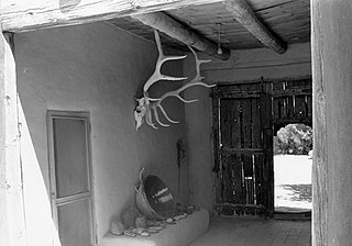
Martinez Hacienda, also known as Hacienda de los Martinez, is a Taos, New Mexico hacienda built during the Spanish colonial era. It is now a living museum listed on the National Register of Historic Places. It is located on the bank of the Rio Pueblo de Taos.

The Rio Chama, a major tributary river of the Rio Grande, is located in the U.S. states of Colorado and New Mexico. The river is about 130 miles (210 km) long altogether. From its source to El Vado Dam its length is about 50 miles (80 km), from El Vado Dam to Abiquiu Dam is about 51 miles (82 km), and from Abiquiu Dam to its confluence with the Rio Grande is about 34 miles (55 km).
Fort Selden was a United States Army post, occupying the area in what is now Radium Springs, New Mexico. The site was long a campground along the El Camino Real de Tierra Adentro. It was the site of a Confederate Army camp in 1861. The U. S. Army established Fort Selden in 1865 for the purpose of protecting westward settlers from Native American raids, the post fell into disrepair after the American Civil War. It was ultimately abandoned in 1891, due in large part to the decision to expand Fort Bliss and the lack of any expenditures for repair of the facility.

Abiquiú is a small census-designated place located in Rio Arriba County, in northern New Mexico in the southwestern United States, about 53 miles (85 km) north of Santa Fe. Abiquiu has an elementary school which is part of the Espanola Public Schools.

The Santa Fe Plaza is a National Historic Landmark in downtown Santa Fe, New Mexico in the style of traditional Spanish-American colonial cities. The plaza, or "city-square", was originally, and is still to this day, the center gathering place in town. Many know it as "the heart of Santa Fe". The landmark has since grown into a playground for many tourists interested in Spanish, Native American, and Mexican cultures, and includes music, design, jewelry, art and dance. Known to locals simply as the "Plaza," it is home to annual events including Fiestas de Santa Fe, the Spanish Market, the Santa Fe Bandstand, and the Santa Fe Indian Market.

The Albuquerque–Santa Fe–Las Vegas combined statistical area is made up of nine counties in north central New Mexico. The combined statistical area consists of the Albuquerque and Santa Fe metropolitan statistical areas, and the Las Vegas, Los Alamos, Española, and Grants micropolitan statistical areas. As of the 2010 census, the CSA had a population of 1,146,049. Roughly 55% of New Mexico's residents live in this area. Prior to the 2013 redefintions, the CSA consisted only of the Santa Fe metropolitan statistical area and the Española micropolitan statistical area. The total land area of the Albuquerque–Santa Fe–Las Vegas combined statistical area is 26,421 sq. mi.

Embudo is an unincorporated community in Rio Arriba County, New Mexico, United States. It is on NM State Road 68. The Embudo Station is located 2.9 miles south of the intersection of NM State Road 75, near where the Embudo River flows into the Rio Grande.

The Barrio de Analco Historic District is a National Historic Landmark District centered at the junction of East De Vargas Street and Old Santa Fe Trail in Santa Fe, New Mexico. The seven buildings of the district represent one of the oldest clusters of what were basically working-class or lower-class residences in North America, and are in a cross-section of pre-statehood architectural styles. It includes two of the oldest colonial-era buildings in the southwest, the San Miguel Mission church (1710), and the "Oldest House", built in 1620 and now a museum. The district was declared a National Historic Landmark in 1968.
The Georgia O'Keeffe Home and Studio is a historic house museum at 12 Palvadera Drive in Abiquiú, New Mexico. It was from 1945 until 1984 the principal residence and studio of artist Georgia O'Keeffe (1887-1986). It is now owned and managed by the Georgia O'Keeffe Museum in Santa Fe, through which guided tours can be arranged. It was designated a National Historic Landmark in 1998, as one of the most important artistic sites in the southwestern United States.

Seton Village is a National Historic Landmark District in a rural residential area south of Santa Fe in Santa Fe County, New Mexico. It encompasses a residential settlement and educational facility established in 1930 by Ernest Thompson Seton (1860-1946), an educator and conservationist best known as a founder of the Boy Scouts of America. The district includes the remains of Seton's 32-room home and other residential and educational buildings constructed mostly between 1930 and 1945. It was declared a National Historic Landmark in 1965.

San Estevan del Rey Mission Church is a Spanish mission church on the Acoma Pueblo Reservation in western New Mexico. Built between 1629 and 1641, it is one of the finest extant examples of hybrid Spanish Colonial and Puebloan architectural styles. It was named for Saint Stephen I of Hungary. The church was declared a National Historic Landmark in 1970, and is listed on the National Register of Historic Places.

San Gabriel de Yungue-Ouinge, or San Gabriel de Yunque, was the site of the first Spanish capital of its provincial territory of Santa Fe de Nuevo México. It is located where the Rio Chama meets the Rio Grande, west of present-day Ohkay Owingeh, New Mexico. The pueblo of Yuque Yunque was provided as a gesture of goodwill toward Juan de Oñate, and he founded his colonial government there. It was moved to Santa Fe in 1610. The site was declared a National Historic Landmark in 1964. The archaeological site was leveled and plowed over in 1984, and a historical marker has been placed on the west side of the Rio Grande, off the old New Mexico State Road 74.

Northern Rio Grande National Heritage Area is a federally designated National Heritage Area in the U.S. state of New Mexico. The national heritage area includes a section of the upper Rio Grande Valley that has been inhabited by the Puebloan peoples since the early Pre-Columbian era.

Abiquiu Dam is a dam on the Rio Chama, located about 60 miles (97 km) northwest of Santa Fe in Rio Arriba County, New Mexico. Built and operated by the U.S. Army Corps of Engineers (USACE), the dam is an earth embankment structure 354 feet (108 m) high and 1,800 feet (550 m) long, containing 11.8 million cubic yards of fill. The dam forms Abiquiu Lake, one of the largest lakes in New Mexico with a full storage capacity of 1,369,000 acre feet (1,689,000 dam3) and 5,200 acres (2,100 ha) of water. To date, the reservoir has never filled to capacity, with a record high of 402,258 acre feet (496,178 dam3), 29.4% of full pool, on June 22, 1987. The dam's primary purpose is flood control, in addition to irrigation and municipal water storage, and hydroelectric generation.

Taos Downtown Historic District is a historic district in Taos, New Mexico. Taos "played a major role in the development of New Mexico, under Spanish, Mexican, and American governments." It a key historical feature of the Enchanted Circle Scenic Byway of northern New Mexico.


