
The Rocky Mountains, also known as the Rockies, are a major mountain range in western North America. The Rocky Mountains stretch more than 4,800 kilometers (3,000 mi) from the northernmost part of British Columbia, in western Canada, to New Mexico in the Southwestern United States. Located within the North American Cordillera, the Rockies are somewhat distinct from the Pacific Coast Ranges, Cascade Range, and the Sierra Nevada, which all lie farther to the west.

Great Basin National Park is an American national park located in White Pine County in east-central Nevada, near the Utah border, established in 1986. The park is most commonly entered by way of Nevada State Route 488, which is connected to U.S. Routes 6 and 50 by Nevada State Route 487 via the small town of Baker, the closest settlement.

The Eastern Ghats are a discontinuous range of mountains along India's eastern coast. The Eastern Ghats run from the northern Odisha through Andhra Pradesh to Tamil Nadu in the south passing some parts of Karnataka and in the Wayanad region of Kerala. They are eroded and cut through by four major rivers of peninsular India, viz. Godavari, Mahanadi, Krishna, and Kaveri.

The Teton Range is a mountain range of the Rocky Mountains in North America. It extends for approximately 40 miles (64 km) in a north–south direction through the U.S. state of Wyoming, east of the Idaho state line. It is south of Yellowstone National Park and most of the east side of the range is within Grand Teton National Park.

The City of Rocks National Reserve, also known as the Silent City of Rocks, is a United States National Reserve and state park lying 2 miles (3.2 km) north of the south central Idaho border with Utah. It is widely known for its excellent rock climbing and rock formations.
Middle or The Middle may refer to:

Dinara is a mountain located on the border of Bosnia and Herzegovina and Croatia. It has two major peaks: Troglav and the eponymous Dinara. The peak called Dinara is the highest peak of Croatia, is shaped like a human head made of stone, and also has a prominence of 728 m.

The Pensacola Mountains are a large group of mountain ranges of the Transantarctic Mountains System, located in the Queen Elizabeth Land region of Antarctica,.

Massacre Rocks State Park is a history-focused public recreation area in the Northwest United States featuring the Massacre Rocks, a famous spot along the Oregon Trail and California Trail during the middle 19th century. The state park is located along the Snake River, ten miles (16 km) southwest of American Falls, in Power County, Idaho.

The Raft River is a 108-mile-long (174 km) tributary of the Snake River located in northern Utah and southern Idaho in the United States. It is part of the Columbia River Basin.

Okanagan Mountain Provincial Park is a provincial park within the Okanagan-Similkameen Regional District of British Columbia, Canada, focused on the mountain of the same name and located on the east side of Okanagan Lake, opposite Peachland and immediately south of the City of Kelowna. The park is one of the largest in the area, covering 110.38 square kilometres (42.62 sq mi). Most of the park is only accessible by foot, horseback, bicycle, or boat as motor vehicle access is restricted to BC Parks staff and technicians servicing the three telecommunications towers in the park.

The Snake Den Ridge Trail is an American hiking trail in the Great Smoky Mountains National Park of Cocke County, Tennessee. Winding its way up the backbone-like crest of Snake Den Ridge, the trail connects the Cosby Campground to the Appalachian Trail and provides the quickest access to the high peaks of the Eastern Smokies. The trail passes through three forest types— a mixed deciduous forest at its lower elevations, a substantial stand of heath bald on the more narrow sections of the ridge crest, and an old growth northern-style coniferous forest at its higher elevations.

Laurel Hill, also known as Laurel Ridge or Laurel Mountain, is a 70-mile-long (110 km) mountain in Pennsylvania's Allegheny Mountains. This ridge is flanked by Negro Mountain to its east and Chestnut Ridge to its west. The mountain is home to six state parks: Laurel Ridge State Park, Laurel Mountain State Park, Linn Run State Park, Kooser State Park, Laurel Hill State Park, and Ohiopyle State Park. The 70-mile-long (110 km) Laurel Highlands Hiking Trail runs the length of the ridge.

Medicine Rocks State Park is a park owned by the state of Montana in the United States. It is located about 25 miles (40 km) west-southwest of Baker, Montana, and 11 miles (18 km) north of Ekalaka, Montana. The park is named for the "Medicine Rocks," a series of sandstone pillars similar to hoodoos some 60 to 80 feet high with eerie undulations, holes, and tunnels in them. The rocks contain numerous examples of Native American rock art, and are considered a sacred holy place by Plains Indians. The park is 330 acres (130 ha) in size and 3,379 feet (1,030 m) in elevation. It is managed by the Montana Department of Fish, Wildlife and Parks. Theodore Roosevelt said Medicine Rocks was "as fantastically beautiful a place as I have ever seen". The park was listed on the National Register of Historic Places in 2017.
The Snake River Range is located in the U.S. states of Wyoming and Idaho and includes 10 mountains over 9,000 feet (2,700 m). The tallest peak in the range is Mount Baird at 10,030 feet (3,060 m). The range trends northwest to southeast and is bordered on the north by the Teton Range and the two ranges meet at Teton Pass. The Snake River Range is bordered by the Palisades Reservoir to the west and the Snake River, which sweeps completely around the eastern, southern and western part of the range. The range is approximate 30 miles (48 km) north to south and 33 miles (53 km) west to east, covering 528 square miles (1,370 km2). Along the southern boundary, the Snake River passes through Grand Canyon, also known as the Snake River Canyon. U.S. Route 26/U.S. Route 89 follows the course of the Snake River from Hoback Junction to the Palisades Reservoir.

The Albion Mountains are a mountain range in the U.S. states of Idaho (~99%) and Utah (~1%), spanning Cassia County, Idaho and barely reaching into Box Elder County, Utah. The highest point in the range is Cache Peak at 10,339 feet (3,151 m), and the range is a part of the Great Basin Divide and the Basin and Range Province. Most of the mountains are part of the Albion Division of the Minidoka Ranger District of Sawtooth National Forest.
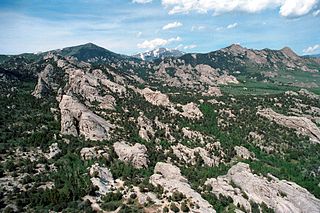
Cache Peak, at 10,339 feet (3,151 m) above sea level, is the highest peak in the Albion Mountains of Cassia County in Southern Idaho. Cache Peak is located in the central part of the range southeast of Oakley and north of Almo in the Albion Division of the Minidoka Ranger District of Sawtooth National Forest.
Mount Harrison, at 9,265 feet (2,824 m) is a peak in the northern Albion Mountains of Cassia County in southern Idaho. Mount Harrison is located in north of Cache Peak, south of Burley, northeast of Oakley, and west of Malta in the Albion Division of the Minidoka Ranger District of Sawtooth National Forest. Mount Harrison is in the watershed of tributaries of the Snake River, which itself is a tributary of the Columbia River. The peak can be reached via a paved road that runs all the way to its summit. Lake Cleveland is located in the basin north of the peak, and a small unnamed lake is located in the basin southeast of the peak.
State Highway 77 (SH-77) is a state highway in Cassia County, Idaho. The highway runs for 33.978 miles (54.682 km) from SH-81 in Malta to Interstate 84 north of Declo, serving the town of Albion.

Acorn Hill is a mountain located in the Catskill Mountains of New York northeast of Wittenberg. Snake Rocks is located southeast, and Johns Mountain is located north-northeast of Acorn Hill.


