
The Port Authority of New York and New Jersey, is a joint venture between the U.S. states of New York and New Jersey, established in 1921 through an interstate compact authorized by the United States Congress. The Port Authority oversees much of the regional transportation infrastructure, including bridges, tunnels, airports, and seaports, within the geographical jurisdiction of the Port of New York and New Jersey. This 1,500-square-mile (3,900 km2) port district is generally encompassed within a 25-mile (40 km) radius of the Statue of Liberty National Monument. The Port Authority is headquartered at 4 World Trade Center in Lower Manhattan.

Pennsylvania Station is the main intercity railroad station in New York City and the busiest transportation facility in the Western Hemisphere, serving more than 600,000 passengers per weekday as of 2019. The station is located beneath Madison Square Garden in the block bounded by Seventh and Eighth Avenues and 31st and 33rd Streets and in the James A. Farley Building, with additional exits to nearby streets, in Midtown Manhattan. It is close to several popular Manhattan locations, including Herald Square, the Empire State Building, Koreatown, and Macy's Herald Square.

The Port Authority Trans-Hudson (PATH) is a 13.8-mile (22.2 km) rapid transit system in the northeastern New Jersey cities of Newark, Harrison, Jersey City, and Hoboken, as well as Lower and Midtown Manhattan in New York City. It is operated as a wholly owned subsidiary of the Port Authority of New York and New Jersey. PATH trains run around the clock year-round; four routes serving 13 stations operate during the daytime on weekdays, while two routes operate during weekends, late nights, and holidays. It crosses the Hudson River through cast iron tunnels that rest on the river bottom. It operates as a deep-level subway in Manhattan and the Jersey City/Hoboken riverfront; from Grove Street in Jersey City to Newark, trains run in open cuts, at grade level, and on elevated track. In 2023, the system saw 55,109,100 rides, or about 185,600 per weekday in the first quarter of 2024, making it the fifth-busiest rapid transit system in the United States.

New Jersey Transit Corporation, branded as NJ Transit or NJTransit and often shortened to NJT, is a state-owned public transportation system that serves the U.S. state of New Jersey and portions of the states of New York and Pennsylvania. It operates buses, light rail, and commuter rail services throughout the state, connecting to major commercial and employment centers both within the state and in its two adjacent major cities, New York City and Philadelphia. In 2023, the system had a ridership of 209,259,800.

The Hudson–Bergen Light Rail (HBLR) is a light rail system in Hudson County, New Jersey, United States. Owned by New Jersey Transit (NJT) and operated by the 21st Century Rail Corporation, it connects the communities of Bayonne, Jersey City, Hoboken, Weehawken, Union City, at the city line with West New York, and North Bergen.

The Northeast Corridor Line is a commuter rail service operated by NJ Transit between the Trenton Transit Center and New York Penn Station on Amtrak's Northeast Corridor in the United States. The service is the successor to Pennsylvania Railroad commuter trains between Trenton and New York, and is NJ Transit's busiest commuter rail service. After arrival at New York Penn Station, some trains load passengers and return to New Jersey, while others continue east to Sunnyside Yard for storage. Most servicing is done at the Morrisville Yard, at the west end of the line.
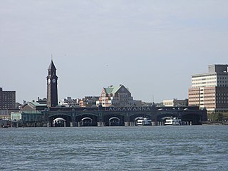
Hoboken Terminal is a commuter-oriented intermodal passenger station in Hoboken, Hudson County, New Jersey. One of the New York metropolitan area's major transportation hubs, it is served by eight NJ Transit (NJT) commuter rail lines, an NJ Transit event shuttle to Meadowlands Sports Complex, one Metro-North Railroad line, various NJT buses and private bus lines, the Hudson–Bergen Light Rail, the Port Authority Trans Hudson (PATH) rapid transit system, and NY Waterway-operated ferries.

Newark Penn Station is an intermodal passenger station in Newark, New Jersey. One of the New York metropolitan area's major transportation hubs, Newark Penn Station is served by multiple rail and bus carriers, making it the seventh busiest rail station in the United States, and the fourth busiest in the New York City metropolitan area.

For the purposes of this article, the Jersey City area extends North to Edgewater, South to Bayonne and includes Kearny Junction and Harrison but not Newark. Many routes east of Newark are listed here.

Newark Liberty International Airport Station is a railroad hub on the Northeast Corridor (NEC) in Newark, New Jersey. The station provides access to Newark Liberty International Airport (EWR) via the AirTrain Newark monorail which connects the station to the airport's terminals and parking areas. The station is served by New Jersey Transit's (NJT) Northeast Corridor Line and North Jersey Coast Line and Amtrak's Northeast Regional and Keystone Service trains.

The Journal Square Transportation Center is a multi-modal transportation hub located on Magnolia Avenue and Kennedy Boulevard at Journal Square in Jersey City, New Jersey, United States. Owned and operated by the Port Authority of New York and New Jersey, the complex includes a ten-story tower, a retail plaza, a bus terminal, a two-level parking facility, and the Journal Square station of the PATH rail transit system. The underground station has a high ceiling and a mezzanine level connecting the platforms.

Grove Street station is a station on the PATH system. Located at the intersection of Grove Street, Newark Avenue and Railroad Avenue in the Downtown neighborhood of Jersey City, New Jersey, it is served by the Newark–World Trade Center line at all times, the Journal Square–33rd Street line on weekdays, and the Journal Square–33rd Street line on weekends and during late-evening and early-morning weekday hours.

Harrison station is a station on the PATH system. Located on Frank E. Rodgers Boulevard between I-280 and the Passaic River in Harrison, New Jersey, it is served by the Newark–World Trade Center line at all times. The station's two side platforms are on the outside of the Northeast Corridor's three tracks.
Route 158 was a short state highway in Newark and Harrison, New Jersey, in the counties of Essex and Hudson, which are located in the United States. The Centre Street Bridge was first constructed in 1834 as a single-level railroad bridge. However, in 1911, almost eight decades later, a second, upper level was constructed for rapid transit. In 1937, the Hudson and Manhattan Railroad, now part of the Port Authority Trans-Hudson line, was realigned onto railroad tracks along New Jersey Route 21. The upper level of the bridge was abandoned for this purpose, and was later converted to roadway. At the western end in Newark it ran just south of Park Place, beginning at Center Street. The route headed eastward, crossing over Route 21 and the Passaic River before entering Harrison, where it terminated at Second Street north of New Jersey Railroad Avenue.

Exchange Place station is a station on the Port Authority Trans–Hudson (PATH) rail system in the Paulus Hook neighborhood of Jersey City, Hudson County, New Jersey. The station is on the Newark–World Trade Center line between Newark Penn Station and World Trade Center all week and the Hoboken–World Trade Center line during the day on weekdays to service Hoboken Terminal. Exchange Place provides access to the Jersey City waterfront and a station on the Hudson–Bergen Light Rail, where connections are available to Bayonne and North Bergen.

Newark–World Trade Center is a rapid transit service operated by the Port Authority Trans-Hudson (PATH). It is colored red on the PATH service map and trains on this service display red marker lights. This service operates from Pennsylvania Station in Newark, New Jersey, by way of the Downtown Hudson Tubes to the World Trade Center in Lower Manhattan, New York City, New York. Operating 24 hours a day, the 8.9-mile (14.3 km) trip takes 22+1⁄2 minutes to complete.

The North River Tunnels are a pair of rail tunnels that carry Amtrak and New Jersey Transit passenger lines under the Hudson River between Weehawken, New Jersey, and Pennsylvania Station in Manhattan, New York City, New York. Built between 1904 and 1908 by the Pennsylvania Railroad (PRR) to allow its trains to reach Manhattan, they opened for service in late 1910.

8th Street station is a station on the Hudson–Bergen Light Rail (HBLR) in the Bergen Point section of the city of Bayonne, New Jersey. The southernmost stop in Bayonne, 8th Street station serves as the southern terminus of the Hudson–Bergen Light Rail. Located on an elevated track next to Route 440, the station is accessible at the intersection of Avenue C and West 8th Street. The station, unlike the rest of the line, has a full station depot that doubles as accessibility to tracks per the Americans with Disabilities Act of 1990. The depot is two stories high and contains elevators and access to the platform, which is an island platform with two tracks. East of the station, the tracks merge into one to reach 22nd Street station. The station serves tracks for the local service to Hoboken Terminal along with an express service known as the Bayonne Flyer. The station opened on January 31, 2011 as an extension of service from 22nd Street.
Dayton is a neighborhood within the city of Newark in Essex County, in the U.S. state of New Jersey. It is part of the city's south ward

Transportation in New Jersey utilizes a combination of road, rail, air, and water modes. New Jersey is situated between Philadelphia and New York City, two major metropolitan centers of the Boston-Washington megalopolis, making it a regional corridor for transportation. As a result, New Jersey's freeways carry high volumes of interstate traffic and products. The main thoroughfare for long distance travel is the New Jersey Turnpike, the nation's fifth-busiest toll road. The Garden State Parkway connects the state's densely populated north to its southern shore region. New Jersey has the 4th smallest area of U.S. states, but its population density of 1,196 persons per sq. mi causes congestion to be a major issue for motorists.
