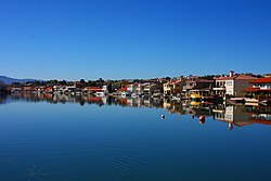
Spring Valley Lake | |
---|---|
Coordinates: 34°29′50″N117°16′08″W / 34.49722°N 117.26889°W | |
Country | United States |
State | California |
County | San Bernardino |
Area | |
• Total | 3.533 sq mi (9.149 km2) |
• Land | 2.969 sq mi (7.689 km2) |
• Water | 0.564 sq mi (1.460 km2) 15.95% |
Elevation | 2,779 ft (847 m) |
Population | |
• Total | 9,598 |
• Density | 2,700/sq mi (1,000/km2) |
Time zone | UTC-8 (Pacific (PST)) |
• Summer (DST) | UTC-7 (PDT) |
GNIS feature ID | 2583150 |
U.S. Geological Survey Geographic Names Information System: Spring Valley Lake, California |
Spring Valley Lake is a census-designated place in the Victor Valley of the Mojave Desert, within San Bernardino County, California. [2] It is located along the Mojave River.
Spring Valley Lake sits at an elevation of 2,779 feet (847 m). [2]
According to the United States Census Bureau, the CDP covers an area of 3.5 square miles (9.1 km2), 3.0 square miles (7.7 km2) of it land, and 0.6 square miles (1.5 km2) of it (15.95%) water.
At the 2010 census Spring Valley Lake had a population of 8,220. The population density was 2,327.0 inhabitants per square mile (898.5/km2). The racial makeup of Spring Valley Lake was 6,450 (78.5%) White (68.1% Non-Hispanic White), [4] 403 (4.9%) African American, 55 (0.7%) Native American, 381 (4.6%) Asian, 23 (0.3%) Pacific Islander, 481 (5.9%) from other races, and 427 (5.2%) from two or more races. Hispanic or Latino of any race were 1,528 persons (18.6%). [5]
The whole population lived in households, no one lived in non-institutionalized group quarters, and no one was institutionalized.
There were 3,072 households, 1,054 (34.3%) had children under the age of 18 living in them, 1,808 (58.9%) were opposite-sex married couples living together, 347 (11.3%) had a female householder with no husband present, 159 (5.2%) had a male householder with no wife present. There were 149 (4.9%) unmarried opposite-sex partnerships, and 22 (0.7%) same-sex married couples or partnerships. 596 households (19.4%) were one person and 294 (9.6%) had someone living alone who was 65 or older. The average household size was 2.68. There were 2,314 families (75.3% of households); the average family size was 3.06.
The age distribution was 1,932 people (23.5%) under the age of 18, 712 people (8.7%) aged 18 to 24, 1,842 people (22.4%) aged 25 to 44, 2,375 people (28.9%) aged 45 to 64, and 1,359 people (16.5%) who were 65 or older. The median age was 41.3 years. For every 100 females, there were 95.2 males. For every 100 females age 18 and over, there were 92.2 males.
There were 3,478 housing units at an average density of 984.6 per square mile, of the occupied units 2,273 (74.0%) were owner-occupied and 799 (26.0%) were rented. The homeowner vacancy rate was 3.2%; the rental vacancy rate was 7.7%. 5,694 people (69.3% of the population) lived in owner-occupied housing units and 2,526 people (30.7%) lived in rental housing units.
According to the 2010 United States Census, Spring Valley Lake had a median household income of $58,317, with 9.5% of the population living below the federal poverty line. [4]
It is in Victor Elementary School District and Victor Valley Union High School District [6]
Olancha is a census designated place in Inyo County of the U.S. state of California. Olancha is located on U.S. Route 395 in California, 37 miles (60 km) south-southeast of Independence. As of the 2010 census, the population was 192, up from 134 at the 2000 census.
Lake Isabella is a census-designated place (CDP) in the southern Sierra Nevada, in Kern County, California, United States. It is named after the Lake Isabella reservoir and located at its southwestern edge, 6 miles (9.7 km) south of Wofford Heights in the Kern River Valley.
Rosamond is an unincorporated community in Kern County, California, US, near the Los Angeles county line. Rosamond is part of Greater Los Angeles and is located in the Mojave Desert just north of Lancaster and Palmdale, two of the largest cities in Antelope Valley. As of the 2010 Census, Rosamond's population was 18,150. For statistical purposes, the United States Census Bureau has defined Rosamond as a census-designated place (CDP).
Lake Davis is a census-designated place (CDP) in Plumas County, California, United States, located on Lake Davis. The population was 45 at the 2010 census.
Adelanto is a city in San Bernardino County, California, United States. It is approximately 9 miles (14 km) northwest of Victorville in the Victor Valley area of the Mojave Desert, in the northern region of the Inland Empire. The population was 38,046 at the 2020 census.
Big Bear City is an unincorporated community in San Bernardino County, California, United States along the east shore of Big Bear Lake and surrounded by the San Bernardino National Forest. It is 27 miles (43 km) northeast of the city of San Bernardino, and immediately east of the incorporated city of Big Bear Lake. For statistical purposes, the United States Census Bureau has defined Big Bear City as a census-designated place (CDP). Its population was 12,304 at the 2010 census, up from 5,779 at the 2000 census. Big Bear City is mostly residential, with smaller houses and cabins laid out in typical square block fashion. Big Bear is on the Pacific Crest Trail.
Hesperia is a city in San Bernardino County, California, United States. It is located 35 miles (56 km) north of downtown San Bernardino in Victor Valley and surrounded by the Mojave Desert. Because of its relatively high elevation and the unique and moderate weather patterns of the region, Hesperia is part of what is locally called the High Desert. The name "Hesperia" means "western land". The 2019 census report estimates that the city has a population of 95,750.
Lenwood is a census-designated place (CDP) in the Mojave Desert near Barstow, in San Bernardino County, California.
Morongo Valley is a census-designated place (CDP) on State Route 62 in San Bernardino County, California, United States. The population was 3,552 at the 2010 census, up from 1,929 at the 2000 census. The town is bordered by Yucca Valley, California.
Mountain View Acres is a census-designated place (CDP) in the Victor Valley of the Mojave Desert, within San Bernardino County, California.
La Presa is a census-designated place (CDP) in the East County region of San Diego County, California, United States. The population was 34,169 at the 2010 census, up from 32,721 at the 2000 census.
Spring Valley is a census-designated place (CDP) in the East County region of San Diego County, California. The population was 28,205 at the time of the 2010 census.
Stallion Springs is a census-designated place (CDP) in the Tehachapi Mountains, in Kern County, California, USA. The population was 2,488 at the 2010 census, up from 1,522 at the 2000 census. Stallion Springs is located in Cummings Valley within the Greater Tehachapi area.
Warm Springs is a census-designated place in Riverside County, California. Warm Springs sits at an elevation of 1,365 feet (416 m). The 2010 United States census reported Warm Springs's population was 2,676.
Helendale or Silver Lakes is an unincorporated community and census-designated place located in the Victor Valley of the Mojave Desert, within San Bernardino County, California.
Elizabeth Lake is a census-designated place (CDP) and unincorporated community on Elizabeth Lake (lake), in Los Angeles County, California, United States. As of the 2010 census it had a population of 1,756.
Oak Hills is a census-designated place in the Victor Valley of the Mojave Desert, within San Bernardino County, California.
Searles Valley is a census-designated place (CDP) in the Searles Valley of the Mojave Desert, in northwestern San Bernardino County, California.
Spring Valley is a census-designated place in Lake County, California. Spring Valley sits at an elevation of 1,581 feet (482 m). The 2010 United States census reported Spring Valley's population was 845.
Lake Mathews is a census-designated place in Riverside County, California. Lake Mathews sits at an elevation of 1,775 feet (541 m). The 2010 United States census reported Lake Mathews's population was 5,890.
{{cite web}}
: CS1 maint: unfit URL (link)