St Minver
| |
|---|---|
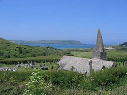 St Enodoc Church | |
 Perceval Institute | |
 St Minver Location within Cornwall | |
| Population | 2,393 (Civil Parish, 2011) |
| OS grid reference | SW 965 771 |
| Unitary authority | |
| Ceremonial county | |
| Region | |
| Country | England |
| Sovereign state | United Kingdom |
| Post town | WADEBRIDGE |
| Postcode district | PL27 |
| Dialling code | 01208 |
| Police | Devon and Cornwall |
| Fire | Cornwall |
| Ambulance | South Western |
| UK Parliament | |
St Minver (Cornish : Sen Menvra) is the name of an ecclesiastical parish, a civil parish and a village in north Cornwall, England, United Kingdom.
Contents
- Settlements
- Churches
- Quaker Meeting House and burial grounds
- Cornish wrestling
- References
- External links
The civil parish of St Minver is in Bodmin Registration District and is nominally divided into St Minver Highlands (to the north and east) and St Minver Lowlands (to the west).
The combined parish is bounded on the south and west by the estuary of the River Camel, on the north by the Atlantic coast, and on the east by the parishes of St Endellion and St Kew. [1] The population of the parish in the 2001 census was 2,474 (St Minver Highlands 1025; St Minver Lowlands 1449) decreasing to 2,393 at the 2011 census. [2]