
Aoraki / Mount Cook National Park is a national park located in the central-west of the South Island of New Zealand. It was established in October 1953 and takes its name from the highest mountain in New Zealand, Aoraki / Mount Cook. The area of the park is 707 km2 (273 sq mi), and it shares a border with Westland Tai Poutini National Park along the Main Divide of the Southern Alps. The national park consists of reserves that were established as early as 1885 to protect the area's significant landscape and vegetation. Glaciers cover 40% of the park, including the county's largest glacier, Haupapa / Tasman Glacier. In 1990, the park was included in the area designated as the Te Wāhipounamu World Heritage Site. The park is managed by the Department of Conservation (DOC) alongside Ngāi Tahu, the iwi who are mana whenua in the region.

Tasman District is a local government district in the northwest of the South Island of New Zealand. It borders the Canterbury Region, West Coast Region, Marlborough Region and Nelson City. It is administered by the Tasman District Council, a unitary authority, which sits at Richmond, with community boards serving outlying communities in Motueka and Golden Bay / Mohua. The city of Nelson has its own unitary authority separate from Tasman District, and together they comprise a single region in some contexts, but not for local government functions or resource management (planning) functions.

The Buller River is a river in the South Island of New Zealand. The Buller has the highest flow of any river in the country during floods, though it is only the 13th longest river; it runs for 177 km (110 mi) from Lake Rotoiti through the Buller Gorge and into the Tasman Sea near the town of Westport. A saddle at 710 m (2,330 ft) separates the Buller from the Motupiko River and that is divided from the Wairau River by a 695 m (2,280 ft) saddle, both aligned along the Alpine Fault, as is the top of the Buller valley.

Murchison is a town in the Tasman Region of the South Island of New Zealand. It is near the western end of the "Four Rivers Plain", at the confluence of the Buller River and the Mātakitaki River. The other two rivers are the Mangles River, and the Matiri River. It is a rural service town for the surrounding mixed farming district, approximately halfway between Westport and Nelson. Murchison was named after the Scottish geologist Roderick Murchison, one of the founders of the Royal Geographical Society.
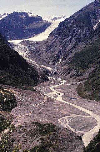
Fox Glacier is a 13-kilometre-long (8.1 mi) temperate maritime glacier located in Westland Tai Poutini National Park on the West Coast of New Zealand's South Island. Like nearby Franz Josef Glacier, Fox Glacier is one of the most accessible glaciers in the world, with a terminal face as low as 300 m above sea level, close to the village of Fox Glacier. It is a major tourist attraction and about 1000 people daily visit it during high tourist season.

Haupapa / Tasman Glacier is the largest glacier in New Zealand, and one of several large glaciers which flow south and east towards the Mackenzie Basin from the Southern Alps in New Zealand's South Island.

Tākaka is a small town situated at the southeastern end of Golden Bay, at the northern end of New Zealand's South Island, located on the lower reaches of the Tākaka River. State Highway 60 runs through Takaka and follows the river valley before climbing over Tākaka Hill, to Motueka linking Golden Bay with the more populated coast of Tasman Bay to the southeast. The town is served by Tākaka Aerodrome.

The Tasman River is an alpine braided river flowing through Canterbury, in New Zealand's South Island.
The Mōkihinui River is a river located on the West Coast of New Zealand's South Island, about 40 kilometres north of Westport. Meridian Energy had proposed the Mokihinui Hydro project on the river in 2007 but it was cancelled in May 2012. In 2019, it was announced that 64,400 ha of land in the Mōkihinui River catchment, including 15 km (9.3 mi) of river bed, would be added to Kahurangi National Park.
Young River is in the Otago region of the South Island of New Zealand. It lies within the Mount Aspiring National Park and feeds into the Makarora River 3 kilometres (2 mi) upriver from Makarora.

The Cobb Power Station is a hydroelectric facility on the Cobb River, in the Tasman District of New Zealand. The power station is located in Upper Tākaka, 112 km (70 mi) northwest of Nelson. Annual generation is approximately 190 gigawatt-hours (680 TJ). The initial stages of the construction of the station began as a privately-funded scheme in 1935, but the investor failed to raise the necessary capital. The national government took over building the station and the first power was produced in 1944, operating as a run-of-river station. A storage dam was completed in 1954. The resulting hydro lake is the highest in the country and at 596 m (1,955 ft), the station has New Zealand's highest hydraulic head of any power station.
The 1929 Arthur's Pass earthquake occurred at on 9 March. The sparsely settled region around Arthur's Pass of the Southern Alps shook for four minutes. Tremors continued almost continuously until midnight and sporadic strong aftershocks were felt for several days.

The Anatoki River is a river of New Zealand. It is located in the Tasman Region, and is a tributary of the Tākaka River and is one of the country's steepest rivers. The river's name means cave of stone adzes. The river drains a catchment area of 101 km2 (39 sq mi) that is surrounded by the Haupiri, Douglas, Snowdon, Devil and Anatoki Ranges. Rainfall records in the catchment taken at an elevation of 1,300 m (4,300 ft) show that the 10 year return period storm brings 291 mm (11.5 in) of precipitation in 24 hours.
The 1929 Murchison earthquake occurred at 10:17 am on 17 June. It struck the Murchison region of the South Island, with an estimated magnitude of 7.3, and was felt throughout New Zealand. There were 17 deaths, mostly as a result of landslides triggered by the earthquake. The rumbling sound of the earthquake was loud enough to be heard at New Plymouth, more than 250 km (155 mi) away.
The Waingaro River is a river of the Tasman Region of New Zealand's South Island.

Golden Bay is a large shallow bay in New Zealand's Tasman District, near the northern tip of the South Island. An arm of the Tasman Sea, the bay lies northwest of Tasman Bay and Cook Strait. It is protected in the north by Farewell Spit, a 26 km long arm of fine golden sand that is the country's longest sandspit. The Aorere and Tākaka rivers are the major waterways to flow into the bay from the south and the west.

Rawhiti Cave, also known as Manson Cave, is a single large limestone cave in the hillside of the Dry Creek Valley 7 kilometres (4.3 mi) southeast of Tākaka on the South Island of New Zealand. It is referred to as Manson Cave in the NZ Topo Map, after owners in the early 20th century, however the cave is known as Rawhiti Cave locally, and on DoC information panels and in brochures.

East Tākaka is a settlement in the Tasman District of New Zealand. It is located in Golden Bay, 8 kilometres (5.0 mi) south of Tākaka.

The Wangapeka Track is a tramping track in the north-west of the South Island of New Zealand. It is one of the main tramping tracks in the Kahurangi National Park, a protected area managed by the Department of Conservation. The route traverses the southern end of the park, from the historic Wangapeka goldfields area west of Tapawera, to the coastal plains of the West Coast at Little Wanganui. The route is 59 km (37 mi) long, and crosses the Wangapeka and Little Wanganui saddles, each over 1,000 m (3,300 ft) in elevation. The track passes through the valleys of the Wangapeka River, Karamea River, Taipō River and Little Wanganui River. The majority of the track is in river valleys and under forest cover, with small sections in tussock land at Stag Flat and the Little Wanganui Saddle. It typically takes walkers 4–6 days to complete the route.
Newton River in the Tasman District ), flows west and then south for about 20 km (12 mi) from Mount Newton to the Buller River, 17 km (11 mi) west of Murchison. Near its mouth it is crossed by SH6 on a steel truss bridge with a 120 ft (37 m) main span and two 30 ft (9.1 m) side spans.


