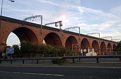
Stockport Viaduct

Last updated

Stockport Viaduct
Stockport Viaduct in 2012.jpg
Stockport Viaduct
Coordinates 53°24′33″N2°09′51″W / 53.4091°N 2.1642°W / 53.4091; -2.1642
Carries West Coast Main Line
Crosses River Mersey
Locale Stockport, Greater Manchester
Official nameStockport Viaduct
Owner Network Rail
Maintained by Network Rail
Heritage status Grade II* listed
Characteristics
Design Arch bridge
Material Brick
Total length547.2 m (598.4 yd)
Height111.1 ft (33.9 m) maximum
No. of spans22 [1]
Rail characteristics
No. of tracks 4
Track gauge 1,435 mm (4 ft 8+12 in)
Electrified 25 kV 50 Hz AC OHLE
History
Engineering design by George Watson Buck
Construction startMarch 1839 (March 1839) [2]
Construction endDecember 1840 (December 1840) [2]
Construction cost£72,000 [1]
OpenedAugust 1842 (August 1842) [1]
Location
Stockport Viaduct

Stockport Viaduct carries the West Coast Main Line across the valley of the River Mersey in Stockport, Greater Manchester, England (grid reference SJ89089030 ). It is one of the largest brick structures in the United Kingdom and a major structure of the early railway age. It is immediately north of Stockport railway station.

Contents

The viaduct was designed by George Watson Buck in consultation with the architect John Lowe for the Manchester and Birmingham Railway. Work began in March 1839 and despite its scale and flooding from the Mersey, the viaduct was completed in December 1840 and services commenced the same month. Roughly 11 million bricks were used in its construction; at the time of its completion, it was the world's largest viaduct and a major feat of engineering. The viaduct is 33.85 metres (111.1 ft) high. [3] [note 1] Since March 1975, Stockport Viaduct has been a Grade II* listed structure; [4] it remains one of the world's biggest brick structures. [3]

Several alterations have been made to the viaduct, in the late 1880s it was widened to accommodate four tracks by the London and North Western Railway. In the 1960s, overhead catenary lines were installed by British Rail for the West Coast Main Line electrification scheme. In the second half of the 20th century, the M60 motorway was built, passing through two of the viaduct's arches between Junction 1 (A5145 road) and Junction 27 (Portwood Roundabout). The viaduct has been subject to renovation and remedial repairs over the years.

History

Background and construction

Stockport Viaduct was built to carry the Manchester and Birmingham Railway across the valley of the River Mersey at Stockport. The viaduct was designed by the engineer George Watson Buck in consultation with the architect John Lowe. [1] On 31 October 1838, the company's directors met to choose contractors from tenders that had been submitted. [2] The contractors chosen were John Tomkinson and Samuel and John Holme and the work was overseen by the resident engineer W. Adams and subsequently by W.H. Perkins. [1]

The plans for the viaduct differed from what was actually constructed, particularly in terms of its height. It was planned to be 23.8 metres (78 ft) high, but raised after it was realised that it would save £50,000 across the whole line. [2] The viaduct stands 33.8 metres (111 ft) above the bed of the Mersey, is 546.2 metres (1,792 ft) long and as built, was 9.4 metres (31 ft) wide. The engine house of Wear Mill, built in 1831, was on the line of the railway and the viaduct was built over it by constructing the piers on either side of it. [1]

On 10 March 1839, the viaduct's foundation stone was laid. [2] At the peak of construction, around 600 workers were employed in shifts, working day and night. It took 21 months to complete using around 11 million common bricks and 11,300 cubic metres (400,000 cu ft) of stone and cost £72,000. [1] [4] [5] Construction was hindered by floods in the Mersey which washed away the viaduct's centres on a couple of occasions early on in the work. On 21 December 1840, the final stone was set, marking its completion. [2] Scaffolding and centring used to build the arches were reused in the construction of the Dane Viaduct 15 miles (24 km) to the south. [1]

The viaduct comprises 22 semi-circular arches with spans of 19.2 metres (63 ft) flanked by a pair of abutment arches of 5.5-metre (18 ft) span. The arch rings are 900 millimetres (35 in) thick. The arches and spandrels are built of red brick set in lime mortar with ashlar spring courses. The deck parapets are 2.2 metres (7 ft 3 in) high. The distance between the arch crowns and the top of the parapets is 3.6 metres (12 ft). The red-brick piers are 3 metres (9.8 ft) thick and 12.2 metres (40 ft) high. They are solid up to 7.9 metres (26 ft) above the springings above which they have 685-millimetre (27 in) thick walls filled with ballast. The piers at the abutments have rusticated facings. The original trackbed was 8.7 metres (29 ft) wide, ballasted with sandstone taken from cuttings along the railway. The track is drained via 100-millimetre (3.9 in) diameter iron pipes through the piers. [1]

Operational life

Stockport Viaduct illustrated circa 1854 Image taken from page 79 of 'Bradshaw's Hand-Book to the Manufacturing Districts of Great Britain ... Illustrated with ... county maps'.jpg
Stockport Viaduct illustrated circa 1854

The Manchester to Stockport line was officially opened on 4 June 1840, [6] but the viaduct was not completed until 21 December 1840. [1] On 16 July 1841, the first train crossed the viaduct and it opened to rail traffic on 10 August 1842, enabling through services to Crewe and facilitating travel to London. [1] [7]

The first section of the Manchester and Birmingham line, from a temporary station in Travis Street, Manchester, to a temporary station at Heaton Norris on the Lancashire side of the Stockport Viaduct, opened on 4 June 1840 and carried nearly 2,000 passengers per day in the second half of that year. On 10 May 1842, train services were extended from Heaton Norris to Sandbach when Store Street in Manchester opened.

Work to widen the viaduct, circa 1888 Stockport Viaduct widening 1887-89.jpg
Work to widen the viaduct, circa 1888

Between 1887 and 1889, the viaduct was widened by approximately 6.8 metres (22 ft) along one side to accommodate two more tracks. [1] The London and North Western Railway, formed in 1846, required a continuous four-track configuration along the route to enable express services to overtake slower trains. The engineer Francis Stephenson retained the original dimensions and form of the viaduct when it was widened. [1] Additional tapered piers were built and another abutment arch to carry the wider deck was added at the Stockport end. The work was carried out by manual labour. [1]

In 1929, the arch above Heaton Lane was repaired after several bricks fell from the soffit. [1] The degraded condition of the brickwork was attributed to unseasonably high temperatures in the summers of 1915–1917 which had caused raising in the viaduct's track and parapet. Areas of damaged brickwork were replaced with reinforced concrete, the arch was re-grouted and steel rails were installed across the affected area. [1]

Street-level view of Stockport Viaduct. Note the presence of the overhead electrification gantries. Stockportviaduct.jpg
Street-level view of Stockport Viaduct. Note the presence of the overhead electrification gantries.

In the 1960s, overhead catenary lines were installed for the West Coast Main Line electrification scheme. [8] On 10 March 1975, the viaduct was granted Grade II* listed building status. [4] In 1989, the viaduct was restored at an estimated cost of £3 million. The brickwork was cleaned to improve its appearance, [1] and floodlights were installed to illuminate it at night time. [7]

In the second half of the 20th century, the M60 motorway around Manchester was constructed. [1] Its three-lane carriageways pass through two of the viaduct's arches between Junction 1 (A5145 road) and Junction 27 (Portwood Roundabout). [1]

In late 2007, Stockport Metropolitan Borough Council objected to service changes by CrossCountry which proposed to reduce the number of Manchester to Birmingham trains stopping at Stockport by 50 per cent. Councillor David White claimed that an 1840 Act of Parliament guaranteed that all trains passing over the viaduct had to stop at Stockport station. [9] In response, Labour MP Andrew Gwynne stated:

"Sadly no such Act of Parliament exists, although it is common currency in the town that it does. I made enquiries with the House of Commons Library and the Parliamentary Archives back at the time some intercity trains stopped using Stockport. It appears it is purely an urban myth." [10]

In 2011, the viaduct was refurbished by Network Rail but by 2018, its condition had declined, limestone staining (likely caused by failing waterproofing measures) and graffiti were present in multiple areas; local authorities were reportedly considering legal action to compel Network Rail to address its condition. [11] [12]

The viaduct is mentioned in the introduction to the Northern Mill Towns in Elizabeth Gaskell's North and South . It has been portrayed in several works by L.S. Lowry. [1]

1948 rail accident

An accident on the viaduct occurred on 30 November 1948 at 19:40 when, in darkness and thick fog, a Buxton train ran into the back of a Crewe and Disley train that was stopped at the signal at the south end of the viaduct waiting for a platform. Although the collision was at 10–15 mph, because of the inertial mass of four locomotives the last (11th) coach of the Crewe–Disley service telescoped into the 10th carriage. Five people were killed and 27 were seriously injured. The impact took place in approximately the centre of the viaduct. The inspector attributed the cause to the driver of the lead engine of the Buxton train, which was stopped at a signal just south of Heaton Norris railway station. He misinterpreted a shout from the assistant porter as having been from the guard giving permission to proceed, which the guard should have obtained from the signal box under Rule 55, as the signal was not visible in the dense fog. The train passed the signal at danger. [13]

See also

Notes

  1. c.f. Göltzsch Viaduct in eastern Germany.

Related Research Articles

<span class="mw-page-title-main">Manchester Piccadilly station</span> Railway station in Manchester, England

Manchester Piccadilly is the principal railway station in Manchester, England. Opened as Store Street in 1842, it was renamed Manchester London Road in 1847 and became Manchester Piccadilly in 1960. Located to the south-east of Manchester city centre, it hosts long-distance intercity and cross-country services to national destinations including London, Birmingham, Nottingham, Glasgow, Edinburgh, Cardiff, Bristol, Exeter, Plymouth, Reading, Southampton and Bournemouth; regional services to destinations in Northern England including Liverpool, Leeds, Sheffield, Newcastle and York; and local commuter services around Greater Manchester. It is one of 19 major stations managed by Network Rail. The station has 14 platforms: 12 terminal and two through platforms. Piccadilly is also a major interchange with the Metrolink light rail system with two tram platforms in its undercroft.

The Manchester and Birmingham Railway was built between Manchester and Crewe and opened in stages from 1840. Between Crewe and Birmingham, trains were worked by the Grand Junction Railway. The M&BR was merged into the London and North Western Railway in 1846.

Heaton Norris is a suburb of the Metropolitan Borough of Stockport, Greater Manchester, England. It is part of the Four Heatons, and neighbours Heaton Chapel, Heaton Mersey and Heaton Moor. Within the boundaries of the historic county of Lancashire, in 1835 part of Heaton Norris was annexed to the County Borough of Stockport, with Heaton Chapel and Heaton Moor following in 1894 and the remnant in 1913.

<span class="mw-page-title-main">Stockport railway station</span> Railway station in Stockport, Greater Manchester, England

Stockport railway station in Stockport, Greater Manchester, England, is 8 miles south-east of Manchester Piccadilly on the West Coast Main Line to London Euston.

<span class="mw-page-title-main">Runcorn Railway Bridge</span> Bridge in northwest England

The Runcorn Railway Bridge, Ethelfleda Bridge or Britannia Bridge crosses the River Mersey at Runcorn Gap between Runcorn and Widnes in Cheshire, England. It is alongside the Silver Jubilee Bridge. The bridge is recorded in the National Heritage List for England as a Grade II* Listed building.

<span class="mw-page-title-main">Cheadle Hulme railway station</span> Railway station in Cheadle Hulme, Greater Manchester

Cheadle Hulme railway station is a station in Cheadle Hulme, Greater Manchester, England. It is operated by Northern Trains.

<span class="mw-page-title-main">Gatehampton Railway Bridge</span> Bridge in Lower Basildon, Berkshire

Gatehampton Railway Bridge, otherwise referred to as Gatehampton Viaduct, is a railway bridge carrying the Great Western Main Line over the River Thames in Lower Basildon, Berkshire, England. It takes the line between the stations at Goring and Streatley and Pangbourne, and crosses the Thames on the reach between Whitchurch Lock and Goring Lock.

<span class="mw-page-title-main">Sankey Viaduct</span> Bridge

The Sankey Viaduct is a railway viaduct in North West England. It is a designated Grade I listed building and has been described as being "the earliest major railway viaduct in the world".

<span class="mw-page-title-main">Welland Viaduct</span> Viaduct crossing the valley of the River Welland in Rutland, England

Welland Viaduct, Harringworth Viaduct or Seaton Viaduct, crosses the valley of the River Welland between Harringworth in Northamptonshire and Seaton in Rutland, England.

<span class="mw-page-title-main">Landore Viaduct</span>

The Landore viaduct is a railway viaduct over the Swansea valley and the River Tawe at Landore in south Wales. It provides a link between Swansea city center and the West Wales Line to the South Wales Main Line. The valley crossing provides a panoramic view of Landore, Kilvey Hill, the Liberty Stadium and the Swansea Enterprise Park.

<span class="mw-page-title-main">Ouse Valley Viaduct</span> Viaduct carrying the London-Brighton Railway Line over the River Ouse in Sussex, UK

The Ouse Valley Viaduct carries the London-Brighton Railway Line over the River Ouse in Sussex. It is located to the north of Haywards Heath and the south of Balcombe. Known for its ornate design, the structure has been described as "probably the most elegant viaduct in Britain."

<span class="mw-page-title-main">London Road viaduct</span> Bridge in Brighton, UK

The London Road Viaduct is a brick railway viaduct in Brighton, part of the city of Brighton and Hove in East Sussex, England. It carries the East Coastway Line between Brighton and London Road railway stations. Built in the 1840s for the Brighton, Lewes and Hastings Railway by the locomotive engineer and railway architect John Urpeth Rastrick, the sharply curving structure has 27 arches and about 10 million bricks. It is still in constant use, and is listed at Grade II* for its historical and architectural significance.

<span class="mw-page-title-main">River Irwell Railway Bridge</span> Bridge in Manchester, England

The River Irwell Railway Bridge was built for the Liverpool & Manchester Railway (L&MR), the world's first passenger railway which used only steam locomotives and operated as a scheduled service, near Water Street in Manchester, England. The stone railway bridge, built in 1830 by George Stephenson, was part of Liverpool Road railway station. The bridge was designated a Grade I listed building on 20 June 1988.

<span class="mw-page-title-main">Dinting Viaduct</span> Bridge in Glossop, Derbyshire

Dinting Viaduct is a 19th-century railway viaduct in Glossopdale in Derbyshire, England, that carries the Glossop Line over a valley at the village of Dinting. It crosses the Glossop Brook and the A57 road between Manchester and Sheffield.

<span class="mw-page-title-main">Bargo railway viaduct</span> Bridge in New South Wales, Australia

The Bargo Railway Viaduct is a heritage-listed railway viaduct over the Bargo River located on the Main South railway approximately 96 kilometres (60 mi) from Central, in the south-western Sydney settlement of Bargo in the Wollondilly Shire local government area of New South Wales, Australia. The viaduct was designed by New South Wales Government Railways and built in 1919. It is also known as Bargo River Railway Viaduct. The property is owned by Transport Asset Holding Entity, an agency of the Government of New South Wales. It was added to the New South Wales State Heritage Register on 2 April 1999.

<span class="mw-page-title-main">Stonequarry Creek railway viaduct, Picton</span> Bridge in New South Wales, Australia

Stonequarry Creek railway viaduct is a heritage-listed railway viaduct over the Stonequarry Creek located on the Main Southern railway in the south-western Sydney town of Picton in the Wollondilly Shire local government area of New South Wales, Australia. It was designed by John Whitton as the Engineer-in-Chief for Railways and was built from 1863 to 1867 by Murnin and Brown. It is also known as Stonequarry Creek Railway Viaduct and Picton railway viaduct over Stonequarry Creek. The property is owned by Transport Asset Holding Entity, an agency of the Government of New South Wales. It was added to the New South Wales State Heritage Register on 2 April 1999.

<span class="mw-page-title-main">Bowenfels rail viaducts</span> Bridge in New South Wales, Australia

The Bowenfels rail viaducts are a series of heritage-listed railway viaducts and railway bridges over Farmers Creek on the Main Western Line in Bowenfels, City of Lithgow, New South Wales, Australia. It was designed in two stages, by John Whitton as the Engineer-in-Chief for Railways, in 1870; and by engineering staff of New South Wales Government Railways in 1921; and was built from 1870 to 1921. It is also known as Farmers Creek viaducts. The property is owned by Transport Asset Holding Entity, an agency of the Government of New South Wales. It was added to the New South Wales State Heritage Register on 2 April 1999. The viaduct are located approximately 159 kilometres (99 mi) west of Central railway station.

<span class="mw-page-title-main">Glebe and Wentworth Park railway viaducts</span> Bridge in New South Wales, Australia

The Glebe and Wentworth Park railway viaducts are a series of two heritage-listed railway bridges and arch viaducts that carry the Inner West Light Rail across Wentworth Park, Jubilee Park, and Johnstons Creek in the inner western Sydney suburb of Glebe in the City of Sydney local government area of New South Wales, Australia. They were designed by the New South Wales Government Railways and built from 1892 to 1922 by day labour. They are also known as Wentworth Park Viaduct, Jubilee Park Viaduct and Glebe Viaducts. The viaducts were added to the New South Wales State Heritage Register on 2 April 1999.

<span class="mw-page-title-main">Chirk Viaduct</span> Railway viaduct between England and Wales

The Chirk Viaduct is a Grade II* listed railway viaduct over the River Ceiriog between England and Wales. The viaduct carries the Shrewsbury–Chester line from the Welsh town of Chirk in historic Denbighshire from the north to the English village of Chirk Bank in Weston Rhyn, Shropshire to the south. Chirk Aqueduct lies parallel to the viaduct's east.

<span class="mw-page-title-main">Wolverton Viaduct</span> Bridge in Milton Keynes, England

Wolverton Viaduct is a railway bridge carrying the West Coast Main Line over the River Great Ouse to the north of Wolverton, part of the City of Milton Keynes, in south-eastern England. Built in 1837 for the London and Birmingham Railway under the supervision of Robert Stephenson, it is one of the largest and most notable structures on the route and is a grade II listed building.

References

  1. 1 2 3 4 5 6 7 8 9 10 11 12 13 14 15 16 17 18 19 20 "Stockport Viaduct". engineering-timelines.com. Retrieved 11 June 2018.
  2. 1 2 3 4 5 6 "Stockport (Edgeley) Viaduct Stockport". manchestervictorianarchitects.org.uk. Retrieved 15 March 2021.
  3. 1 2 Historic England. "Stockport Railway Viaduct (76880)". Research records (formerly PastScape). Retrieved 25 April 2008.
  4. 1 2 3 Historic England. "Stockport Viaduct (1356861)". National Heritage List for England . Retrieved 29 February 2008.
  5. "Edgeley Viaduct, Stockport, about 1890, Science and Society Picture Library". scienceandsociety.co.uk. Retrieved 15 March 2021.
  6. Whishaw, Francis (1842). The Railways of Great Britain and Ireland Practically Described. J. Weale. p. 306 via Google Books.
  7. 1 2 "Stockport Viaduct". Stockport Metropolitan Borough Council. Archived from the original on 13 March 2008. Retrieved 24 October 2008.
  8. Fairhurst, John Andrew. "Stockport Viaduct" . Retrieved 20 April 2008.
  9. Morley, Victoria (14 November 2007). "Stop! Trains just 'passing through'". Stockport Express. M.E.N. Media.
  10. Gwynne, Andrew (29 August 2012). "Rail services to London via Stockport to be retained – MP" . Retrieved 23 March 2014.
  11. Scapens, Alan (6 February 2018). "Legal action could be taken against Network Rail over state of Stockport Viaduct". Manchester Evening News.
  12. Scapens, Alan (24 April 2018). "Stockport Viaduct is filthy and badly needs waterproofing. But it's not going to happen any time soon..." Manchester Evening News.
  13. "Report on the Collision which occurred on 30 November 1948, at Stockport in the London Midland Region British Railways". railwaysarchive.co.uk. 10 March 1949. Retrieved 7 August 2013.