
Ohio is a town in Herkimer County, New York, United States. The population was 1,002 at the 2010 census. The town is named after the state of Ohio. The town is in the northern part of the county and northeast of Utica. Part of Ohio is within the Adirondack Park.

The Mohawk River is a 149-mile-long (240 km) river in the U.S. state of New York. It is the largest tributary of the Hudson River. The Mohawk flows into the Hudson in Cohoes, New York, a few miles north of the city of Albany. The river is named for the Mohawk Nation of the Iroquois Confederacy. It is a major waterway in north-central New York.

The Cumberland River is a major waterway of the Southern United States. The 688-mile-long (1,107 km) river drains almost 18,000 square miles (47,000 km2) of southern Kentucky and north-central Tennessee. The river flows generally west from a source in the Appalachian Mountains to its confluence with the Ohio River near Paducah, Kentucky, and the mouth of the Tennessee River. Major tributaries include the Obey, Caney Fork, Stones, and Red rivers.

Lake Minnewanka is a glacial lake located in the eastern area of Banff National Park in Canada, about five kilometres northeast of the Banff townsite. The lake is 21 km (13 mi) long and 142 m (466 ft) deep, making it the 2nd longest lake in the mountain parks of the Canadian Rockies.

The Grasse River or Grass River is a 73-mile-long (117 km) river in northern New York, in the United States. The river mainly flows northeast from the foothills of the Adirondack Mountains into the St. Lawrence Valley, making up what is known as the greater St. Lawrence River Drainage Basin along with other tributaries such as the Oswegatchie and Raquette rivers.

Cumberland Mountain State Park is a state park in Cumberland County, Tennessee, in the southeastern United States. The park consists of 1,720 acres (7.0 km2) situated around Byrd Lake, a man-made lake created by the impoundment of Byrd Creek in the 1930s. The park is set amidst an environmental microcosm of the Cumberland Plateau and provides numerous recreational activities, including an 18-hole Bear Trace golf course.

The Delaware Water Gap National Recreation Area is a 70,000 acres (28,000 ha) protected area designated a National Recreation Area administered by the U.S. Department of the Interior's National Park Service. It is located along the middle section of the Delaware River in New Jersey and Pennsylvania stretching from the Delaware Water Gap northward in New Jersey to the state line near Port Jervis, New York, and in Pennsylvania to the outskirts of Milford. A 40-mile (64 km) section of the Delaware River, entirely within the National Recreation Area, has been granted protected status as the Middle Delaware National Scenic River under the National Wild and Scenic Rivers System and is also administered by the National Park Service. This section of the river is the core of the historical Minisink region.
Winnisook Lake is an artificial lake located in Oliverea, New York, United States. It is the source of Esopus Creek and the highest lake in the Catskill Mountains at 2,660 feet (810 m) above sea level.

The Ashokan Reservoir is a reservoir in Ulster County, New York. The reservoir is in the eastern end of the Catskill Park, and is one of several in the region created to provide the City of New York with water. It is the city's deepest reservoir, 190 feet (58 m) deep near the dam at the former site of Bishop Falls.
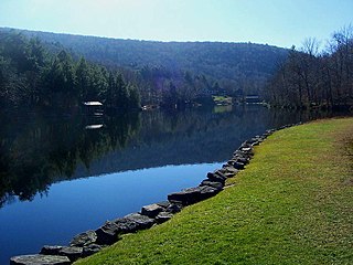
Popolopen is the name of several related landmarks mainly within the Hudson Highlands of Orange County, New York. These include a mountain, Popolopen Torne—or simply "The Torne", and a short and steep-sided nearby valley officially called Hell Hole, but often Popolopen Gorge. Popolopen Creek runs through this valley. The Popolopen Bridge spans its mouth at the Hudson River and is crossed by Route 9W. Popolopen Lake feeds the headwaters of its namesake creek. Despite local usage, the United States Board on Geographical Names recognizes only the lake, creek and bridge as bearing the name "Popolopen."

The Schoharie Reservoir is a reservoir in the Catskill Mountains of New York State that was created to be one of 19 reservoirs that supplies New York City with water. It was created by impounding Schoharie Creek. Portions of it lie in the towns of Conesville and Gilboa in Schoharie County, Roxbury in Delaware County, and Prattsville in Greene County.

The Kensico Reservoir is a reservoir located in the towns of Armonk, Harrison and Valhalla, New York. It was formed by the old earth and gravel dam, built in 1885, which impounded waters from the Bronx and Byram rivers, and supplied about 18 million gallons daily. The construction of a new masonry dam in 1915, replaced the old dam, and expanded the water supply by bringing water from the Catskill Mountains over a distance of more than 100 miles. It is about 3 miles (5 km) north of downtown White Plains, New York, and about 15 miles (24 km) north of New York City. The reservoir serves mainly to store the waters received from the Catskill Mountains west of the Hudson River. Along with the West Branch Reservoir and Boyds Corner Reservoir, it is one of only three reservoirs within the Catskill/Delaware system outside the Catskill Mountains region.
Stone Valley Recreation Area is an outdoor recreational and educational facility operated by The Pennsylvania State University. It is located in Huntingdon County near the village of Mooresville. The 700-acre (2.8 km2) property is located over the mountain from the village of Pine Grove Mills, Pennsylvania along Shaver's Creek. Hiking and fishing are among the activities available to visitors.

Malampuzha Dam is the largest reservoir in Kerala, located near Palakkad, in the state of Kerala in South India, built post independence by the then Madras state. Situated in the scenic hills of the Western Ghats in the background it is a combination of a masonry dam with a length of 1,849 metres and an earthen dam with a length of 220 metres. The dam is 355 feet high and crosses the Malampuzha River, a tributary of Bharathappuzha, Kerala's second longest river. There is a network of two canal systems that serve the dam's reservoir of 42,090 hectares.

Banasura Sagar Dam, which impounds the Karamanathodu tributary of the Kabini River, is part of the Indian Banasurasagar Project consisting of a dam and a canal project started in 1979. The goal of the project is to support the Kakkayam Hydro electric power project and satisfy the demand for irrigation and drinking water in a region known to have water shortages in seasonal dry periods.

Cove Lake State Park is a state park in Campbell County, Tennessee, in the southeastern United States. The park consists of 673 acres (2.72 km2) situated around Cove Lake, an impoundment of Cove Creek created by the completion of Caryville Dam in 1936. The park's location is adjacent to the town of Caryville and just west of Jacksboro.
Beacon Reservoir supplies water to the city of the same name in Dutchess County, New York, United States. It is located at 1,285 feet above sea level in a hollow between Beacon Mountain and Scofield Ridge, in the neighboring Town of Fishkill, very close to the Putnam County line. It was created in 1922 by damming Dry Brook, a tributary of Fishkill Creek.

The Cedar River is a 38.5-mile-long (62.0 km) river in the central Adirondacks, in Hamilton County, New York. It rises at the outlet of Cedar Lake in the town of Arietta and flows northeast into the town of Lake Pleasant, where it passes through the Cedar River Flow. Continuing northeast and east, it passes through the town of Indian Lake and remote corners of the towns of Minerva and Newcomb to join the Hudson River northeast of the hamlet of Indian Lake. The Northville-Placid Trail goes past the Cedar Lakes and along the Cedar River to the Flow.

The Minisink or Minisink Valley is a loosely defined geographic region of the Upper Delaware River valley in northwestern New Jersey, northeastern Pennsylvania and New York.
Stone Quarry Hill is a mountain in the Central New York region of New York. It is located northwest of East Worcester, New York.


