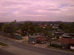
Subang, Selangor

Last updated
Subang
Subang, Mah Seng - panoramio - affnan.jpg
West Malaysia location map.svg
Red pog.svg
Subang
Location in Peninsular Malaysia
Coordinates: 3°9′1.75″N101°31′52.15″E / 3.1504861°N 101.5311528°E / 3.1504861; 101.5311528
Country Malaysia
State Selangor
Area
  Total200 km2 (80 sq mi)
Time zone UTC+8 (MST)
Postcode
40150
40160
47200
Calling code +603-78, +603-61

Subang is a township in Petaling District, Selangor, Malaysia. It is located about 17 km west of downtown Kuala Lumpur.

Contents

It is home to the Sultan Abdul Aziz Shah Airport (Subang Skypark), the former international airport of Kuala Lumpur. The airport now serves domestic flights, as well as cargo and private aviation.

Geography

Subang town falls within the local government area of the Shah Alam City Council (MBSA), corresponding to sections U3, U6 and U7. Clockwise from west to east, it is surrounded by Bukit Jelutong (Shah Alam), Sungai Buloh as well as the townships of Kwasa Damansara, Kota Damansara, Bandar Utama, Ara Damansara and Kelana Jaya (Petaling Jaya).

Subdivisions

Residential areas

As there are many golf courses nearby such as Glenmarie Golf and Country Club, Subang National Golf Club and it is home to the renowned Saujana Golf and Country Club, it is a strategic location for the premier neighbourhoods. These neighbourhoods include a range of houses from luxurious condominiums to villas, semi-detached and bungalows.

  • Amaya Saujana
  • Serai Saujana
  • Lake View Saujana
  • Glenhill Saujana
  • Maplewoods Saujana
  • Bunga Raya Condominium

Economy

Subang town, being home to the Subang Airport, houses the headquarters of Malaysia Airlines, the Malaysian flag carrier, as well as its low-cost subsidiary Firefly. The complex is across the highway from the airport terminal.

Airbus has a maintenance centre just south of the Malaysia Airlines compound. [1]

West of the airport runway, there is a small industrial area, along the road to the Royal Malaysian Air Force base. [2]

The main commercial area of Subang town is in Taman Subang Perdana, containing several shoplots, located just to the north of the airport runway. [3]

Transportation

Malaysia Airlines head office MHHeadoffice0.jpg
Malaysia Airlines head office

Air

Subang is home to the Sultan Abdul Aziz Shah Airport, a.k.a. Subang Skypark( IATA : SZB). It was Malaysia's principal international airport from 1965 to 1998, when it was replaced by the Kuala Lumpur International Airport in Sepang region. The airport still serves domestic flights and limited international flights by Firefly and Malindo Air. Private charter flights provided by Berjaya Air are also available.

The Subang Airport is also a major air cargo hub, operated by Raya Airways.

Rail and bus

Terminal Skypark Komuter station, on the KTM Komuter KL Sentral-Terminal Skypark Line, designed to connect Subang Airport to KL Sentral, is the main railway station in the area.

Rapid KL has 5 bus routes serving Subang town:

Car

Subang town is mainly served by the Federal Route 15, which was built as a feeder road for the Subang Airport. The highway links Sungai Buloh in the north to Subang Jaya in the south.

The Guthrie toll road runs through the western border of Subang town.

Indirectly, the PLUS toll road serves Subang town with an interchange with national highway 15 at exit 104 . The exit is next to Ara Damansara LRT station.

Education

Japanese School of Kuala Lumpur JapaneseSchoolKLMalaysia.jpg
Japanese School of Kuala Lumpur

The Japanese School of Kuala Lumpur is located on the grounds of the Saujana Golf and Country Club in Subang. [4]

Weather

Subang is considered as the most thunderous place in Malaysia. According to Malaysian Meteorological Department:-

Politics

Subang town falls within the Sungai Buloh parliamentary constituency, currently represented by Sivarasa Rasiah (PH-PKR).

On the state level, Subang town is within the borders of the Kota Damansara state constituency. It is currently held by Shatiri Mansor (PH-PKR).

Related Research Articles

<span class="mw-page-title-main">Shah Alam</span> City and state capital in Selangor, Malaysia

Shah Alam is a city and the state capital of Selangor, Malaysia and situated within the Petaling District and a small portion of the neighbouring Klang District. Shah Alam replaced Kuala Lumpur as the capital city of the state of Selangor in 1978 due to Kuala Lumpur's incorporation into a Federal Territory in 1974. Shah Alam was the first planned city in Malaysia after independence from Britain in 1957.

<span class="mw-page-title-main">Selangor</span> State of Malaysia

Selangor, also known by the Arabic honorific Darul Ehsan, or "Abode of Sincerity", is one of the 13 states of Malaysia. It is on the west coast of Peninsular Malaysia and is bordered by Perak to the north, Pahang to the east, Negeri Sembilan to the south, and the Strait of Malacca to the west. Selangor surrounds the federal territories of Kuala Lumpur and Putrajaya, both of which were previously part of it. Selangor has diverse tropical rainforests and an equatorial climate. The state's mountain ranges belong to the Titiwangsa Mountains, which is part of the Tenasserim Hills that covers southern Myanmar, southern Thailand and Peninsular Malaysia, with Mount Semangkok as the highest point in the state.

<span class="mw-page-title-main">Sultan Abdul Aziz Shah Airport</span> Airport in Subang, Selangor, Malaysia

Sultan Abdul Aziz Shah Airport — formerly Subang International Airport/Kuala Lumpur International Airport, often called Subang Airport — is an airport located in Subang, Petaling District, Selangor, Malaysia.

<span class="mw-page-title-main">Petaling Jaya</span> City in Selangor, Malaysia

Petaling Jaya, colloquially referred to as "PJ", is a city in Petaling District, in the state of Selangor, Malaysia. Originally developed as a satellite township for Kuala Lumpur, the capital of Malaysia, it is part of the Greater Kuala Lumpur area. Petaling Jaya was granted city status on 20 June 2006. It has an area of approximately 97.2 square kilometres (37.5 sq mi).

<span class="mw-page-title-main">Rapid KL</span> Public transportation system in Malaysia

Rapid KL is a public transportation system owned by Prasarana Malaysia and operated by its subsidiaries Rapid Rail and Rapid Bus. The acronym stands for Rangkaian Pengangkutan Integrasi Deras Kuala Lumpur, which translates to Kuala Lumpur Rapid Integrated Transport Network in the Malay language. Rapid KL, with its 204.1 km (126.8 mi) of metro railway and 5.6 km (3.5 mi) of BRT carriageway, is part of the Klang Valley Integrated Transit System, operating throughout Kuala Lumpur and Selangor's satellite cities in the Klang Valley area.

<span class="mw-page-title-main">Sungai Buloh</span> Place in Selangor, Malaysia

Sungai Buloh, or Sungei Buloh, is a town, a mukim (commune) and a parliamentary constituency in the northern part of Petaling District, Selangor, Malaysia. The name itself means bamboo river in the Malay language. It is located 16 km NW of downtown Kuala Lumpur and 8 km north of the Subang Airport, along the Kuala Selangor highway.

Malaysian National Projects are major national and giant projects which are important in the development of Malaysia.

<span class="mw-page-title-main">Kota Damansara</span> Place in Selangor, Malaysia

Kota Damansara is an affluent township located in Petaling Jaya, Petaling District, Selangor, Malaysia. It is a township spread across 4,000 acres (1,600 ha).

<span class="mw-page-title-main">Puchong</span> Town in Selangor, Malaysia

Puchong is a major town and a parliamentary constituency in the Petaling District, Selangor, Malaysia.

Transport in Greater Kuala Lumpur includes a road network, a railway network, airports, and other modes of public transport. Greater Kuala Lumpur is conterminous with the Klang Valley, an urban conglomeration consisting of the city of Kuala Lumpur, as well as surrounding towns and cities in the state of Selangor. The Klang Valley has the country's largest airport, the Kuala Lumpur International Airport (KLIA), as well as the country's largest intermodal transport hub and railway station, Kuala Lumpur Sentral.

<span class="mw-page-title-main">Sungai Buloh station</span> MRT, KTM and ETS integrate in Kuala Lumpur, Malaysia

The Sungai Buloh station is an integrated railway station serving the suburb of Sungai Buloh in Selangor, Malaysia, which is located to the northwest of Kuala Lumpur.

<span class="mw-page-title-main">Malaysia Federal Route 15</span> Road in Malaysia

Federal Route 15 is main federal road in the Klang Valley region, Selangor, Malaysia. The main link begins from Kampung Melayu Subang at Subang to Sultan Abdul Aziz Shah Airport (Skypark) and ends at Subang Jaya.

Damansara is a suburb in Petaling Jaya, a mukim in Petaling District, as well as a parliamentary constituency in Selangor, Malaysia. It is named after the Damansara River which flows nearby. It is one of the most densely populated areas in Malaysia. According to the 2000 Census of Malaysia, it was the second-largest district subdivision in Malaysia in terms of population with 453,420 residents.

<span class="mw-page-title-main">Kwasa Damansara</span> Town in Selangor, Malaysia

Kwasa Damansara is a new township located in the Sungai Buloh constituency of Selangor, Malaysia. Located 14 km northwest of Kuala Lumpur's central business district, it borders Kota Damansara to the south and Sungai Buloh to the north.

<span class="mw-page-title-main">Klang Valley Integrated Transit System</span> Rail transportation network in the Klang Valley

The Klang Valley Integrated Transit System is an integrated transport network that primarily serves the area of Klang Valley and Greater Kuala Lumpur. The system commenced operations in August 1995 with the introduction of commuter rail service on the existing rail between Kuala Lumpur and Rawang. The system have since expanded and currently consists of 11 fully operating rail lines in a radial formation; two commuter rail lines, six rapid transit lines, one bus rapid transit line and two airport rail links to the Kuala Lumpur International Airport's (KLIA) Terminal 1 and Terminal 2, and one temperarily suspended airport rail link to the Sultan Abdul Aziz Shah Airport. The system encompasses 528.4 kilometres (328.3 mi) of grade-separated railway with 197 operational stations.

<span class="mw-page-title-main">Kwasa Sentral MRT station</span> MRT station in Shah Alam, Selangor, Malaysia

The Kwasa Sentral station is a Mass Rapid Transit (MRT) station serving the future development project known as Kwasa Damansara in Section U4 of Shah Alam, Selangor, Malaysia. It is one of the stations of the MRT Kajang Line, formerly known as MRT Sungai Buloh–Kajang Line and was opened on 16 December 2016 under Phase One operations of the line.

<span class="mw-page-title-main">KL Sentral–Terminal Skypark Line</span> Railway line in Malaysia

The KTM KL Sentral–Terminal Skypark Line is a currently suspended limited express train service in Kuala Lumpur, Malaysia between Kuala Lumpur Sentral and Sultan Abdul Aziz Shah Airport. It is Malaysia's second airport rail link service, after the Express Rail Link system.

The following is an alphabetical list of articles related to Selangor.

References

  1. "Airbus in Malaysia". 19 July 2021. Retrieved 2 January 2022.
  2. "Pekan Subang Shah Alam, Selangor". Google Maps. Retrieved 2 January 2022.
  3. "Taman Subang Perdana 40150 Shah Alam, Selangor". Google Maps. Retrieved 2 January 2022.
  4. "School Outline Archived 2013-01-08 at the Wayback Machine ." Japanese School of Kuala Lumpur. Retrieved on January 13, 2015. "Saujana Resort Seksyen U2, 40150, Selangor Darul Ehsan, Malaysia"