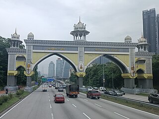
Shah Alam is a city and the state capital of Selangor, Malaysia and situated within the Petaling District and a small portion of the neighbouring Klang District. Shah Alam replaced Kuala Lumpur as the capital city of the state of Selangor in 1978 due to Kuala Lumpur's incorporation into a Federal Territory in 1974. Shah Alam was the first planned city in Malaysia after independence from Britain in 1957.
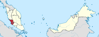
Selangor, also known by the Arabic honorific Darul Ehsan, or "Abode of Sincerity", is one of the 13 states of Malaysia. It is on the west coast of Peninsular Malaysia and is bordered by Perak to the north, Pahang to the east, Negeri Sembilan to the south, and the Strait of Malacca to the west. Selangor surrounds the federal territories of Kuala Lumpur and Putrajaya, both of which were previously part of it. Selangor has diverse tropical rainforests and an equatorial climate. The state's mountain ranges belong to the Titiwangsa Mountains, which is part of the Tenasserim Hills that covers southern Myanmar, southern Thailand and Peninsular Malaysia, with Mount Semangkok as the highest point in the state.

Sultan Abdul Aziz Shah Airport — formerly Subang International Airport/Kuala Lumpur International Airport, often called Subang Airport — is an airport located in Subang, Petaling District, Selangor, Malaysia.
Petaling Jaya, colloquially referred to as "PJ", is a city in Petaling District, in the state of Selangor, Malaysia. Originally developed as a satellite township for Kuala Lumpur, the capital of Malaysia, it is part of the Greater Kuala Lumpur area. Petaling Jaya was granted city status on 20 June 2006. It has an area of approximately 97.2 square kilometres (37.5 sq mi).
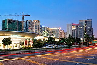
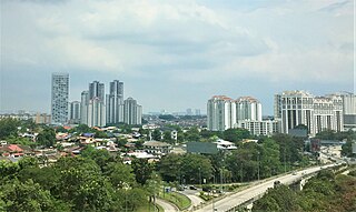
Subang Jaya is a city in Petaling District, Selangor, Malaysia. It comprises the southern third district of Petaling. It consists of the neighbourhoods from SS12 to SS19, UEP Subang Jaya (USJ), Putra Heights, Batu Tiga as well as PJS7, PJS9 and PJS11 of Bandar Sunway, the latter of which are partially jurisdictional within Petaling Jaya under the MBPJ. The city is governed by Subang Jaya City Council (MBSJ), which also governs other areas of the Petaling district, such as Puchong and Seri Kembangan. According to Subang Jaya City Council, Subang Jaya has a population of 968,930 in 2020, which makes it the sixth largest city in Malaysia by population.

UEP Subang Jaya is a major affluent township located in Subang Jaya, Selangor, Malaysia. It is located within the Mukim (sub-district) of Damansara in the district of Petaling.
Federal Highway is a Malaysian controlled-access highway connecting the capital city of Kuala Lumpur, and Klang, Selangor. The highway starts from Seputeh in Kuala Lumpur to Klang, Selangor. It is the busiest highway in Klang Valley during rush hour from/to Kuala Lumpur. The Federal Highway is coded as Federal Route 2.

The Damansara–Puchong ExpresswayDamansara–Puchong Expressway, abbreviated as LDP, is a 40.0-kilometre (24.9-mile) major controlled-access highway in the Petaling District of Selangor, Malaysia. The expressway runs in a north–south direction between Bandar Sri Damansara and Putra Permai, near Putrajaya, forming a major thoroughfare in the cities of Petaling Jaya and Puchong. A short east–west spur of the expressway connects Pusat Bandar Puchong to the suburb of UEP Subang Jaya.

Sungai Buloh, or Sungei Buloh, is a town, a mukim (commune) and a parliamentary constituency in the northern part of Petaling District, Selangor, Malaysia. The name itself means bamboo river in the Malay language. It is located 16 km NW of downtown Kuala Lumpur and 8 km north of the Subang Airport, along the Kuala Selangor highway.
Malaysian National Projects are major national and giant projects which are important in the development of Malaysia.

Kota Damansara is an affluent township located in Petaling Jaya, Petaling District, Selangor, Malaysia. It is a township spread across 4,000 acres (1,600 ha).

Subang is a township in Petaling District, Selangor, Malaysia. It is located about 17 km west of downtown Kuala Lumpur.

Ara Damansara is a residential township in Petaling Jaya, Petaling District, Selangor, Malaysia. It is located along Federal Route 15.
Transport in Greater Kuala Lumpur includes a road network, a railway network, airports, and other modes of public transport. Greater Kuala Lumpur is conterminous with the Klang Valley, an urban conglomeration consisting of the city of Kuala Lumpur, as well as surrounding towns and cities in the state of Selangor. The Klang Valley has the country's largest airport, the Kuala Lumpur International Airport (KLIA), as well as the country's largest intermodal transport hub and railway station, Kuala Lumpur Sentral.

The Subang Jaya station is a railway station located in SS16, Subang Jaya. It is served by the KTM Komuter Port Klang Line and Skypark Link, as well as the LRT Kelana Jaya Line.
Persiaran Kewajipan is a major road in Subang Jaya, Selangor, Malaysia. The road connects from central Subang Jaya through USJ to Putra Heights near the city's south interchange at Damansara–Puchong Expressway E11 (LDP). It is the busiest road in Subang Jaya during rush hour from/to Kuala Lumpur. This driveway is maintained by the Subang Jaya City Council or Majlis Bandaraya Subang Jaya (MBSJ).

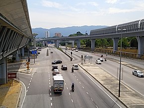
Subang–Kelana Jaya Link, Federal Route 15, is an elevated highway in Subang Jaya, Selangor, Malaysia. The highway connected from Persiaran Kewajipan to the Sultan Abdul Aziz Shah Airport Highway and Federal Highway. This elevated highway was constructed on 2005 by the Malaysian Public Works Department (JKR) and the main contractor Ahmad Zaki Resources Berhad (AZRB) and it was opened in 2009. It is the tallest elevated highway in Subang Jaya.
Sultan Abdul Aziz Shah Airport Road/Sultan Abdul Aziz Shah Airport Highway or Federal Route 15 is a major highway in Selangor, Malaysia that links the FT 2 Federal Highway (Malaysia) and Sungai Buloh towards the Sultan Abdul Aziz Shah Airport.
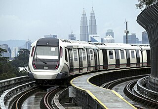
The Klang Valley Integrated Transit System is an integrated transport network that primarily serves the area of Klang Valley and Greater Kuala Lumpur. The system commenced operations in August 1995 with the introduction of commuter rail service on the existing rail between Kuala Lumpur and Rawang. The system have since expanded and currently consists of 11 fully operating rail lines in a radial formation; two commuter rail lines, six rapid transit lines, one bus rapid transit line and two airport rail links to the Kuala Lumpur International Airport's (KLIA) Terminal 1 and Terminal 2, and one temperarily suspended airport rail link to the Sultan Abdul Aziz Shah Airport. The system encompasses 528.4 kilometres (328.3 mi) of grade-separated railway with 197 operational stations.
The following is an alphabetical list of articles related to Selangor.