
Malaysian Federal Roads System, is the main national road network in Malaysia. All Federal Roads in Malaysia are under the purview of the Ministry of Works (MOW). According to the Ministerial Functions Act 1969, the MOW is responsible to plan, build and maintain all Federal Roads gazetted under the Federal Roads Act 1959. However, most of the Federal roads' projects were built and maintained by the Malaysian Public Works Department (JKR), which is also one of the implementing agencies under the MOW.
North Klang Straits Bypass, Federal Route 20, AH 141, is the main highway bypass to Port Klang in Klang, Selangor, Malaysia. Federal Route 20 became the backbone of the road system linking Sungai Rasau to Port Klang before being surpassed by the New North Klang Straits Bypass 30. Many cargo trucks travel along the highway daily.
The Federal Route 2 is a major east–west oriented federal highway in Malaysia. The 276.9 kilometres (172 mi) road connects Port Klang in Selangor to Kuantan Port in Pahang. The Federal Route 2 became the backbone of the road system linking the east and west coasts of Peninsula Malaysia before being surpassed by the East Coast Expressway E8.
Johor Bahru–Kota Tinggi Highway (Malay: Lebuhraya Johor Bahru–Kota Tinggi), Federal Route 3, also known as Tebrau Highway (Jalan Tebrau) and Jalan Kota Tinggi is a highway that encompasses Federal Route 3 in Johor Bahru, Malaysia. Part of Asian Highway Route AH18, the highway stretches from its southern end at Jalan Wong Ah Fook and Jalan Tun Abdul Razak in the metropolitan area of Johor Bahru to the northern end at the underpass flyover with North–South Expressway Southern Route and Johor Bahru Eastern Dispersal Link Expressway around Pandan. The stretch of Tebrau Highway after this continues as Jalan Pandan and Jalan Kota Tinggi respectively, beyond Pandan. The highway became the backbone of the Johor Bahru road system linking Pandan to the city centre, and to the Johor–Singapore Causeway, before being surpassed by the Johor Bahru Eastern Dispersal Link Expressway in 2012.

Federal Route 3 is a main federal road running along the east coast of Peninsula Malaysia. The 739 kilometres (459 mi) federal highway connects Rantau Panjang in Kelantan until Johor Bahru in Johor. The entire FT3 highway is gazetted as a part of the Asian Highway Network route 18.
Federal Route 5 is one of the three north–south oriented backbone federal roads running along the west coast of Peninsular Malaysia, Malaysia. The 655.85 kilometres (408 mi) federal highway runs from Jelapang, Perak in the north to Skudai, Johor in the south.
Tun Razak Highway, Federal Route 12(Lebuhraya Tun Razak), also known as Segamat-Kuantan Highway(Lebuhraya Segamat-Kuantan), Asian Highway Route 142, is a 146.8 kilometres (91 mi) federal highway running from the town of Segamat, Johor to Gambang before proceeding another 38 kilometres (24 mi) via Federal Route 2 to Gambang near Kuantan, Pahang. This two-lane federal road is named in honor of Tun Abdul Razak, Malaysia's second Prime Minister who was also known as Malaysia's Father of Development. The highway is part of the Asian Highway Network of route 142.
Federal Route 142, or Jalan Mufti Haji Khalil and Jalan Batu Berendam, is a federal road in Melaka, Malaysia. This route used to be known as Melaka State Route M1 on Melaka–Batu Berendam side before recommissioned as a federal road. The Kilometre Zero of the Federal Route 142 starts at Peringgit-Lebuh AMJ interchange.
Federal Route 76 is a federal highway in Kedah and Perak state, Malaysia. The 163.7-km federal highway serves as the main route from Perak and Kedah to the East–West Highway FT4, as well as the main route to Thailand via Keroh and Betong.

The Pan-Borneo Highway including the sections now known as the Pan Borneo Expressway, is a controlled-access highway on Borneo Island, connecting two Malaysian states, Sabah and Sarawak, with Brunei. The length of the entire highway is 2,083 kilometres (1,294 mi) for the Malaysian section, 168 kilometres (104 mi) for the Bruneian section.

Asian Highway 18 is a highway route included in Asian Highway Network, running from Hat Yai in Thailand to Johor Bahru, Malaysia. Route AH18 runs along main eastern coastal road in southern Thailand and also along Federal Route 3 of Malaysia.

Gambang is a town in Kuantan District, Pahang, Malaysia. It is located at a junction between Federal Route 2, MEC Highway and Tun Razak Highway. The Malaysia Electric Corporation (MEC) town and electrical appliances manufacturing factory is located here. It is accessible via the Gambang Interchange of the East Coast Expressway (ECE) East Coast Expressway.
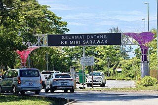
Miri–Baram Highway, Federal Route 1-82, also known as Jalan Kuala Baram-Sungai Tujuh, is a major highway in Miri Division, Sarawak, Malaysia. This highway is part of the Pan Borneo Highway AH 150.

Federal Route 22, Asian Highway Route AH150, is a 310-kilometre (193 mi) federal highway in Sabah, Malaysia, which is also a component of the larger Pan Borneo Highway network. It starts from Tamparuli and ends at Sandakan. The section running from Tamparuli to Ranau, which is known as Tamparuli-Ranau Highway, crosses the Crocker Range just to the south of Mount Kinabalu.
The Malaysian Expressway System is a network of national controlled-access expressways in Malaysia that forms the primary backbone network of Malaysian national highways. The network begins with the Tanjung Malim–Slim River tolled road which was opened to traffic on 16 March 1966, later North–South Expressway (NSE), and is being substantially developed. Malaysian toll road-expressways are built by private companies under the supervision of the government highway authority, Malaysian Highway Authority. While toll-free expressways are built by Malaysian Public Works Department or Jabatan Kerja Raya Malaysia (JKR) in Malay.

The Sabah section of the Federal Route 1, Asian Highway Route AH150, is a 428-km federal highway in Sabah, Malaysia, which is also a component of the larger Pan Borneo Highway network. The route was formed in 1996 during the merging of two former routes A1 and A2. The merging of the former routes formed an alternate route of Route 1 within the city of Kota Kinabalu. However, most maps still use the older route numbering scheme by referring to the northern section as A1 and the southern section as A2.
The Sarawak section of the Federal Route 1, Asian Highway Route AH 150, also known as Pan Borneo Highway Sarawak or Sarawak First Trunk Road, is a 1077-km federal highway in Sarawak, Malaysia, making the highway as the longest component of the Malaysian portion of the larger Pan Borneo Highway network. Construction of the highway began in 1965 after Sarawak became a member of the federation of Malaysia in 1963.

Asian Highway 141 is a highway that is part of Asian Highway Network. It was never signposted in Malaysia, although it is part of Asian Highway Network. It consists of New North Klang Straits Bypass New North Klang Straits Bypass, New Klang Valley Expressway, Duta–Ulu Klang Expressway, Kuala Lumpur Middle Ring Road 2 Federal Route 28(Greenwood–Gombak North Interchange), Kuala Lumpur–Karak Expressway, East Coast Expressway (Karak–Jabur) and Gebeng Bypass Federal Route 101.

Asian Highway 142AH142 is a highway that is part of Asian Highway Network. It was never signposted in Malaysia, although it is part of Asian Highway Network. It goes along the MEC Highway, Tun Razak Highway, and Federal Route 1.

