
Klang or Kelang, officially Royal City of Klang, is a city, royal city and former capital of the state of Selangor, Malaysia. It is located within the Klang District. It was the civil capital of Selangor in an earlier era prior to the emergence of Kuala Lumpur and the current capital, Shah Alam. Port of Port Klang, which is located in the Klang District, is the 12th busiest transshipment port and the 12th busiest container port in the world.
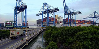
Port Klang is the principal port of Malaysia on the Strait of Malacca. Known during colonial times as Port Swettenham but renamed Port Klang in July 1972, it is the largest port in the country. It is located about 6 kilometres (3.7 mi) southwest of the town of Klang, and 38 kilometres (24 mi) southwest of Kuala Lumpur.
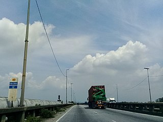
The Pulau Indah Expressway, Federal Route 181, is a countryside highway in Selangor, Malaysia. It connects Pandamaran from Shah Alam Expressway to West Port in Pulau Indah. This 17.7 km (11.0 mi) highway was opened to traffic in 1995, after four years of construction. Pulau Indah Expressway is a four-laned expressway, unlike the wider Shah Alam Expressway which has six lanes. Many cargo trucks travel along the highway daily. There are many accidents area along the highway.
Federal Route 5 is one of the three north–south oriented backbone federal roads running along the west coast of Peninsular Malaysia, Malaysia. The 655.85 kilometres (408 mi) federal highway runs from Jelapang, Perak in the north to Skudai, Johor in the south.
The South Klang Valley Expressway, or SKVESouth Klang Valley Expressway, is an expressway in the southern part of Klang Valley, Malaysia's most densely populated region. This 51.7 km (32.1 mi) dual-carriageway provides links to the booming towns in southern Klang Valley, including the country's administrative capital, Putrajaya. South Klang Valley Expressway is the fifth east–west-oriented expressway in the Klang Valley after the Federal Highway, the New Klang Valley Expressway (NKVE), the Kuala Lumpur–Kuala Selangor Expressway (LATAR) and the Shah Alam Expressway (KESAS).

Puchong is a major town and a parliamentary constituency in the Petaling District, in the state of Selangor, Malaysia. Bordering Kuala Lumpur, it is part of the Greater Kuala Lumpur area. It is bordered by Petaling Jaya in the north, Subang Jaya in the west, Cyberjaya and Putrajaya in the south, and Seri Kembangan in the east.

Taman Desa is a housing estate in south-western Kuala Lumpur, Malaysia under the postcode 58100. Located off the East–West Link Expressway and Jalan Klang Lama, Taman Desa falls under the Seputeh parliamentary constituency.

Pulau Indah is an island in Klang District, Selangor, Malaysia with a population of around 20,000 people overall. Malaysia's largest port, West Port, Port Klang, is on the island.
Jalan Ampang or Ampang Road is a major road in the Klang Valley region, Selangor and the Federal Territory of Kuala Lumpur, Malaysia. Built in the 1880s, it is one of the oldest roads in the Klang Valley. It is a main road to Ampang Jaya and is easily accessible from Jalan Tun Razak or Jalan Ulu Klang from the Hulu Kelang or Setapak direction. It is also accessible from Cheras through Jalan Shamelin, from Jalan Tun Razak through Jalan Kampung Pandan via Taman Cempaka, from Kampung Pandan through Jalan Kampung Pandan Dalam via Taman Nirwana, from the Kuala Lumpur Middle Ring Road 2 via Pandan Indah and Taman Kencana and from Hulu Langat town through the mountain pass. Wangsa Maju, Setapak, central Kuala Lumpur, Ampang Park and Salak South surround Ampang. Jalan Ampang became the backbone of the road system linking Ampang to Kuala Lumpur before being surpassed by the Ampang–Kuala Lumpur Elevated Highway (AKLEH) in 2001.
Transport in Greater Kuala Lumpur includes a road network, a railway network, airports, and other modes of public transport. Greater Kuala Lumpur is conterminous with the Klang Valley, an urban conglomeration consisting of the city of Kuala Lumpur, as well as surrounding towns and cities in the state of Selangor. The Klang Valley has Malaysia's largest airport, the Kuala Lumpur International Airport (KLIA), as well as the country's largest intermodal transport hub and railway station, Kuala Lumpur Sentral.

Tun Sambanthan station, is a Malaysian elevated monorail station that forms a part of the Kuala Lumpur Monorail line located in Kuala Lumpur and opened alongside the rest of the line and other adjoining monorail stations on 31 August 2003.

Jalan Klang Lama or Old Klang Road, Federal Route 2 is the oldest and the first major road in Kuala Lumpur, Malaysia. It was built before the Federal Highway was built in 1965. The road was constructed by the Federation of Malaya government from 1956 to 1959. The road was opened on 14 January 1959 by the Minister of Public Works, Sardon Jubir. This road passes through two towns, namely Sungai Way and Petaling Jaya.
Federal Route 190, consisting of Jalan Kota Raja, Jalan Sungai Kandis and Jalan Bukit Kemuning, is a federal road in Klang Valley region, Selangor, Malaysia. It is also a main route to Klang from Puchong, Kota Kemuning and Bukit Rimau.
Mid Valley City is a large mixed development in the Lembah Pantai ward in southwestern Kuala Lumpur, Malaysia. The development consists of The Gardens shopping mall, Mid Valley Megamall and three hotels, namely the Cititel Mid Valley, The Boulevard Hotel Kuala Lumpur and the Gardens Hotels and Residences.
Pulau Meranti is a village in Sepang District, Selangor, Malaysia.

Greater Kuala Lumpur is the geographical term that determines the boundaries of metropolitan Kuala Lumpur in Malaysia. Though similar to the term "Klang Valley", there remains a variation between the two. Ranked as the 30th-largest in Asia, it covers a total land size of 13,565.61 km2.

The Malaysian Expressway System is a network of national controlled-access expressways in Malaysia that forms the primary backbone network of Malaysian national highways. The network begins with the Tanjung Malim–Slim River tolled road which was opened to traffic on 16 March 1966, later North–South Expressway (NSE), and is being substantially developed. Malaysian toll road-expressways are built by private companies under the supervision of the government highway authority, Malaysian Highway Authority. While toll-free expressways are built by Malaysian Public Works Department or Jabatan Kerja Raya Malaysia (JKR) in Malay.
The Ministry of Transport, abbreviated MOT, is a ministry of the Government of Malaysia that is responsible for transport: road transport, civil aviation, road safety, port authority, maritime, air accident investigation, logistic and maritime safety. The ministry is headquartered in Putrajaya.

Taman Putra Perdana is a township in Dengkil sub-district, Sepang District, Selangor, Malaysia. Although the township's postcode is 47100 / 47120 / 47130, which gives it Puchong postal address, it is actually in the Sepang constituency of Selangor, administered by the Sepang Municipal Council (MPSepang). The township was developed by Kenshine Corporation in 1997.
The following is an alphabetical list of articles related to Selangor.


