
The Dwight D. Eisenhower National System of Interstate and Defense Highways, commonly known as the Interstate Highway System, is a network of controlled-access highways that forms part of the National Highway System in the United States. The system extends throughout the contiguous United States and has routes in Hawaii, Alaska, and Puerto Rico.

The United States Numbered Highway System is an integrated network of roads and highways numbered within a nationwide grid in the contiguous United States. As the designation and numbering of these highways were coordinated among the states, they are sometimes called Federal Highways, but the roadways were built and have always been maintained by state or local governments since their initial designation in 1926.
A state highway, state road, or state route is usually a road that is either numbered or maintained by a sub-national state or province. A road numbered by a state or province falls below numbered national highways in the hierarchy. Roads maintained by a state or province include both nationally numbered highways and un-numbered state highways. Depending on the state, "state highway" may be used for one meaning and "state road" or "state route" for the other.

Highways in Australia are generally high capacity roads managed by state and territory government agencies, though Australia's federal government contributes funding for important links between capital cities and major regional centres. Prior to European settlement, the earliest needs for trade and travel were met by narrow bush tracks, used by tribes of Indigenous Australians. The formal construction of roads began in 1788, after the founding of the colony of New South Wales, and a network of three major roads across the colony emerged by the 1820s. Similar road networks were established in the other colonies of Australia. Road construction programs in the early 19th century were generally underfunded, as they were dependent on government budgets, loans, and tolls; while there was a huge increase in road usage, due to the Australian gold rushes. Local government authorities, often known as Road Boards, were therefore established to be primarily responsible for funding and undertaking road construction and maintenance. The early 1900s saw both the increasingly widespread use of motorised transportation, and the creation of state road authorities in each state, between 1913 and 1926. These authorities managed each state's road network, with the main arterial roads controlled and maintained by the state, and other roads remaining the responsibility of local governments. The federal government became involved in road funding in the 1920s, distributing funding to the states. The depression of the 1930s slowed the funding and development of the major road network until the onset on World War II. Supply roads leading to the north of the country were considered vital, resulting in the construction of Barkly, Stuart, and Eyre Highways.

Malaysian Federal Roads System, is the main national road network in Malaysia. All Federal Roads in Malaysia are under the purview of the Ministry of Works (MOW). According to the Ministerial Functions Act 1969, the MOW is responsible to plan, build and maintain all Federal Roads gazetted under the Federal Roads Act 1959. However, most of the Federal roads' projects were built and maintained by the Malaysian Public Works Department (JKR), which is also one of the implementing agencies under the MOW.
The Federal Route 1 is the first federal road in Malaysia, the oldest federal road in Malaysia, and among the nation's earliest public roadways ever constructed. The Federal Route 1 was the backbone of the road system in the western states of Peninsular Malaysia before being supplanted by the North–South Expressway.
The Federal Route 2 is a major east–west oriented federal highway in Malaysia. The 276.9 kilometres (172 mi) road connects Port Klang in Selangor to Kuantan Port in Pahang. The Federal Route 2 became the backbone of the road system linking the east and west coasts of Peninsula Malaysia before being surpassed by the East Coast Expressway E8.
Federal Route 5 is one of the three north–south oriented backbone federal road running along the west coast of Peninsular Malaysia, Malaysia. The 655.85 kilometres (408 mi) federal highway runs from Jelapang, Perak in the north to Skudai, Johor in the south.
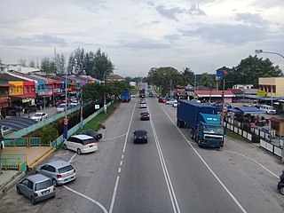
Federal Route 24, or Jalan Muar–Yong Peng, is a federal road in Johor, Malaysia. The roads connects Muar in the west to Yong Peng in the east. It is also a main route to North-South Expressway via Yong Peng Interchange.

Federal Route 54, or Jalan Kuala Selangor–Kepong or Jalan Kepong in Kuala Lumpur side, is a main federal road in Selangor, Malaysia. The road connects Asam Jawa near Kuala Selangor to Kepong near Kuala Lumpur. It is a main route to Kuala Lumpur from Federal Route 5. Federal Route 54 became the backbone of the road system linking Kuala Selangor to Kuala Lumpur before being surpassed by the Kuala Lumpur–Kuala Selangor Expressway E25 in 2011.
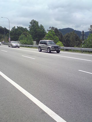
Federal Route 96, or Jalan Simpang Renggam–Benut, is a main federal road in Johor, Malaysia. The road connects the town of Simpang Renggam to Benut in Johor. The road is also a main route to North–South Expressway Southern Route via Simpang Renggam Interchange.
Jalan Seremban-Kuala Pilah or Federal Route 51 is the main federal road in Negeri Sembilan, Malaysia, connecting Seremban to Kuala Pilah. It is a relatively busy road in Negeri Sembilan.

Federal Route 58, or Jalan Batak Rabit-Teluk Intan-Bidor, is a Malaysian federal road in Perak state linking Federal Route 1 at Bidor to Teluk Intan and Federal Route 5.
Federal Route 60 is a federal road in Perak, Malaysia. The road connects Changkat Jering in the north to Kampung Koh in the south. The roads also a main route to North–South Expressway Northern Route via Changkat Jering Interchange.
Federal Route 86, also known as Jalan Jelebu or Jalan Seremban–Simpang Pertang, is a main federal roads in Negeri Sembilan, Malaysia. The roads connects Seremban town in the south to Simpang Pertang, Jelebu in the north. It was the earliest federal roads in Negeri Sembilan, built in 1911 by the Federated Malay States (FMS) government.
San Roque is a settlement in Saipan, in the Northern Mariana Islands. It is located to the north of Tanapag on the island's northwest coast, close to the point where the barrier reef protecting the Tanapag Harbor joins to the island. It is connected to Tanapag by the Marpi Road, which runs the length of the northwestern coast.
Highways in the United States are split into at least four different types of systems: Interstate Highways, U.S. Highways, state highways, and county highways. Highways are generally organized by a route number or letter. These designations are generally displayed along the route by means of a highway shield. Each system has its own unique shield design that will allow quick identification to which system the route belongs.
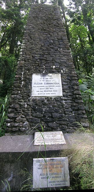
Tregony is a locality in the Southern Downs Region, Queensland, Australia. It is one of the major gateways to the Darling Downs from the Queensland coast.
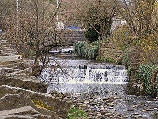
Whitewell Brook is a minor river in Lancashire, England. It is 4.34 miles (6.99 km) long and has a catchment area of 7.67 square miles (19.86 km2).

