
The Jeli District is a district and a parliamentary constituency in western Kelantan, Malaysia. As of 2010, the district's population is estimated to be 42,150. Jeli is administered by the Jeli District Council. Jeli is bordered by the state of Perak to the west, the Thai district of Waeng to the north, Tanah Merah district to the north east and Kuala Krai district to the south east.
Federal Route 4 is a federal road in the north of Peninsula Malaysia. The 307 kilometres (191 mi) road connects Butterworth, Penang to Pasir Puteh in Kelantan. The highway also goes close to the border with Thailand and meets Jalan Kompleks CIQ Bukit Bunga at Bukit Bunga.

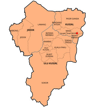
Tanah Merah District is a district (jajahan) in the state of Kelantan in northeast Malaysia. The urban area of Tanah Merah is situated along the Kelantan River. It is bordered by Pasir Mas District in the north, Machang District to the East, Kuala Krai District to the South East, Jeli District to the South West and Thailand in the West.
Federal Route 138 is a federal road in Malacca, Malaysia, connecting Masjid Tanah and Kuala Linggi. It was originally known as Jalan Kuala Sungai Baru-Sungai Udang and Jalan Lubuk Redan-Masjid Tanah. Federal Route FT 138 features Sungai Linggi Bridge and was built to provide a shorter, less-winding alternative to Federal Route 5 for journeys from Malacca City to Port Dickson. Kilometre Zero of Federal Route 138 is at Kampung Jeram near Masjid Tanah.
Federal Route 129 is a federal road in Kelantan, Malaysia. The road connects Pasir Mas in the north to Tanah Merah in the south.
East Coast Economic Region(ECER) is an economic development region based on the east coast of Peninsular Malaysia, which covers the states of Kelantan, Terengganu, and Pahang, and the Johorean districts of Mersing and Segamat. ECER is also one of the three economic corridors launched in Peninsular Malaysia under the leadership of Prime Minister Abdullah Ahmad Badawi, the fifth Prime Minister of Malaysia. The other corridors are Iskandar Malaysia in Johor and the Northern Corridor Economic Region (NCER) that covers the states of Penang, Kedah, Perlis and Northern Perak. The ECER development program spans 12 years, beginning in 2007, and involves Public-Private Participation (PPP).
Federal Route 147, or Jalan Bagan Serai–Alor Pongsu–Selama, is a federal road in Perak, Malaysia. The Kilometre Zero of the Federal Route 147 starts at Bagan Serai.
Federal Route 211, or Jalan Kubang Kerian-Bachok, is a federal road in Kelantan, Malaysia.
Federal Route 196, or Jalan Panglima Bayu-Rantau Panjang-Jeram Pendah, is a federal road in Kelantan, Malaysia. It is an alternative route to Tumpat and Pengkalan Kubor from Rantau Panjang. The Kilometre Zero of the Federal Route 196 starts at Panglima Bayu.
Federal Route 198, or Jalan Jedok-Air Canal-Legeh, is a federal road in Kelantan, Malaysia. The route connects Jedok in the northeast and Kampung Legeh in the southwest.
Federal Route 209, or Jalan Pasir Hor, is a federal road in Kelantan, Malaysia. The road connects Wakaf Che Yeh in the west to Kubang Kerian in the east.
Federal Route 201, or Jalan Nibong-Jakar-Bukit Nangka, is a federal road in Kelantan, Malaysia. The route connects town of Bukit Bunga in the west and Kampung Nibong in the east.
Federal Route 197, or Jalan Tok Deh-Gual Periok, is a federal road in Kelantan, Malaysia.
Federal Route 199, or Jalan Batu Gajah, is a federal road in Kelantan, Malaysia. The route connects Kampung Batu Gajah in the north and Kampung Lawang in the south.
Jalan Pantai Cahaya Bulan, or Jalan Pantai Cinta Berahi, Federal Route 223 is a federal road in Kelantan, Malaysia. The Kilometre Zero of the Federal Route 223 starts at Pantai Cahaya Bulan.
The Tanah Merah Bridge is the main bridge on Kelantan River near Tanah Merah, Kelantan, Malaysia. It is located at Federal Route 4. The 600m bridge was opened on 1 February 1988 and it is located near Guillemard Bridge.
Federal Route 260, or Jalan Pasir Mas-Pohon Tanjung, is a federal road in Kelantan, Malaysia. The road connects Pasir Mas in the east to Pohon Tanjung in the west.
Jalan Sultan Ismail Petra, Federal Route 259, is a federal road in Kelantan, Malaysia. The roads connected Batang Merbau in the west to Tanah Merah in the east. It was named after ninth Sultan of Kelantan, Sultan Ismail Petra, who reigned from 1979 until 2010.
Tanah Merah is a federal constituency in Tanah Merah District, Kelantan, Malaysia, that has been represented in the Dewan Rakyat since 1959.

Pasir Mas District is a district (jajahan) in Kelantan, Malaysia. The district covers an area of 614.15 square kilometers and is bordered by the districts of Tumpat District to the north, Tanah Merah District to the south, Kota Bharu District to the east, and the Thai district of Su-ngai Kolok to the west.

