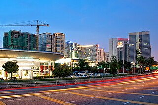
Shah Alam is a city and the state capital of Selangor, Malaysia and situated within the Petaling District and a small portion of the neighbouring Klang District. Shah Alam replaced Kuala Lumpur as the capital city of the state of Selangor in 1978 due to Kuala Lumpur's incorporation into a Federal Territory in 1974. Shah Alam was the first planned city in Malaysia after independence from Britain in 1957.

The Petaling District is a district located in the heart of Selangor in Malaysia. Petaling is not to be confused with the city of Petaling Jaya located in it, nor the mukim of Petaling under Petaling Jaya City. The district office is located in Subang.

Subang Jaya is a city in Petaling District, Selangor, Malaysia. It comprises the southern third district of Petaling. It consists of the neighbourhoods from SS12 to SS19, UEP Subang Jaya (USJ), Putra Heights, Batu Tiga as well as PJS7, PJS9 and PJS11 of Bandar Sunway, the latter of which are partially jurisdictional within Petaling Jaya under the MBPJ. The city is governed by Subang Jaya City Council (MBSJ), which also governs other areas of the Petaling district, such as Puchong and Seri Kembangan. According to Subang Jaya City Council, Subang Jaya has a population of 642,100 in 2015, which makes it the sixth largest city in Malaysia by population.
Federal Highway is a Malaysian controlled-access highway connecting the capital city of Kuala Lumpur, and Klang, Selangor. The highway starts from Seputeh in Kuala Lumpur to Klang, Selangor. It is the busiest highway in Klang Valley during rush hour from/to Kuala Lumpur. The Federal Highway is coded as Federal Route 2.

Kuala Lumpur Middle Ring Road 2, Federal Route 28, is a ring road built by the Malaysian Public Works Department (JKR) to connect neighborhoods near the boundary of Federal Territory of Kuala Lumpur and Selangor. Altogether, the 65.0 km (40.4 mi) of the entire system consists of Federal Route 28, Damansara–Puchong Expressway Damansara–Puchong Expressway and Shah Alam Expressway Shah Alam Expressway. However, the Kuala Lumpur Middle Ring Road 2 is generally referred to as Route 28 since Route 28 occupies about two-thirds of the system.
The Federal Route 2 is a major east–west oriented federal highway in Malaysia. The 276.9 kilometres (172 mi) road connects Port Klang in Selangor to Kuantan Port in Pahang. The Federal Route 2 became the backbone of the road system linking the east and west coasts of Peninsula Malaysia before being surpassed by the East Coast Expressway E8.

Puchong is a major town and a parliamentary constituency in Petaling District, Selangor, Malaysia.

Sunway Pyramid is a shopping mall located in Bandar Sunway, Subang Jaya, Selangor which was developed by Sunway Group.

Bandar Sunway, also known as Sunway City, is an 800-acre integrated township in Subang Jaya, Selangor, Malaysia. This township is named after its developer, Sunway Group, which had also got its name from Sungai Way, a suburb in Selangor.
Persiaran Kerjaya, or Jalan Glemarie, Federal Route 3213, is a major highway in Klang Valley, Selangor, Malaysia. It is a toll-free highway and act as alternative route to Federal Highway.
Jalan Subang–Batu Tiga or Persiaran Jubli Perak, and Jalan Subang, (Federal route FT 3214), is a major highway in Klang Valley region, Selangor, Malaysia.

Bandar Saujana Putra is a township in Kuala Langat District, Selangor, Malaysia.
Batu Tiga–Sungai Buloh Highway, Selangor State Route B9, is the main highway in Klang Valley, Malaysia connects from Batu Tiga Interchange in Batu Tiga to Hospital Sungai Buloh in Sungai Buloh. The highway overlaps with a few roads with the same name but different code: Route 15 and Route 3214. At the Politeknik Junction, it extends towards the eastern side of Shah Alam which is the Persiaran Sukan. The Persiaran Sukan is basically a ring road that covers the eastern side of Shah Alam with some one-way road. The highway was upgraded in 2008.

The Malaysian Expressway System is a network of national controlled-access expressways in Malaysia that forms the primary backbone network of Malaysian national highways. The network begins with the Tanjung Malim–Slim River tolled road which was opened to traffic on 16 March 1966, later North–South Expressway (NSE), and is being substantially developed. Malaysian expressways are built by private companies under the supervision of the government highway authority, Malaysian Highway Authority.
Batu Tiga is a suburb in Subang Jaya, Selangor, Malaysia. It is located at the border between Subang Jaya and Shah Alam. However, it is nearer to Shah Alam than the town centre of Subang Jaya. Subang Hi-Tech Industrial Park in the suburb serve as one of the most major industrial estates in the Klang Valley as it is situated in between Kuala Lumpur, Shah Alam, Klang and Subang.

The Damansara–Shah Alam Elevated Expressway (DASH) E31 is an expressway in Klang Valley, Selangor, Malaysia. Estimated cost of the expressway is MYR 11.5 billion.
Persiaran Mokhtar Dahari, or Shah Alam–Batu Arang Highway or Puncak Alam Highway and Jalan Batu Arang, is a major highway in Selangor, Malaysia.
Taman Putra Perdana is a township in Dengkil sub-district, Sepang District, Selangor, Malaysia. Although the township's postcode is 47100 / 47120 / 47130, which gives it Puchong postal address, it is actually in the Sepang constituency of Selangor, administered by the Sepang Municipal Council (MPSepang). The township was developed by Kenshine Corporation in 1997.
The following is an alphabetical list of articles related to Selangor.

Subang Jaya City Council is the city council which is in charge of the Subang Jaya city and the southern parts of Petaling district. This agency is under Selangor state government of Malaysia. MBSJ are responsible for the public's health and sanitation, waste removal and management, town planning, environmental protection and building control, social and economic development and general maintenance functions of urban infrastructure. The MBSJ headquarters is located in UEP Subang Jaya.


