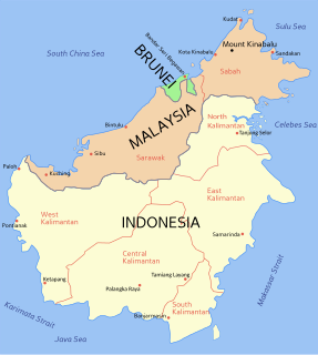
East Malaysia, also known as Sabah, Sarawak and Labuan or Malaysian Borneo, is the part of Malaysia on and near the island of Borneo, the world's third largest island. It consists of the Malaysian states of Sabah and Sarawak, as well as the Federal Territory of Labuan. Labuan is an island in a small archipelago near the coast of Sabah. East Malaysia lies to the east of Peninsular Malaysia, the part of the country on the Malay Peninsula. The two are separated by the South China Sea.

The United States Numbered Highway System is an integrated network of roads and highways numbered within a nationwide grid in the contiguous United States. As the designation and numbering of these highways were coordinated among the states, they are sometimes called Federal Highways, but the roadways were built and have always been maintained by state or local governments since their initial designation in 1926.
A state highway, state road, or state route is usually a road that is either numbered or maintained by a sub-national state or province. A road numbered by a state or province falls below numbered national highways in the hierarchy. Roads maintained by a state or province include both nationally numbered highways and un-numbered state highways. Depending on the state, "state highway" may be used for one meaning and "state road" or "state route" for the other.

Labuan, officially the Federal Territory of Labuan, is a Federal Territory of Malaysia. Its territory includes Labuan Island and six smaller islands, off the coast of the state of Sabah in East Malaysia. Labuan's capital is Victoria and is best known as an offshore financial centre offering international financial and business services via Labuan IBFC since 1990 as well as being an offshore support hub for deepwater oil and gas activities in the region. It is also a tourist destination for people travelling through Sabah, nearby Bruneians and scuba divers. The name Labuan derives from the Malay word labuhan which means harbour.

Highways in Australia are generally high capacity roads managed by state and territory government agencies, though Australia's federal government contributes funding for important links between capital cities and major regional centres. Prior to European settlement, the earliest needs for trade and travel were met by narrow bush tracks, used by tribes of Indigenous Australians. The formal construction of roads began in 1788, after the founding of the colony of New South Wales, and a network of three major roads across the colony emerged by the 1820s. Similar road networks were established in the other colonies of Australia. Road construction programs in the early 19th century were generally underfunded, as they were dependent on government budgets, loans, and tolls; while there was a huge increase in road usage, due to the Australian gold rushes. Local government authorities, often known as Road Boards, were therefore established to be primarily responsible for funding and undertaking road construction and maintenance. The early 1900s saw both the increasingly widespread use of motorised transportation, and the creation of state road authorities in each state, between 1913 and 1926. These authorities managed each state's road network, with the main arterial roads controlled and maintained by the state, and other roads remaining the responsibility of local governments. The federal government became involved in road funding in the 1920s, distributing funding to the states. The depression of the 1930s slowed the funding and development of the major road network until the onset on World War II. Supply roads leading to the north of the country were considered vital, resulting in the construction of Barkly, Stuart, and Eyre Highways.
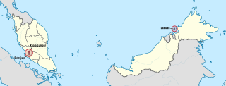
The Federal Territories in Malaysia comprise three territories—Kuala Lumpur, Labuan, and Putrajaya—governed directly by the Federal Government of Malaysia. Kuala Lumpur is the national capital of Malaysia, Putrajaya is the administrative capital, and Labuan is an offshore international financial centre. Kuala Lumpur and Putrajaya are enclaves in the state of Selangor, while Labuan is an island off the coast of Sabah.
A routenumber, designation or abbreviation is an identifying numeric designation assigned by a highway authority to a particular stretch of roadway to distinguish it from other routes and, in many cases, also to indicate its classification, general geographical location and/or orientation. The numbers chosen may be used solely for internal administrative purposes; however, in most cases they are also displayed on roadside signage and indicated on maps.

Malaysian Federal Roads System, is the main national road network in Malaysia. All Federal Roads in Malaysia are under the purview of the Ministry of Works (MOW). According to the Ministerial Functions Act 1969, the MOW is responsible to plan, build and maintain all Federal Roads gazetted under the Federal Roads Act 1959. However, most of the Federal roads' projects were built and maintained by the Malaysian Public Works Department (JKR), which is also one of the implementing agencies under the MOW.
Federal Route 76 is a federal highway in Kedah and Perak state, Malaysia. The 163.7-km federal highway serves as the main route from Perak and Kedah to the East–West Highway FT4, as well as the main route to Thailand via Keroh and Betong.
Second East–West Highway, also known as Simpang Pulai–Kuala Berang Highway, Federal Route 185 and Federal Route 36, is a highway in Peninsular Malaysia which connects Simpang Pulai in Perak to Kuala Jeneris in Terengganu. It overlaps with Federal Route 8 Federal Route 8 between Gua Musang and Sungai Relau. It is notorious for its many sharp corners which increase the risk of road accidents.

Labuan Airport is an airport that serves the federal territory of Labuan in Malaysia. The airport is 2.5 km (1.6 mi) or 5 km (3.1 mi) by road from Victoria. It was planned for Labuan Airport to be a regional hub for connecting flights within the Association of Southeast Asian Nations (ASEAN) but this plan was postponed due to logistics and unsuitability.
Federal Route 15 is main federal road in the Klang Valley region, Selangor, Malaysia. The main link begins from Kampung Melayu Subang at Subang to Sultan Abdul Aziz Shah Airport (Skypark) and ends at Subang Jaya.

Perbadanan Labuan or Labuan Corporation (PL) is a local authority which administrates the Federal Territory of Labuan, Malaysia. This agency is under Ministry of the Federal Territories. PL are responsible for public health and sanitation, waste removal and management, town planning, environmental protection and building control, social and economic development and general maintenance functions of urban infrastructure. The PL main headquarters that is Wisma Perbadanan Labuan located at Jalan Dewan, Bandar Labuan. PL has another office building, Menara Perbadanan Labuan at Jalan OKK Awang Besar.
Federal Route 500 is a 163-kilometre (101 mi) federal highway in Sabah, Malaysia, connecting Kota Kinabalu to Tenom. It serves as the main highway from Kota Kinabalu to towns and villages in the Interior Division of Sabah. Federal Route 500 is one of the five highways in Sabah crossing the Crocker Range; the Tamparuli-Ranau Highway, Kimanis-Keningau Highway and Jalan Tenom-Sipitang are the other three and the new highway, Interior North–South Highway.
Jalan Airport or Labuan Airport Road, Federal Route 739, is a major federal road in Federal Territory of Labuan, Malaysia.
Jalan Kolam, Federal Route 720, is a major federal road in the Federal Territory of Labuan, Malaysia.
Jalan Arsat, Federal Route 731, is a major federal roads in Federal Territory of Labuan, Malaysia.

The Sipitang District is an administrative district in the Malaysian state of Sabah, part of the Interior Division which also includes the districts of Beaufort, Keningau, Kuala Penyu, Nabawan, Tambunan and Tenom. The capital of the district is in Sipitang Town. The ecotourism village of Long Mio and Long Pasia is located in this district, while the small town of Sindumin serves as a gateway to the state of Sarawak.

