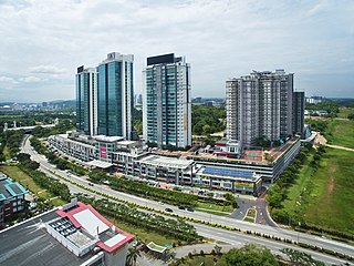
Putrajaya, officially the Federal Territory of Putrajaya, is the administrative centre of Malaysia. The seat of the federal government of Malaysia was moved in 1999 from Kuala Lumpur to Putrajaya because of overcrowding and congestion, whilst the seat of the judiciary of Malaysia was later moved to Putrajaya in 2003. Kuala Lumpur remains as Malaysia's national capital city per the constitution and is still the seat of the head of state and the national legislature, as well as being the country's commercial and financial centre.

Cyberjaya is a city with a science park as its core that forms a key part of the Kuala Lumpur in Malaysia. It is located in Sepang District, Selangor. Cyberjaya is adjacent to and developed along with Putrajaya, Malaysia's government seat. This city aspires to be known as the Silicon Valley of Malaysia.
The North–South Expressway Central LinkNorth–South Expressway Central Link also known as ELITE, is a 63-kilometre (39-mile) controlled-access highway in Malaysia, running between Shah Alam in Selangor and Nilai in Negeri Sembilan. The expressway joins the separated northern and southern sections of the North–South Expressway, allowing interstate traffic to bypass Kuala Lumpur. The expressway also serves as a primary access route to Putrajaya and Kuala Lumpur International Airport.

Malaysian Federal Roads System, is the main national road network in Malaysia. All Federal Roads in Malaysia are under the purview of the Ministry of Works (MOW). According to the Ministerial Functions Act 1969, the MOW is responsible to plan, build and maintain all Federal Roads gazetted under the Federal Roads Act 1959. However, most of the Federal roads' projects were built and maintained by the Malaysian Public Works Department (JKR), which is also one of the implementing agencies under the MOW.

Putrajaya–Cyberjaya Expressway, Federal Route 29, is a major expressway in Klang Valley, Malaysia. The 21.2 km (13.2 mi) expressway connects Serdang interchange on Damansara–Puchong Expressway to Kuala Lumpur International Airport (KLIA) in Sepang. It was named after the two sides of the MSC cities, Putrajaya and Cyberjaya.
The Federal Route 2 is a major east–west oriented federal highway in Malaysia. The 276.9 kilometres (172 mi) road connects Port Klang in Selangor to Kuantan Port in Pahang. The Federal Route 2 became the backbone of the road system linking the east and west coasts of Peninsula Malaysia before being surpassed by the East Coast Expressway E8.

Jalan Seremban-Kuala Pilah or Federal Route 51 is the main federal road in Negeri Sembilan, Malaysia, connecting Seremban to Kuala Pilah. It is a relatively busy road in Negeri Sembilan.

Bandar Sri Damansara is a residential township in Petaling District, Selangor, Malaysia. The township is divided into two sections, SD1-SD5 in the north and SD7-SD15 in the south which are separated by Kuala Selangor-Kepong Highway. It is adjacent to Kepong and Sungai Buloh. The township consists of mixed development of commercial and residential properties. It was previously developed by Land and General Berhad and currently by TA Global.
Persiaran Raja Muda Musa, Federal Route 2, 2A and 2B is a major highway in Klang, Selangor, Malaysia. It connects Klang to Port Klang. It is also a main route to Port Klang. The highway was named after Raja Muda Musa, father of Sultan Sir Alaeddin Sulaiman Shah of Selangor.
Persiaran Persekutuan is a major highway in Putrajaya, Malaysia. It connects Wetland Interchange of the South Klang Valley Expressway in the north to Persiaran Sultan Salahuddin Abdul Aziz Shah in the south.
Persiaran Timur is a major highway in Putrajaya, Malaysia. It connect Persiaran Utara interchange in the north to Seri Setia interchange in the south.

Federal Route 15 is main federal road in the Klang Valley region, Selangor, Malaysia. The main link begins from Kampung Melayu Subang at Subang to Sultan Abdul Aziz Shah Airport (Skypark) and ends at Subang Jaya.
Persiaran Tujuan is a main road in Subang Jaya, Selangor, Malaysia. The road connects Subang Jaya west interchange at Federal Highway to Persiaran Kewajipan. It is one of the busiest roads in UEP Subang Jaya during rush hour from/to Kuala Lumpur. It is an alternative route to Persiaran Kewajipan for motorists to avoid traffic congestion.
The Kemuning–Shah Alam HighwayKemuning–Shah Alam Highway, (LKSA), is an expressway in Klang Valley, Selangor, Malaysia. The 7.3 km (4.5 mi) expressway connects Kemuning Interchange of the Shah Alam Expressway E5 near Kota Kemuning until Federal Highway Route 2 Interchange of the Federal Highway Route 2 near Klang. It originally was given route code South Kedah Expressway but later changed to Kemuning–Shah Alam Highway and South Kedah Expressway was used by South Kedah Expressway.

Batu Tiga–Sungai Buloh Highway, Selangor State Route B9, is the main highway in Klang Valley, Malaysia connects from Batu Tiga Interchange in Batu Tiga to Hospital Sungai Buloh in Sungai Buloh. The highway overlaps with a few roads with the same name but different code: Route 15 and Route 3214. At the Politeknik Junction, it extends towards the eastern side of Shah Alam which is the Persiaran Sukan. The Persiaran Sukan is basically a ring road that covers the eastern side of Shah Alam with some one-way road. The highway was upgraded in 2008.

The MRT Putrajaya Line, is the second Mass Rapid Transit (MRT) line in Klang Valley, Malaysia, and the third fully automated and driverless rail system in the country. It was previously known as the MRT Sungai Buloh–Serdang–Putrajaya Line. The line stretches from Kwasa Damansara to Putrajaya and runs through densely populated areas such as Sri Damansara, Kepong, Batu, Jalan Ipoh, Sentul, Kampung Baru, Jalan Tun Razak, KLCC, Tun Razak Exchange, Kuchai Lama, Seri Kembangan and Cyberjaya.
The Iskandar Coastal Highway (ICH) (formerly Johor Bahru West Coast Parkway) (Malay: Lebuhraya Pesisir Pantai Iskandar (LPPI)) or the stretch of road that includes Lebuhraya Sultan Iskandar, Persiaran Sultan Abu Bakar (formerly Jalan Skudai, Jalan Abu Bakar) and Persiaran Sultan Ismail (formerly Jalan Ibrahim and Persiaran Tun Sri Lanang) (Federal Route 52 (Iskandar Puteri–Danga Bay) and Johor State Route 1 (Danga Bay–City Centre)) is a highway in Johor Bahru District, Johor, Malaysia. The 23 km (14 mi) highway connects Iskandar Puteri in the west to Johor Bahru in the east. It is a toll free highway and part of the Iskandar Malaysia project. The Iskandar Coastal Highway is the fifth east–west-oriented expressway in the Iskandar Malaysia area after the Pasir Gudang Highway, the Pontian–Johor Bahru Link of the Second Link Expressway, the Senai–Desaru Expressway and the Johor Bahru East Coast Highway.
The Automated Enforcement System (AES) is the road safety enforcement system to monitor all federal roads, highways and expressways in Malaysia. This system came into operation on 22 September 2012.
Persiaran Senawang 1, designated as Malaysia Federal Route 242, is a dual-carriageway federal road in Seremban, Negeri Sembilan, Malaysia. Linking Paroi and Senawang, this dual-carriageway serves as the bypass of the Seremban city centre to Kuala Pilah and vice versa. This dual-carriageway may also provide a direct link between the North–South Expressway Southern Route and the Kajang–Seremban Highway. The Kilometre Zero of the Federal Route 242 is at Paroi.

Persiaran Mokhtar Dahari, or Shah Alam–Batu Arang Highway or Puncak Alam Highway and Jalan Batu Arang, is a major highway in Selangor, Malaysia.


