
Transportation in Malaysia started to develop during British colonial rule, and the country's transport network is now diverse and developed. Malaysia's road network is extensive, covering 290,099.38 kilometres, including 2,016.05 km of expressways. The main highway of the country extends over 800 km, reaching the Thai border from Singapore. Peninsular Malaysia has an extensive road network, whilst the road system in East Malaysia is not as well-developed. The main modes of transport in Peninsular Malaysia include buses, trains, cars and to an extent, commercial travel on airplanes.

Sabah is a state of Malaysia located on the northern portion of Borneo, in the region of East Malaysia. Sabah has land borders with the Malaysian state of Sarawak to the southwest and Indonesia's North Kalimantan province to the south. The Federal Territory of Labuan is an island just off Sabah's west coast. Sabah shares maritime borders with Vietnam to the west and the Philippines to the north and east. Kota Kinabalu is the state capital and the economic centre of the state, and the seat of the Sabah State government. Other major towns in Sabah include Sandakan and Tawau. The 2020 census recorded a population of 3,418,785 in the state. It has an equatorial climate with tropical rainforests, abundant with animal and plant species. The state has long mountain ranges on the west side which forms part of the Crocker Range National Park. Kinabatangan River, the second longest river in Malaysia runs through Sabah. The highest point of Sabah, Mount Kinabalu is also the highest point of Malaysia.

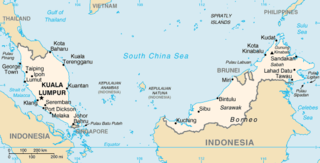
East Malaysia, or the Borneo States, also known as Malaysian Borneo, is the part of Malaysia on and near the island of Borneo, the world's third-largest island. East Malaysia comprises the states of Sabah, Sarawak, and the Federal Territory of Labuan. The small independent nation of Brunei comprises two enclaves in Sarawak. To the south and southeast is the Indonesian portion of Borneo, Kalimantan. East Malaysia lies to the east of Peninsular Malaysia, the part of the country on the Malay Peninsula. The two are separated by the South China Sea.
The geography of Malaysia includes both the physical and the human geography of Malaysia, a Southeast Asian country made up of two major landmasses separated by water—Peninsular Malaysia to the West and East Malaysia to the East—and numerous smaller islands that surround those landmasses. Peninsular Malaysia is on the southernmost part of the Malay Peninsula, south of Thailand, north of Singapore and east of the Indonesian island of Sumatra; East Malaysia comprises most of the northern part of Borneo island, and shares land borders with Brunei to the north and Indonesian Borneo to the south.

Kota Kinabalu, colloquially referred to as KK, is the state capital of Sabah, Malaysia. It is also the capital of the Kota Kinabalu District as well as the West Coast Division of Sabah. The city is located on the northwest coast of Borneo facing the South China Sea. The Tunku Abdul Rahman National Park lies to its west and Mount Kinabalu, which gave the city its name, is located to its east. Kota Kinabalu has a population of 452,058 according to the 2010 census; when the adjacent Penampang and Tuaran districts are included, the metro area has a combined population of 628,725. The 2020 Census revealed an increase in the municipal population to 500,421, while the wider area including the Penampang and Putatan districts had a population of 731,406.

Kudat is the capital of the Kudat District in the Kudat Division of Sabah, Malaysia. Its population was estimated to be around 29,025 in 2010. It is located on the Kudat Peninsula, about 190 kilometres (120 mi) north of Kota Kinabalu, the state capital, and is near the northernmost point of Borneo. It is the largest town in the heartland of the Rungus people which is a sub-ethnic group of the majority Kadazan-Dusun race and is therefore a major centre of Rungus culture. It is also notable for being one of the first parts of Sabah to be settled by Chinese Malaysians, particularly from the Hakka dialect group. It is the Northernmost Malaysian city.

Lawas is a small town and the capital of Lawas District, Limbang Division, Sarawak, Malaysia. This district area is 3,811.90 square kilometres, and population was 46,200. It is 1,200 km from the state capital, Kuching and 200 km from the capital city of Sabah, Kota Kinabalu.

Malaysian Federal Roads System, is the main national road network in Malaysia. All Federal Roads in Malaysia are under the purview of the Ministry of Works (MOW). According to the Ministerial Functions Act 1969, the MOW is responsible to plan, build and maintain all Federal Roads gazetted under the Federal Roads Act 1959. However, most of the Federal roads' projects were built and maintained by the Malaysian Public Works Department (JKR), which is also one of the implementing agencies under the MOW.

Sabah State Railway is a railway system and operator in the state of Sabah in Malaysia. It is the only rail transport system operating on the island of Borneo. The railway consists of a single 134-kilometre line from Tanjung Aru, Kota Kinabalu in West Coast Division to the town of Tenom, in the Interior Division. It was formerly known as North Borneo Railway.

Pan Borneo Highway, also known as Trans-Borneo Highway or Trans-Kalimantan Highway, is a road network on Borneo Island connecting two Malaysian states, Sabah and Sarawak, with Brunei and Kalimantan region in Indonesia. The highway is numbered AH150 in the Asian Highway Network and as Federal Route 1 in Sarawak. In Sabah, the route numbers given are 1, 13 and 22. The highway is a joint project between both governments which started as soon as the formation of Malaysia in 1963 which comprised Malaya, Sabah, Sarawak and Singapore. The lack of a road network system in Sarawak was the main factor of the construction.

Menggatal or Manggatal is a Malaysian town and suburb of Kota Kinabalu District on the west coast of Sabah. It is an outskirt of the state capital, Kota Kinabalu, and is under the jurisdiction of Kota Kinabalu City Hall. It is located along Jalan Tuaran, which is the main road leading north from Kota Kinabalu city centre.

Weston is a small town located on the west coast of the Malaysian state of Sabah, about 100 kilometers south of Kota Kinabalu, the state capital. Weston is part of the Beaufort District in the Interior Division and was named after Arthur J. West, a railway engineer for the North Borneo Chartered Company. Weston is one of the towns along the Pan Borneo Highway.

Muhammad Fuad Stephens, was a Malaysian politician who served as the 1st and 5th Chief Minister of Sabah from September 1963 to December 1964 and again briefly from April 1976 to his death in June 1976, 3rd Yang di-Pertua Negara of Sabah from September 1973 to July 1975, 6th High Commissioner of Malaysia to Australia from 1968 to 1973. In addition, he also served as the 1st Huguan Siou or Paramount Leader of the Kadazandusun community. He played a role in bringing Sabah into the Federation of Malaysia in 1963. While he was initially against the idea of Sabah joining in the Federation, given British concerns about the stability of the region and their move to relinquish all their colonies in the post WWII era, he was gradually convinced to work towards it. He held the chief minister's post from 16 September 1963 until 31 December 1964 when he was forced to resign; and again in 1976 for 54 days from 15 April.
Federal Route 22, Asian Highway Route AH150, is a 310-kilometre (193 mi) federal highway in Sabah, Malaysia, which is also a component of the larger Pan Borneo Highway network. It starts from Tamparuli and ends at Sandakan. The section running from Tamparuli to Ranau, which is known as Tamparuli-Ranau Highway, crosses the Crocker Range just to the south of Mount Kinabalu.

MASwings Sdn Bhd is a regional airline operating the Rural Air Services (RAS) in Borneo Malaysia. MASwings is the successors of FlyAsianXpress which operated RAS flights from 2006-2007, itself the successor Malaysia Airlines operation of RAS flights during 1965-2006. Borneo Airways originally operated RAS flights from 1953-1965 within colonial British Borneo.

Brunei and Malaysia established diplomatic relations in 1984. Brunei has a high commission in Putrajaya, as well as consulate-generals in Kota Kinabalu and Kuching. Malaysia maintains a high commission in Bandar Seri Begawan. Both countries are full members of ASEAN and the Commonwealth of Nations. The two countries share a land border on the island of Borneo. Both countries are majority ethnic Malays and maintain excellent and close economic, cultural, political and defence ties to each other.
The Sarawak section of the Federal Route 1, Asian Highway Route AH 150, also known as Pan Borneo Highway Sarawak or Sarawak First Trunk Road, is a 1077-km federal highway in Sarawak, Malaysia, making the highway as the longest component of the Malaysian portion of the larger Pan Borneo Highway network. Construction of the highway began in 1965 after Sarawak became a member of the federation of Malaysia in 1963.

The Queen Elizabeth Hospital in Kota Kinabalu, Sabah is the main hospital for the city and the whole of Sabah as well as the alternate feeder general hospital for the neighbouring Federal Territory of Labuan, but also accommodates patients from the neighbouring state of Sarawak as well as far as the neighbouring countries/regions of Brunei and also North Kalimantan, Indonesia, the other being the Sarawak General Hospital in Kuching, Sarawak.

The Sipitang District is an administrative district in the Malaysian state of Sabah, part of the Interior Division which also includes the districts of Beaufort, Keningau, Kuala Penyu, Nabawan, Tambunan and Tenom. The capital of the district is in Sipitang Town. The ecotourism village of Long Mio and Long Pasia is located in this district, while the small town of Sindumin serves as a gateway to the state of Sarawak.


