Atakora is the northwesternmost department of Benin. Externally it borders Togo to the west and Burkina Faso to the north; internally it borders the departments of Alibori, Borgou and Donga. Major towns in the Atakora include Natitingou and Tanguiéta, and the major tourist areas include the Tata Somba houses, Pendjari National Park, and various waterfalls. The department of Atakora was bifurcated in 1999, with its southern territory removed to form the newly created Donga Department. The capital of Atakora Department is Natitingou; it is after the Atakora Mountains,
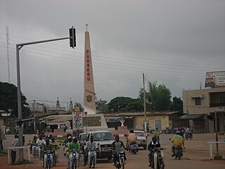
Parakou is the largest city in northern Benin, with an estimated population of around 206,667 people, and capital of the Borgou Department. Administratively the commune of Parakou makes up one of Benin's 77 communes. Since 2015, its mayor is Souradjou Adamou Karimou.

Malanville is a city, arrondissement and commune in the Alibori Department of northeastern Benin, located across the River Niger from Niger. It is known as a centre of cross-border trade and has a major market. Malanville is also a centre for rice-growing. The commune covers an area of 3016 square kilometres and as of 2013 had a population of 168,006 people.
Boukoumbé or Boukombé is a town, arrondissement and commune in north western Benin on the border with Togo. It is known for its market, its whipping ceremony and for its tradition of pipe making. Mount Kousso-Kovangou, the highest point in Benin, lies nearby.
Athiémè is a town and arrondissement located in the Mono Department of Benin. The commune covers an area of 220 square kilometres and as of 2013 had a population of 56,483 people.
Nikki is a town, arrondissement, and commune located in the Borgou Department of Benin. The commune covers an area of 3171 square kilometres and as of 2002 had a population of 99,251 people.
Péhunco or Péhonko is a town, arrondissement and commune located in the Atakora Department of Benin. The commune covers an area of 1,900 kilometres (1,200 mi) and as of 2013 had a population of 78,217 people.
Karimama is a town, arrondissement and commune in the Alibori Department of northeastern Benin. The commune covers an area of 6102 square kilometers and as of 2013 had a population of 66,675 people. The town lies on the border with Niger.
Cobly or Kobli is a town, arrondissement and commune in the Atakora Department of north-western Benin.
Matéri is a town, arrondissement and commune in the Atakora Department of north-western Benin. The commune covers an area of 4740 square kilometres and as of 2013 had a population of 113,958 people.
Kalalè is a town, arrondissement, and commune in the Borgou Department of eastern Benin. The commune covers an area of 3,586 square kilometres (1,385 sq mi) and as of 2013 had a population of 168,882 people.
Lalo is a town, arrondissement, and commune in the Kouffo Department of south-western Benin. The commune covers an area of 432 square kilometres and as of 2013 had a population of 119,926 people.
Sèmè-Kpodji is a town, arrondissement, and commune in the Ouémé Department of south-eastern Benin. The commune covers an area of 250 square kilometres and as of 2013 had a population of 222,701 people.
Adja-Ouèrè is a town, arrondissement, and commune in the Plateau Department of south-eastern Benin. The commune covers an area of 550 square kilometres and as of 2013 had a population of 115,953 people.
Agbangnizoun is a town, arrondissement, and commune in the Zou Department of south-western Benin. The town lies 20 kilometres south-east of Abomey. The commune covers an area of 244 square kilometres and as of 2002 had a population of 55,001 people.
Cotiakou is a town and arrondissement in the Atakora Department of northwestern Benin. It is an administrative division under the jurisdiction of the commune of Tanguiéta. According to the population census conducted by the Institut National de la Statistique Benin on February 15, 2002, the arrondissement had a total population of 9,163.
N'Dahonta is a town and arrondissement in the Atakora Department of northwestern Benin. It is an administrative division under the jurisdiction of the commune of Tanguiéta. According to the population census conducted by the Institut National de la Statistique Benin on February 15, 2002, the arrondissement had a total population of 8,735.
Taiakou is a town and arrondissement in the Atakora Department of northwestern Benin. It is an administrative division under the jurisdiction of the commune of Tanguiéta. According to the population census conducted by the Institut National de la Statistique Benin on February 15, 2002, the arrondissement had a total population of 9,716.
Kandi is a town, arrondissement and commune in the Alibori Department of eastern Benin. Originally a market town, Kandi is now primarily a farming centre. It lies on the nation's main north-south highway, 650 km (400 mi) from Cotonou and 523 km (325 mi) north of Porto-Novo. The town is the capital of the department of Alibori. The commune covers an area of 3,421 km2 (1,321 sq mi) and as of 2013 had a population of 177,683 people. The town itself had a population of 27,227 in 2002.
Kika is a town and arrondissement in the Borgou Department of Benin. It is an administrative division under the jurisdiction of the commune of Tchaourou. According to the population census conducted by the Institut National de la Statistique Benin on February 15, 2002, the arrondissement had a total population of 12398.