Ten Mile Run, New Jersey | |
---|---|
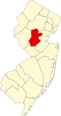
Location in Somerset County Location in New Jersey | |
Coordinates: 40°25′27″N74°35′11″W / 40.424136°N 74.586348°W [1] [2] | |
Country | United States |
State | New Jersey |
County | Somerset |
Township | Franklin |
Area | |
• Total | 2.54 sq mi (6.58 km2) |
• Land | 2.54 sq mi (6.58 km2) |
• Water | 0.00 sq mi (0.00 km2) 0.04% |
Elevation | 213 ft (65 m) |
Population | |
• Total | 2,055 |
• Density | 809.37/sq mi (312.50/km2) |
Time zone | UTC−05:00 (Eastern (EST)) |
• Summer (DST) | UTC−04:00 (Eastern (EDT)) |
Area code(s) | 609/640 and 732/848 |
FIPS code | 34-72435 [1] [2] [6] |
GNIS feature ID | 02584033 [1] [2] |
Ten Mile Run is an unincorporated community and census-designated place (CDP) located in Franklin Township, in Somerset County, in the U.S. state of New Jersey. [2] [7] [8] [9] As of the 2010 United States Census, the CDP's population was 1,959. [10]
According to the United States Census Bureau, Ten Mile Run had a total area of 2.539 square miles (6.576 km2), including 2.538 square miles (6.573 km2) of land and 0.001 square miles (0.002 km2) of water (0.04%). [1] [2]
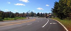
The area is named for the Ten Mile Run, a stream of the same name the hill on which it sits (part of the Rocky Hill Ridge). [11] The area is located along Route 27 (Lincoln Highway) near its intersection with County Route 518. It is located across Route 27 from South Brunswick, Middlesex County. Most of the area consists of less densely-spaced single family homes throughout and commercial establishments along Route 27. The remainder of the area is forested and hilly as the terrain descends towards the Delaware and Raritan Canal and Millstone River. Kendall Park, the CDP located on the South Brunswick side of Route 27, consists of more densely-spaced homes. [12]
Census | Pop. | Note | %± |
---|---|---|---|
2010 | 1,959 | — | |
2020 | 2,055 | 4.9% | |
Population sources: 2010 [10] [5] |
The 2010 United States census counted 1,959 people, 602 households, and 514 families in the CDP. The population density was 771.9 per square mile (298.0/km2). There were 622 housing units at an average density of 245.1 per square mile (94.6/km2). The racial makeup was 31.85% (624) White, 11.94% (234) Black or African American, 0.05% (1) Native American, 50.54% (990) Asian, 0.00% (0) Pacific Islander, 2.30% (45) from other races, and 3.32% (65) from two or more races. Hispanic or Latino of any race were 6.33% (124) of the population. [10]
Of the 602 households, 49.8% had children under the age of 18; 79.6% were married couples living together; 3.8% had a female householder with no husband present and 14.6% were non-families. Of all households, 10.1% were made up of individuals and 3.2% had someone living alone who was 65 years of age or older. The average household size was 3.25 and the average family size was 3.53. [10]
29.4% of the population were under the age of 18, 3.5% from 18 to 24, 33.9% from 25 to 44, 24.9% from 45 to 64, and 8.3% who were 65 years of age or older. The median age was 37.0 years. For every 100 females, the population had 105.3 males. For every 100 females ages 18 and older there were 103.2 males. [10]
Cherry Hill Mall is a unincorporated community and growing census-designated place (CDP) located in Cherry Hill, in Camden County, in the U.S. state of New Jersey. As of the 2020 United States census, the CDP’s population was 14,805, its highest decennial count ever and an increase of 634 (+4.5%) from the 14,171 residents recorded at the 2010 census count, which in turn reflected an increase of 933 (+7.0%) from the 13,238 counted in the 2000 census. The CDP is home to the namesake Cherry Hill Mall shopping complex.
White Horse is an unincorporated community and census-designated place (CDP) located within Hamilton Township, in Mercer County, in the U.S. state of New Jersey. As of the 2010 United States Census, the CDP's population was 9,494.
Kendall Park is an unincorporated community and census-designated place (CDP) located within South Brunswick Township, in Middlesex County, in the U.S. state of New Jersey. As of the 2010 United States Census, the CDP's population was 9,339. Kendall Park has a post office with its own ZIP Code (08824) that encompasses the entire CDP, as well as some surrounding areas.
Madison Park is an unincorporated community and census-designated place (CDP) located within Old Bridge Township, in Middlesex County, in the U.S. state of New Jersey. As of the 2010 United States Census, the CDP's population was 7,144. The name "Madison Park" reflects Old Bridge's original name of "Madison Township" which it had when it was formed on March 2, 1869 from portions of South Amboy Township, until November 5, 1975, when voters approved a referendum changing the township's name to Old Bridge Township.
Fairview is an unincorporated community and census-designated place (CDP) located within Middletown Township, in Monmouth County, in the U.S. state of New Jersey. As of the 2010 United States Census, the CDP's population was 3,806.
Lincroft is an unincorporated community and census-designated place (CDP) within Middletown Township, in Monmouth County, in the U.S. state of New Jersey. As of the 2020 United States census, the CDP had a population of 7,060, teflecting a 15.1% increase from the 6,135 residents enumerated at the 2010 U.S. Census, in turn a decline of 120 residents (-1.9%) from the 6,255 counted in the 2000 U.S. Census.
Strathmore is an unincorporated community and census-designated place (CDP) within Aberdeen Township, in Monmouth County, in the U.S. state of New Jersey. At the 2010 census, the CDP's population was 7,258.
Cedar Glen West is an unincorporated community and census-designated place (CDP) located within Manchester Township, in Ocean County, in the U.S. state of New Jersey. As of the 2010 United States Census, the CDP's population was 1,267.
Leisure Knoll is an unincorporated community and census-designated place (CDP) located within Manchester Township, in Ocean County, in the U.S. state of New Jersey. As of the 2010 United States Census, the CDP's population was 2,490.
Waretown is an unincorporated community and census-designated place (CDP) located within Ocean Township, in Ocean County, in the U.S. state of New Jersey. As of the 2010 United States Census, the CDP's population was 1,569. Waretown is home to Albert Music Hall.
Six Mile Run is an unincorporated community and census-designated place (CDP) located in Franklin Township, in Somerset County, in the U.S. state of New Jersey. As of the 2010 United States Census, the CDP's population was 3,184.
Columbia is an unincorporated community and census-designated place (CDP) located within Knowlton Township in Warren County, in the U.S. state of New Jersey. While the community has existed for over a century, the CDP was created as part of the 2010 United States Census. As of the 2010 Census, the CDP's population was 229. The area is served as United States Postal Service ZIP Code 07832.
Buttzville is an unincorporated community and census-designated place (CDP) located within White Township in Warren County, in the U.S. state of New Jersey, that was created as part of the 2010 United States Census. As of the 2010 Census, the CDP's population was 146.
Robbinsville is a census-designated place (CDP) located within Robbinsville Township in Mercer County, in the U.S. state of New Jersey. The area is served as United States Postal Service ZIP Code 08691. As of the 2010 United States Census, the population for the CDP was 3,041.
Franklin Park is an unincorporated community and census-designated place (CDP) located within Franklin Township, in Somerset County, in the U.S. state of New Jersey. As of the 2010 United States Census, the CDP's population was 13,295. Route 27 bisects the village and serves as the dividing line between the two counties. The adjacent sections of South Brunswick and North Brunswick, Middlesex County on the east side of Route 27 are also known as Franklin Park, but are not included within the CDP's boundaries.
Stewartsville is an unincorporated community and census-designated place (CDP) located within Greenwich Township in Warren County, in the U.S. state of New Jersey, that was created as part of the 2010 United States Census. As of the 2010 Census, the CDP's population was 349.
Robertsville is a census-designated place and unincorporated community located within Marlboro Township, in Monmouth County, in the U.S. state of New Jersey. At the 2010 census, the CDP's population was 11,297.
Florence is an unincorporated community and census-designated place (CDP) located within Florence Township, in Burlington County, in the U.S. state of New Jersey, that was established as part of the 2010 United States Census. As of the 2000 United States Census, the CDP was combined as Florence-Roebling, which had a total population of 8,200. As of the 2010 Census, the Florence-Roebling CDP was split into its components, Roebling and Florence. As of the 2010 Census, the population of the Florence CDP was 4,426.
Blairstown is an unincorporated community and census-designated place (CDP) located within Blairstown Township, in Warren County, in the U.S. state of New Jersey. The CDP was created as part of the 2010 United States census. As of the 2010 United States census, the CDP's population was 515.
Mount Hermon is an unincorporated community and census-designated place (CDP) located within Hope Township in Warren County, in the U.S. state of New Jersey, that was defined as part of the 2010 United States Census. As of the 2010 Census, the CDP's population was 141.