The Cut, London

Last updated

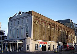
The Old Vic theatre, at the western end of the Cut in Lambeth Waterloo the old vic 1.jpg
The Old Vic theatre, at the western end of the Cut in Lambeth
The Young Vic theatre, halfway along the northern side of the Cut Young Vic.jpg
The Young Vic theatre, halfway along the northern side of the Cut

The Cut (formerly New Cut) is a street in London which runs between Waterloo Road in Lambeth and Blackfriars Road in Southwark, approximately parallel to the South Eastern Railway. The Old Vic theatre is at the western (Lambeth) end, and the more experimental Young Vic theatre halfway along on the other side. Lewisham Southwark College is sited on the south side of the Cut and at the eastern (Southwark) end is Southwark Underground station. Waterloo and Waterloo East stations are also nearby.

Street market

Lower Marsh and the Cut formed the commercial heart of the area from the early 19th century. Henry Mayhew estimated in the 1840s that 300 costermongers attended the market here. He described the scene in his work London Labour and the London Poor :

THE LONDON STREET MARKETS ON A SATURDAY NIGHT.

The street sellers are to be seen in the greatest numbers at the London street markets on a Saturday night. Here, and in the shops immediately adjoining, the working-classes generally purchase their Sunday's dinner ... on Saturday night, or early on Sunday morning, the New-cut, and the Brill in particular, is almost impassable.

Indeed, the scene in these parts has more of the character of a fair than a market. There are hundreds of stalls, and every stall has its one or two lights ... these, with the sparkling ground-glass globes of the tea-dealers' shops, and the butchers' gaslights streaming and fluttering in the wind, like flags of flame, pour forth such a flood of light, that at a distance the atmosphere immediately above the spot is as lurid as if the street were on fire. ...

This stall is green and white with bunches of turnips—that red with apples, the next yellow with onions, and another purple with pickling cabbages. One minute you pass a man with an umbrella turned inside up and full of prints; next, you hear one with a peepshow of Mazeppa, and Paul Jones the pirate, describing the pictures to the boys looking in at the little round windows. Then is heard the sharp snap of the percussion-cap from the crowd of lads firing at the target for nuts; and the moment afterwards, you see either a black man half-clad in white, and shivering in the cold with tracts in his hand, or else you hear the sounds of music from Frazier's Circus ... Such, indeed, is the riot, the struggle, and the scramble for a living, that the confusion and uproar of the New-cut on Saturday night have a bewildering and saddening effect upon the thoughtful mind.

The fortunes of the street market changed rapidly with time. In 1851 Mayhew wrote: "Since the above description was written, the New Cut has lost much of its noisy and brilliant glory. In consequence of a New Police regulation, "stands" or "pitches" have been forbidden, and each coster, on a market night, is now obliged, under pain of the lock-up house, to carry his tray, or keep moving with his barrow. The gay stalls have been replaced by deal boards, some sodden With wet fish, others stained purple with blackberries, or brown with walnut-peel; and the bright lamps are almost totally superseded by the dim, guttering candle. Even the pole under the tray or "shallow" is resting on the ground, the policeman on duty is obliged to interfere. The mob of purchasers has diminished one-half; and instead of the road being filled with customers and trucks, the pavement and kerb-stones are scarcely crowded." [1]

The market in the Cut continued until the 1950s, when the street was designated as the B300 thoroughfare between Borough High Street and Westminster Bridge Road; the remaining traders moved to Lower Marsh where some street stalls continue (to 2019), or to new shops rebuilt on the bombed sites.

A boxing gymnasium situated above a pub on the Cut is alleged to be where the modern rules for the sport of boxing were penned. The street is also now home to a range of restaurants, shops and offices.

Related Research Articles

<span class="mw-page-title-main">Newington, London</span> Human settlement in England

Newington is a district of South London, just south of the River Thames, and part of the London Borough of Southwark. It was an ancient parish and the site of the early administration of the county of Surrey. It was the location of the County of London Sessions House from 1917, in a building now occupied by the Inner London Crown Court.

<span class="mw-page-title-main">London Borough of Lambeth</span> Borough in United Kingdom

Lambeth is a London borough in South London, England, which forms part of Inner London. Its name was recorded in 1062 as Lambehitha and in 1255 as Lambeth. The geographical centre of London is at Frazier Street near Lambeth North tube station, though nearby Charing Cross on the other side of the Thames in the City of Westminster is traditionally considered the centre of London.

<span class="mw-page-title-main">South Bank</span> Human settlement in England

The South Bank is an entertainment and commercial district in central London, next to the River Thames opposite the City of Westminster. It forms a narrow strip of riverside land within the London Borough of Lambeth and the London Borough of Southwark,. As such, the South Bank may be regarded as somewhat akin to the riverside part of an area known previously as Lambeth Marsh and North Lambeth.

<span class="mw-page-title-main">Lambeth</span> Human settlement in England

Lambeth is a district in South London, England, in the London Borough of Lambeth. Lambeth was an ancient parish in the county of Surrey. It is situated one mile south of Charing Cross. The population of the London Borough of Lambeth was 303,086 in 2011. The area experienced some slight growth in the medieval period as part of the manor of Lambeth Palace. By the Victorian era the area had seen significant development as London expanded, with dense industrial, commercial and residential buildings located adjacent to one another. The changes brought by World War II altered much of the fabric of Lambeth. Subsequent development in the late 20th and early 21st centuries has seen an increase in the number of high-rise buildings. The area is home to the International Maritime Organization. Lambeth is home to one of the largest Portuguese-speaking communities in the UK, and is the second most commonly spoken language in Lambeth after English.

<span class="mw-page-title-main">East Street Market</span> Market in Walworth, South London

East Street Market also known locally as 'The Lane', or 'East Lane', is a street market in Walworth in South East London.

<span class="mw-page-title-main">Southwark tube station</span> London Underground station

Southwark is a London Underground station in the London Borough of Southwark at the corner of Blackfriars Road and The Cut. It is between Waterloo and London Bridge stations on the Jubilee line, and is in Travelcard Zone 1. It was opened on 20 November 1999 as part of the Jubilee Line Extension. The station is somewhat west of historic Southwark, which is served by Borough and London Bridge stations. Its entrance is across the road from the disused Blackfriars Road railway station.

<span class="mw-page-title-main">Metropolitan Borough of Lambeth</span> Metropolitan borough of England

Lambeth was a civil parish and metropolitan borough in south London, England. It was an ancient parish in the county of Surrey. The parish was included in the area of responsibility of the Metropolitan Board of Works in 1855 and became part of the County of London in 1889. The parish of Lambeth became a metropolitan borough in 1900, following the London Government Act 1899, with the parish vestry replaced by a borough council.

<span class="mw-page-title-main">Brixton Market</span> Street market in south London

Brixton Market comprises a street market in the centre of Brixton, south London, and the adjacent covered market areas in nearby arcades Reliance Arcade, Market Row and Granville Arcade.

<span class="mw-page-title-main">Camden Market</span> Retail markets in London, England

The Camden markets are a number of adjoining large retail markets, often collectively referred to as Camden Market or Camden Lock, located in the historic former Pickfords stables, in Camden Town, London. It is situated north of the Hampstead Road Lock of the Regent's Canal. Famed for their cosmopolitan image, products sold on the stalls include crafts, clothing, bric-a-brac, and fast food. It is the fourth-most popular visitor attraction in London, attracting approximately 250,000 people each week.

<span class="mw-page-title-main">Inverness Street Market</span>

Inverness Street Market is an outdoor street market in Camden, North London. Licences to trade are issued by Camden London Borough Council.

<span class="mw-page-title-main">Westminster Bridge Road</span>

Westminster Bridge Road is a road in London, England. It runs on an east–west axis and passes through the boroughs of Lambeth and Southwark.

<span class="mw-page-title-main">Waterloo Road, London</span> Main road in the Waterloo

Waterloo Road is the main road in the Waterloo district of London, England straddling the boroughs of Lambeth and Southwark. It runs between Westminster Bridge Road close to St George's Circus at the south-east end and Waterloo Bridge across the River Thames towards London's West End district at the north-west end.

<span class="mw-page-title-main">Baylis Road</span>

Baylis Road is a thoroughfare in Lambeth, London SE1, England running between Westminster Bridge Road to the South-West and Waterloo Road to the North-East.

<span class="mw-page-title-main">Lower Marsh</span> Street in Waterloo, London

Lower Marsh is a street in the Waterloo neighbourhood of London, England. It is adjacent to Waterloo railway station in the London Borough of Lambeth. It is the location of Lower Marsh Market.

Waterloo is a district in Central London, and part of the Bishops ward of the London Borough of Lambeth. It is situated 1 mile (1.6 km) east of Charing Cross. The area is part of a business improvement district which includes The Cut and the Old Vic and Young Vic theatres. It includes some sections of the London Borough of Southwark.

<span class="mw-page-title-main">Queen's Market</span>

Queen's Market, also known as Queen's Road Market, and Green Street Market, is a historic street market in the London Borough of Newham. It lies adjacent to Green Street and Upton Park tube station.

<span class="mw-page-title-main">Lambeth Marsh</span>

Lambeth Marsh is one of the oldest settlements on the South Bank of London, England.

<span class="mw-page-title-main">Chalton Street Market</span>

Chalton Street Market is a street market in Camden, North London.

Street trading is selling from a stall, stand, or vehicle in the street rather than in a market hall or square. A collection of regular, and adjacent, street traders forms a street market. Where traders operate on their own, from a regular location, these are variously described as isolated pitches, scattered sites, or miscellaneous sites. Peripatetic traders are termed pedlars.

<span class="mw-page-title-main">Leather Lane Market</span>

Leather Lane Market is an outdoor street market in the Holborn area of the London Borough of Camden. Taking place on Leather Lane, it is the oldest street market in Camden. Licences to trade are issued by Camden London Borough Council.

References

  1. The London Street-Folk. Vol. 1. London, UK: George Woodfall and Son. 1851. Retrieved 30 September 2013. Volume 1 E-Text. hdl:10427/53837 via Tufts Digital Library.

Coordinates: 51°30′12.3″N0°6′24.6″W / 51.503417°N 0.106833°W / 51.503417; -0.106833