The Trumpeter Islets comprise a group of two unpopulated islets, with a combined area of about a hectare, located close to the south-western coast of Tasmania, Australia. Situated some 6 kilometres (3.7 mi) where the mouth of Port Davey meets the Southern Ocean, the 1-hectare (2.5-acre) island is part of the Trumpeter Islets Group, and comprises part of the Southwest National Park and the Tasmanian Wilderness World Heritage Site.

The Needle Rocks, also known as the Needles, are a group of five main rock islets located close to the south-western coast of Tasmania, Australia. With a combined area of approximately 10.5 hectares (0.041 sq mi), the islets are part of the Maatsuyker Islands Group, and comprise part of the Southwest National Park and the Tasmanian Wilderness World Heritage Site.
The Albatross Island, part of the Hunter Island Group, is an 18-hectare (44-acre) island and nature reserve located in Bass Strait, that lies between north-west Tasmania and King Island, Australia. The Peerapper name for the island is Tangatema.

Trefoil Island , officially known as titima / Trefoil Island, is an island with an area of 115.79 ha, in south-eastern Australia. It is part of Tasmania’s Trefoil Island Group, lying close to Cape Grim, Tasmania's most north-westerly point, in Bass Strait. It is owned by the Trefoil Island Aboriginal Cooperative and is home to an estimated 1.5 million breeding pairs of short-tailed shearwaters, which are subject to annual muttonbirding activities. Approval is required to visit.

The Harbour Islets are a group of two adjacent small rocky islands, joined at low tide, part of Tasmania’s Trefoil Island Group, lying close to Cape Grim, Tasmania's most north-westerly point, in Bass Strait, with a combined area of 3.13 ha, in south-eastern Australia.

The Gull Island, part of the Passage Group within the Furneaux Group, is an 8.5-hectare (21-acre) granite island, located in Bass Strait southeast of Cape Barren Island, in Tasmania, in south-eastern Australia. The island is a conservation reserve and with the Passage and Forsyth islands, the Gull Island forms part of the Forsyth, Passage and Gull Islands Important Bird Area (IBA), identified as such by BirdLife International because it supports over 1% of the world populations of little penguins and black-faced cormorants.

The Forsyth Island, part of the Passage Group within the Furneaux Group, is a 167-hectare (410-acre) granite island, located in Bass Strait south of Cape Barren Island, in Tasmania, in south-eastern Australia. With the Passage and Gull islands, the Forsyth Island forms part of the Forsyth, Passage and Gull Islands Important Bird Area (IBA), identified as such by BirdLife International because it supports over 1% of the world populations of little penguins and black-faced cormorants.

The Spike Island, part of the Passage Group within the Furneaux Group, is a close pair of unpopulated granite islands with a combined area of 6 hectares, located in Bass Strait, south of Cape Barren Island in Spike Bay just off the west coast of Clarke Island, in Tasmania, in south-eastern Australia.

The Big Black Reef, part of the Long Island Group within the Furneaux Group, is a 0.54-hectare (1.3-acre) unpopulated small, flat dolerite island, located in Bass Strait, lying west of Cape Barren Island, Tasmania, in south-eastern Australia.
The Anderson Island, also known as Woody Island, part of the Tin Kettle Island Group of the Furneaux Group, is a 166-hectare (410-acre) granite island, located in Bass Strait, lying northeast of Tasmania, in south-eastern Australia. Anderson Island lies between Flinders and Cape Barren Islands and is partly a pastoral lease used for grazing sheep and cattle. The island is joined at low tide to nearby Little Anderson and Tin Kettle Islands by extensive intertidal mudflats. The island is supposed to be named after John Anderson, a sealer living on the island by 1842.
The Doughboy Island, part of the Tin Kettle Group within the Furneaux Group, is a 30-hectare (74-acre) unpopulated mainly granite island, located in Bass Strait, lying west of the Flinders and Cape Barren islands, Tasmania, in south-eastern Australia.

The Babel Island, part of the Babel Group within the Furneaux Group, is a 440-hectare (1,100-acre) granite island, located in Bass Strait, lying off the east coast of Flinders Island, Tasmania, south of Victoria, Australia. The privately owned island was named by Matthew Flinders from the noises made by the seabirds there.
The Ninth Island, officially Tareerpattel-tarerenner / Ninth Island, is a 32-hectare (79-acre) uninhabited granite island situated in Bass Strait as part of the Waterhouse Island Group, lying close to the north-eastern coast of Tasmania, Australia. In November 2018, it was listed for sale for the fourth time, at $1.98 million. The property for sale is a landlocked title within a conservation covenant, preventing access to the island by any means except helicopter.

Swan Island, part of the Waterhouse Island Group, is a 239-hectare (590-acre) granite island situated in Banks Strait, part of Bass Strait, lying close to the north-eastern coast of Tasmania, Australia.
Hen Island is an island located close to the south-western coast of Tasmania, Australia. The 7.6-hectare (0.029 sq mi) island is part of the Maatsuyker Islands Group, and comprises part of the Southwest National Park and the Tasmanian Wilderness World Heritage Site.

The Ile du Golfe is a limestone island located close to the south-western coast of Tasmania, Australia. The long, narrow dolphin-shaped 68-hectare (0.26 sq mi) island is part of the Maatsuyker Islands Group, and comprises part of the Southwest National Park and the Tasmanian Wilderness World Heritage Site.

Louisa Island is an island with a short sandy tombolo, located adjacent to the south-western coast of Tasmania, Australia. The irregularly shaped 23-hectare (0.089 sq mi) island is part of the Maatsuyker Islands Group, and comprises part of the Southwest National Park and the Tasmanian Wilderness World Heritage Site.

Flat Witch Island, also known as Little Witch Island, is an island located close to the south-western coast of Tasmania, Australia. The 64-hectare (0.25 sq mi) island is part of the Maatsuyker Islands Group, and comprises part of the Southwest National Park and the Tasmanian Wilderness World Heritage Site.
Walker Island is an island located close to the south-western coast of Tasmania, Australia. The 15-hectare (0.058 sq mi) island is part of the Maatsuyker Islands Group, and comprise part of the Southwest National Park and the Tasmanian Wilderness World Heritage Site.
West Pyramid is an unpopulated steep-sided island located close to the south-western coast of Tasmania, Australia. Situated some 1 kilometre (0.62 mi) north of the mouth of Port Davey where it meets the Southern Ocean, the 2.5-hectare (6.2-acre) island is part of the Trumpeter Islets Group, and comprises part of the Southwest National Park and the Tasmanian Wilderness World Heritage Site.
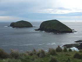
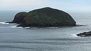 The western of the two islands, furthest from the coast
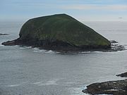 The eastern of the two islands, closest to the coast
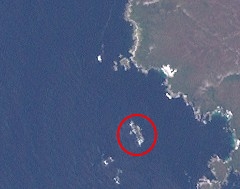
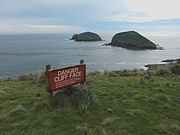 Cliff warning sign at Cape Grim, Tasmania, with The Doughboys in the background