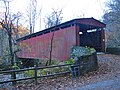
Thomas Mill Covered Bridge | |
 Thomas Mill Covered Bridge in 1972 | |
   | |
| Location | Thomas Mill Rd., Wissahickon Valley Park, Philadelphia, Pennsylvania |
|---|---|
| Coordinates | 40°04′19″N75°13′32″W / 40.07187°N 75.22559°W |
| Built | 1855 |
| MPS | Covered Bridges of the Delaware River Watershed TR |
| NRHP reference No. | 80003621 [1] |
| Added to NRHP | December 1, 1980 |
The Thomas Mill Covered Bridge, aka the Thomas Mill Bridge or the Thomas Mill Road Covered Bridge, is a historic, single-span, wooden covered bridge across the Wissahickon Creek in Wissahickon Valley Park in Northwest Philadelphia, Pennsylvania.
Contents
It is the only remaining covered bridge in Philadelphia and is the only covered bridge in a major US city. It was listed on the National Register of Historic Places in 1980. It is a Contributing Property of the Chestnut Hill Historic District. [1]