
Ernakulam is a district of Kerala, India. Situated in the central part of the state, spanning an area of about 3,000 km2, Ernakulam district is home to over 9% of Kerala’s population. Its headquarters is located at Kakkanad. Ernakulam district includes Kochi city, which is known as the commercial capital of Kerala. The district is famous for its ancient temples, churches, and mosques. The district includes the largest metropolitan region of the state, Greater Cochin. Ernakulam district is the highest revenue yielding district and the district with most number of industries in the state, and hence called the financial, industrial and commercial capital of Kerala. All these factors make Ernakulam district to contribute around 60% of the annual state revenue. It is the third most populous district in Kerala, after Malappuram and Thiruvananthapuram. Ernakulam district also hosts the highest number of international and domestic tourists in Kerala state.

Idukki is a district in the Indian state of Kerala. It was constituted on 26 January 1972, by splitting the district of Kottayam into two parts. Its division was earlier headquartered at Kottayam city, but moved to Painavu in June 1976. Idukki district lies amid the Western Ghats of Kerala. Though it is regarded as the second-largest district in the region, it has the lowest population density among the districts of Kerala, the urban population being higher than the rural. Idukki is rich in forests and also known as the "Spice Garden of Kerala".

The Śabarimala Temple is a temple complex located at Sabarimala inside the Periyar Tiger Reserve in the Perinad Village, Pathanamthitta district, Kerala, India. It is one of the largest annual pilgrimage sites in the world with an estimate of over 40 to 50 million devotees visiting every year. The temple is dedicated to a Hindu celibate deity Ayyappan also known as Dharma Shasta, who according to belief is the son of Shiva and Mohini, the feminine incarnation of Vishnu. The traditions of Sabarimala are a confluence of Shaivism, Shaktism, Vaishnavism, and other Śramaṇa traditions.
Thekkady(Idukki district) is a town near Periyar National Park, an important tourist attraction in the Kerala state of India.

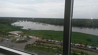
The Kerala backwaters are a network of brackish lagoons and lakes lying parallel to the Arabian Sea coast of Kerala state in southern India, as well as interconnected canals, rivers, and inlets, a labyrinthine system formed by more than 900 kilometres (560 mi) of waterways, and sometimes compared to American bayous. The network includes five large lakes linked by canals, both man made and natural, fed by 38 rivers, and extending virtually half the length of Kerala state. The backwaters were formed by the action of waves and shore currents creating low barrier islands across the mouths of the many rivers flowing down from the Western Ghats range. In the midst of this landscape there are a number of towns and cities, which serve as the starting and end points of backwater cruises.

The Vaigai is a river in the Tamil Nadu state of southern India; it passes through the towns of Theni, Dindigul and Madurai. It originates in Varusanadu Hills, the Periyar Plateau of the Western Ghats range, and flows northeast through the Kambam Valley, which lies between the Palani Hills to the north and the Varushanad Hills to the south. The Vattaparai Falls are located on this river. As it rounds the eastern corner of the Varushanad Hills, the river turns southeast, running through the region of Pandya Nadu. Madurai, the largest city in the Pandya Nadu region and its ancient capital, lies on the Vaigai. The river empties into the Palk Strait near Uchipuli, close to Pamban bridge in Ramanathapuram District.

Aluva is a municipality and a northern suburb of the city of Kochi in Kerala, India. It is a part of the Kochi Metropolitan area and is situated around 15 km (9.3 mi) from the city center on the banks of Periyar River. A major transportation hub, with easy access to all major forms of transportation, Aluva acts as a corridor which links the highland districts to the rest of the state. Cochin International Airport at Nedumbassery is 11.7 km from Aluva. Aluva is accessible through rail, air, metro along with major highways and roadlines.
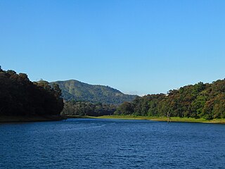
Periyar is the longest river and the river with the largest discharge potential in the Indian state of Kerala. It is one of the few perennial rivers in the region and provides drinking water for several major towns. The Periyar is of utmost significance to the economy of Kerala. It generates a significant proportion of Kerala's electrical power via the Idukki Dam and flows along a region of industrial and commercial activity. The river also provides water for irrigation and domestic use throughout its course besides supporting a rich fishery. Due to these reasons, the river has been named the "Lifeline of Kerala". Kochi city, in the vicinity of the river mouth draws its water supply from Aluva, an upstream site sufficiently free of seawater intrusion. Twenty five percent of Kerala's industries are along the banks of river Periyar. These are mostly crowded within a stretch of 5 kilometres (3 mi) in the Eloor-Edayar region (Udhyogamandal), about 10 kilometres (6 mi) north of Kochi harbor.

The Pamba River is the third longest river in the South Indian state of Kerala after Periyar and Bharathappuzha and the longest river in the erstwhile princely state of Travancore. Sabarimala temple dedicated to Lord Ayyappa is located on the banks of the river Pamba. In old Hindu Epics, Pampa was Lord Brahma's daughter, who was later married to Lord Shiva.
Edathua is a small village in Kuttanad, Alappuzha district, Kerala, India.

Thrissur is a district of Kerala situated in the central part of that state. Spanning an area of about 3,032 km2 (1,171 sq mi), Thrissur district is home to over 9% of Kerala's population.

Theni District is one of the 38 districts of Tamil Nadu state in India. Theni district is Located beside Madurai district. The town of Theni is the district headquarters. The district is divided into two natural divisions: The hilly areas are constituted by parts of the Five taluk's Theni, Bodinayakanur, Periyakulam, Uthamapalayam, Usilampatti and Andipatti with thick vegetation and perennial streams from the hills on the western side and Cumbum valley which lies in Uthamapalayam taluk. As of 2011, Theni district had a population of 1,245,899 with a sex ratio of 980 females for every 1,000 males.
Cheranallur or Cheranellore or Cheranelloor is a suburb of Kochi city in the state of Kerala, India and lies on the banks of the Periyar River. According to tradition, the area was named by its earlier inhabitants who found this place very fertile and beautiful. The name in its local language Malayalam means "Good Village of Cheras".

Cumbum or Kambam, is a town and municipality in Theni district in the western part of the Madurai Region Indian state of Tamil Nadu.

Kodanad is a rural riverside village of Ernakulam district in Kerala, South India. Kodanad is situated on the south bank of Periyar river, about 42 kilometers east of Kochi. The nearest airport is Cochin International Airport which is about 20 km (12 mi) by road. The village is a major tourist destination because it houses an Elephant training center.

Neeleeswaram, a small village in the Ernakulam district of the Kerala state of India. It is on the way to the famous St. Thomas pilgrim centre of Malayattoor.

Marampally is a village in the Ernakulam district in the Indian state of Kerala.

Malayattoor is a village in Aluva Taluk. It is situated around 15 km (9 mi) north-east of Angamaly in Ernakulam District in the state of Kerala in South India. The name `Malayattoor' is an amalgamation of three small words. Mala (Mountain) Arr (River) Oore (Place). This is to say, Malayattoor is a meeting place of mountain, river, and land.

Pizhala is an island near Kochi surrounded by river Periyar. It is the central part and Capital of Kadamakkudy Grama Panchyath, Kanayannur Taluk, Ernakulam District in the Indian state of Kerala. The name Pizhala is derived from the Portuguese words paz na ilha, which mean 'peace on island'. Pizhala island was formed naturally due to the great floods of Periyar in 1341 AD, which choked the Muziris Port, one of the greatest ports in Ancient World.
Kaprikad is a rural riverside village of Ernakulam district, Kerala, southern India. Kaprikad is situated on the south bank of Periyar river, about 42 kilometers east of Kochi. The nearest airport is Cochin International Airport which is about 18 km (12 mi) by road. The village is a major tourist destination because it houses an elephant training center.

