
Indian Lake is a town in Hamilton County, New York, United States. The population was 1,352 at the 2010 census. The name is from a lake of the same name that is largely inside the town. There are no permanent stop lights in the town. Law enforcement is provided by New York State Troopers and Hamilton County Sheriff's Office.

Wells is a town in Hamilton County, New York, United States. The population was 674 at the 2010 census. The town is named after Joshua Wells, a land agent, who built the first mills in the area. It is in the Adirondack Park and on the eastern border of the county. It is northwest of Schenectady.

Ohio is a town in Herkimer County, New York, United States. The population was 1,002 at the 2010 census. The town is named after the state of Ohio. The town is in the northern part of the county and northeast of Utica. Part of Ohio is within the Adirondack Park.
Webb is the northernmost town in Herkimer County, New York, United States. As of the 2010 census it had a population of 1,807.

Blanca Peak is the fourth highest summit of the Rocky Mountains of North America and the U.S. state of Colorado. The ultra-prominent 14,351-foot (4,374 m) peak is the highest summit of the Sierra Blanca Massif, the Sangre de Cristo Range, and the Sangre de Cristo Mountains. The fourteener is located 9.6 miles (15.5 km) north by east of the Town of Blanca, on the drainage divide separating Rio Grande National Forest and Alamosa County from the Sangre de Cristo Land Grant and Costilla County. The summit is the highest point of both counties and the entire drainage basin of the Rio Grande. Below the steep North Face of Blanca Peak two live Glaciers once developed, until extinction sometime after 1903. North & South Blanca Glaciers were located at 37° 35N.,longitude 105° 28W. Blanca Peak is higher than any point in the United States east of its longitude.

Botsvatn or Bossvatn is a lake in the municipality of Bykle in Aust-Agder county, Norway. The 14.6-kilometre (9.1 mi) long, narrow reservoir is located just to the southeast of the large lake Blåsjø and northeast of the lake Ytre Storevatnet. The lake holds water for the Brokke Hydroelectric Power Station, located in nearby Valle municipality. The water from the lake can flow out into the nearby river Otra, but only when water is released from the dam.
Juklevatnet is a lake in the municipalities of Hemsedal and Lærdal, Norway. It is located 21 kilometres (13 mi) east of Borgund in Lærdal, just to the south of the mountain Høgeloft in the Filefjell range. The 3.07-square-kilometre (1.19 sq mi) lake sits at an elevation of 1,286 metres (4,219 ft) above sea level. It is located 5 kilometres (3.1 mi) northeast of the lake Eldrevatnet and 10 kilometres (6.2 mi) northeast of the lake Øljusjøen.

Dial Mountain is a mountain located in Essex County, New York. The mountain is part of the Colvin Range. Dial Mountain is flanked to the southwest by Nippletop.

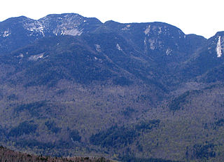
Nippletop is a mountain located in Essex County, New York. The mountain is part of the Colvin Range. Nippletop is flanked to the northeast by Dial Mountain. To the east, it faces Dix Mountain across Hunters Pass, and to the west it faces Mount Colvin across Elk Pass.
Macomb Mountain is a mountain located in Essex County, New York. The mountain is named after Maj. Gen. Alexander Macomb (1782–1841), who won acclaim during the War of 1812 at the Battle of Plattsburgh, and served as Commanding General of the United States Army (1828–1841).
Armstrong Mountain is a mountain located in Essex County, New York, named after Thomas Armstrong, a local pioneer. The mountain is part of the Great Range of the Adirondack Mountains. Armstrong Mtn. is flanked to the southwest by Gothics, and to the northeast by Upper Wolfjaw Mountain.
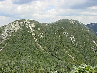
Saddleback Mountain is a mountain located in Essex County, New York. The mountain is part of the Great Range of the Adirondack Mountains. The 0.2 mi (0.32 km) long summit ridge has peaks at each end with a pronounced dip between, giving it the profile of a saddle. Saddleback Mtn. is flanked to the southwest by Basin Mountain, and to the east by Gothics.

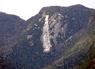
Sawteeth is a mountain located in Essex County, New York. The mountain is part of the Great Range of the Adirondack Mountains. The mountain's name comes from the serrated appearance of its summit ridge. Sawteeth is on a spur ridge of the Great Range, which branches off to the southeast from Gothics.

Lower Wolfjaw Mountain is located in Essex County, New York. Landscape artist Alexander Helwig Wyant (1836–1892) named Lower Wolfjaw, together with neighboring Upper Wolfjaw Mountain, about 1870 for their appearance in profile. The mountain is the northeasternmost of the Adirondack High Peaks in the Great Range of the Adirondack Mountains. Lower Wolfjaw Mountain is flanked to the southwest by Upper Wolfjaw Mountain, and to the northeast by Hedgehog Mountain.
Upper Wolfjaw Mountain is a mountain located in Essex County, New York. Landscape artist Alexander Helwig Wyant (1836–1892) named the mountain, in combination with neighboring Lower Wolfjaw Mountain, c. 1870 for their appearance in profile. The mountain is part of the Great Range of the Adirondack Mountains. Upper Wolfjaw Mtn. is flanked to the southwest by Armstrong Mountain, and to the northeast by Lower Wolfjaw Mtn.
Mount Marshall is a mountain located in Essex County, New York. Originally named for Governor DeWitt Clinton, and then for Herbert Clark, it was renamed for wilderness activist Bob Marshall (1901–1939) after his death. Marshall is part of the MacIntyre Mountains. Mount Marshall is flanked to the northeast by Iroquois Peak, and faces Wallface Mountain to the northwest across Indian Pass.

The Buckskin Mountains, of Arizona, are a mountain range in west-central Arizona, USA. The range lies just east of the north-south Colorado River, and borders south of the east-west, west-flowing Bill Williams River.

The Sevier Desert is a large arid section of central-west Utah, United States, and is located in the southeast of the Great Basin. It is bordered by deserts north, west, and south; its east border is along the mountain range and valley sequences at the perimeter of the Great Basin, with the large north-south Wasatch Range and its associated mountainous landforms. Its eastern border is specifically, the East Tintic, Gilson, and Canyon Mountains; also the massive Pavant Range.

Dun Brook Mountain is a mountain located in Adirondack Mountains of New York located in the town of Indian Lake east-northeast of Blue Mountain Lake. Tirrell Mountain is located west and Tirrel Pond is located west-southwest of Dun Brook Mountain.
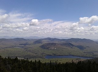
Tirrel Pond is a lake located northeast of the Hamlet of Blue Mountain Lake, New York. Tirrell Mountain is located northeast and Blue Mountain is located west-southwest of the lake.


