
The Sayan Mountains are a mountain range in southern Siberia, Russia and northern Mongolia. In the past, it served as the border between Mongolia and Russia.

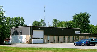
Indian Lake is a town in Hamilton County, New York, United States. The population was 1,352 at the 2010 census. The name is from a lake of the same name that is largely inside the town. There are no permanent stop lights in the town. Law enforcement is provided by New York State Troopers and Hamilton County Sheriff's Office.

Bolton is a town in Warren County, New York, United States. It is part of the Glens Falls Metropolitan Statistical Area. The population was 2,117 at the 2000 census. Bolton is on the east border of the county.

Burnaby is a city in British Columbia, Canada, part of Metro Vancouver and immediately to the east of the City of Vancouver. It is the third-largest city in British Columbia by population, surpassed only by Vancouver and nearby Surrey. Burnaby was incorporated in 1892 and achieved its City status in 1992, 100 years after incorporation. It is the seat of Metro Vancouver's regional government.

The Tongue River is a tributary of the Yellowstone River, approximately 265 mi (426 km) long, in the U.S. states of Wyoming and Montana. The Tongue rises in Wyoming in the Big Horn Mountains, flows through northern Wyoming and southeastern Montana and empties into the Yellowstone River at Miles City, Montana. Most of the course of the river is through the beautiful and varied landscapes of eastern Montana, including the Tongue River Canyon, the Tongue River breaks, the pine hills of southern Montana, and the buttes and grasslands that were formerly the home of vast migratory herds of American bison. The Tongue River watershed encompasses parts of the Cheyenne and Crow Reservations. The Headwaters lie on the Big Horn National Forest, and the watershed encompasses the Ashland Ranger District of the Custer National Forest.

The Bighorn Mountains are a mountain range in northern Wyoming and southern Montana in the United States, forming a northwest-trending spur from the Rocky Mountains extending approximately 200 miles (320 km) northward on the Great Plains. They are separated from the Absaroka Range, which lie on the main branch of the Rockies in western Wyoming, by the Bighorn Basin. Much of the land is contained within the Bighorn National Forest.

Chipewyan, ethnonym Dëne Sųłıné YatıéIPA: [tènɛ̀sũ̀ɬìnɛ́jàtʰìɛ́], is the language spoken by the Chipewyan people of northwestern Canada. It is categorized as part of the Northern Athabaskan language family. Dënësųłinë́ has nearly 12,000 speakers in Canada, mostly in Saskatchewan, Alberta, Manitoba and the Northwest Territories. It has official status only in the Northwest Territories, alongside 8 other aboriginal languages: Cree, Tlicho, Gwich'in, Inuktitut, Inuinnaqtun, Inuvialuktun, North Slavey and South Slavey.

Pazardzhik Province is a province in Southern Bulgaria, named after its administrative and industrial centre - the city of Pazardzhik. The territory is 4,456.9 km2 (1,720.8 sq mi) that is divided into 12 municipalities with a total population of 275,548 inhabitants, as of February 2011.

Passu is a small village located in the Gilgit Baltistan region of northern Pakistan. Situated along the Karakoram Highway in Upper Hunza, Passu is a popular tourist destination because of its easily accessible sweeping landscapes, and vistas of the 7,478 m tall Passu Sar mountain, the Passu Glacier, and Tupopdan 6,106m.

Lake George, nicknamed the Queen of American Lakes, is a long, narrow oligotrophic lake located at the southeast base of the Adirondack Mountains, in the northeastern portion of the U.S. state of New York. It lies within the upper region of the Great Appalachian Valley and drains all the way northward into Lake Champlain and the St. Lawrence River drainage basin. The lake is situated along the historical natural (Amerindian) path between the valleys of the Hudson and St. Lawrence Rivers, and so lies on the direct land route between Albany, New York and Montreal, Quebec, Canada. The lake extends about 32.2 mi (51.8 km) on a north-south axis, is 187 ft (57 m) deep, and varies from one to three miles in width, presenting a significant barrier to east-west travel. Although the year-round population of the Lake George region is relatively small, the summertime population can swell to over 50,000 residents, many in the village of Lake George region at the southern end of the lake.

Gostivar, is a city in North Macedonia, located in the upper Polog valley region. It is one of the largest municipalities in the country with a population of 81,042, and the town also covers 1.341 square kilometres. Gostivar has road and railway connections with the other cities in the region, such as Tetovo, Skopje, Kičevo, Ohrid, and Debar. A freeway was built in 1995, from Gostivar to Tetovo, 24 km (15 mi) long. Gostivar is the seat of Gostivar Municipality.

Saint-Donat is a township municipality in the Canadian province of Quebec, part of the Regional County Municipality of Matawinie, within the larger administrative region of Lanaudière. The main town within the township is also identified as Saint-Donat-de-Montcalm to distinguish it from a parish municipality with the same name in La Mitis RCM. It is located approximately 135 kilometres (84 mi) northwest of Montreal. The town is surrounded by mountains and numerous water basins of the Laurentian Mountains. The nearest natural landmark is the Mont-Tremblant National Park.
Rideau Lakes is a township located within Leeds and Grenville United Counties in Eastern Ontario, Canada. The township was incorporated on 1 January 1998 by amalgamating the former townships of North Crosby, South Crosby, Bastard, South Burgess and South Elmsley with the village of Newboro.

Rawdon is a municipality located on the Ouareau River in southwestern Quebec, Canada, about 60 kilometres north of Montreal. It is the seat for the Regional County Municipality of Matawinie, in the Lanaudière region. Rawdon is part of the Joliette federal electoral district.

The Tongue Mountain Range Trails are a series of hiking trails located within the Tongue Mountain Range, a subordinate range within the Adirondack Mountains of New York. The trails, 25 miles (40 km) in total length, vary from easy walks along the foot of the mountains on the shore of adjacent Lake George, to more rugged ascents of mountain peaks within the range.
The Garfield Range is a mountain range on Ellesmere Island, Nunavut, Canada. The mountains are made of Paleozoic rocks and rise to heights between 1,067 m (3,501 ft) and 1,433 m (4,701 ft) and are separated by valleys through which flow the major rivers fed by the ice fields and glaciers. Like most of the mountain ranges in the Arctic, it is one of the world's northernmost mountain ranges.

Pointe-Calumet is a municipality in the Canadian province of Quebec. The municipality is located within the Deux-Montagnes Regional County Municipality in the Laurentides region. It is situated about 30 minutes northwest of Montreal. Its population as of the 2006 Canadian Census is just over 6 000.

Callumayo is a river in the Andes of Peru located in the Arequipa Region, Caylloma Province, Lari District. It is a right tributary of the Colca River.
An alpentor in geology is the point where an entire glacier forced its way through to the Alpine Foreland from the Alps during the ice age.
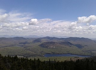
Tirrell Mountain is a mountain located in Adirondack Mountains of New York located in the Town of Indian Lake east-northeast of Blue Mountain Lake. Tirrel Pond is located southeast, Dun Brook Mountain is located east, and Tongue Mountain is located northeast of Tirrell Mountain.

