
Washington County is a regional economic, educational, and cultural hub in the Northwest Arkansas region. Created as Arkansas's 17th county on November 30, 1848, Washington County has 13 incorporated municipalities, including Fayetteville, the county seat, and Springdale. The county is also the site of small towns, bedroom communities, and unincorporated places. The county is named for George Washington, the first President of the United States.
Lincoln High School is a public secondary school in Lincoln, Arkansas, United States. Lincoln is one of ten public high schools in Washington County, Arkansas and is the only high school administered by the Lincoln Consolidated School District.
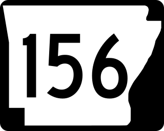
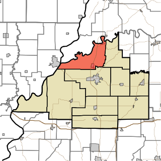
Highway 156 is a designation for three east–west state highways in Washington County, Arkansas. The first segment was created in 1937, with two more created in 1973. All are minor state highways established to provide system connectivity and are maintained by the Arkansas Department of Transportation (ArDOT).

Highway 244 is a designation for two state highways in Northwest Arkansas. Both segments are low volume, two-lane roadways in rural areas. The first segment was created in 1961, with the second designated in 1973 and extended through 1975. Both segments are maintained by the Arkansas Department of Transportation (ArDOT).
White River Township is one of ten townships in Gibson County, Indiana. As of the 2020 census, its population was 1,472 and it contained 723 housing units.

Knight Township is one of eight townships in Vanderburgh County, Indiana, United States. As of the 2010 census, its population was 67,945 and it contained 33,472 housing units. Knight Township has the largest township population in Southwestern Indiana and is the home of nearly 40 percent of Vanderburgh County's population. On October 1, 2009, the City of Evansville officially annexed territory within Knight Township bounded between Burkhardt Road, the Lloyd Expressway and Morgan Avenue.
Odell is an unincorporated community in Boston Township in southwestern Washington County, Arkansas, United States. The community is one mile north of the county line and the north boundary of the Ozark–St. Francis National Forest. Evansville is four miles west-northwest on Arkansas Highway 59 adjacent to the Arkansas - Oklahoma state line.

Clyde is an unincorporated community in Cane Hill Township, Washington County, Arkansas, United States. Clyde is on Arkansas Highway 45, approximately 26 miles southwest of Fayetteville and six miles east of the Oklahoma border.
Sexton is a former community in Dutch Mills Township, Washington County, Arkansas, United States. The community was located on a tributary of the Baron Fork approximately one-half mile east of the Arkansas - Oklahoma state line.

Evansville is an unincorporated community and census-designated place (CDP) in southwest Washington County, Arkansas, United States. It was first listed as a CDP in the 2020 census with a population of 102.
Hubbard is an unincorporated community in Valley Township, Washington County, Arkansas, United States. It is located near the intersection of Washington County Road 21 and Hubbard Road.
Morrow is an unincorporated community and census-designated place (CDP) in Washington County, Arkansas, United States. A post office has been in operation at Morrow since 1883; The community had the name of G. W. Morrow, an early postmaster. it was first listed as a CDP in the 2020 census with a population of 263;
Wesley is an unincorporated community and census-designated place (CDP) in western Madison County, Arkansas, United States. Wesley is located at the junction of Arkansas highways 74 and 295, 13 miles (21 km) by road west-southwest of Huntsville. Wesley has a post office with ZIP code 72773. It was first listed as a CDP in the 2020 census with a population of 161.
Blewford was a community in Harmon Township, Washington County, Arkansas, United States. It is located within the Ozark National Forest approximately one quarter mile east of Litteral Road and the Benton County line. US Route 412 is approximately one mile to the north.
Viney Grove is an unincorporated community in Marrs Hill Township, Washington County, Arkansas, United States. It is located north of Prairie Grove and Prairie Grove Battlefield State Park along County Road 37.
Hazel Valley is an unincorporated community in Reed Township, Washington County, Arkansas, United States. It is located along County Route 47 northeast of Winslow.
Rhea is an unincorporated community in Rhea's Mill Township, Washington County, Arkansas, United States. It is located on a county road north of Lincoln and Lincoln Lake. Weddington Mountain is just to the west.
Sulphur City is an unincorporated community in White River Township, Washington County, Arkansas, United States. It is located at the intersection of Black Oak Road and Whitehouse Road (CR 43). The community is on the east bank of the Middle Fork of the White River. The community of Black Oak lies approximately 1.5 miles to the northwest on the opposite side of the river.
Sunset is an unincorporated community in Reed Township, Washington County, Arkansas, United States. It is located at the intersection of Sunset Road and CR 110.
Suttle is an unincorporated community in Starr Hill Township, in western Washington County, Arkansas, United States. It is located on Washington County Road 33 and on the east bank of Moores Creek. Lincoln lies about two miles to the southwest.


