Tower of Set

Last updated
Tower of Set
Tonto-trail.jpg
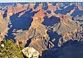
Southeast aspect, from Tonto Trail
Highest point
Elevation 6,012 ft (1,832 m) [1]
Prominence 432 ft (132 m) [1]
Parent peak Horus Temple (6,150 ft) [1]
Isolation 1.16 mi (1.87 km) [1]
Coordinates 36°07′16″N112°10′41″W / 36.1211306°N 112.1780426°W / 36.1211306; -112.1780426 Coordinates: 36°07′16″N112°10′41″W / 36.1211306°N 112.1780426°W / 36.1211306; -112.1780426 [2]
Geography
USA Arizona relief location map.svg
Red triangle with thick white border.svg
Tower of Set
Location in Arizona
Usa edcp relief location map.png
Red triangle with thick white border.svg
Tower of Set
Tower of Set (the United States)
Location Grand Canyon
Coconino County, Arizona, US
Parent range Kaibab Plateau
Colorado Plateau
Topo map USGS Grand Canyon
Geology
Type of rock sandstone, siltstone, mudstone
Climbing
First ascent 1977
Easiest route class 5.1 climbing [1]

Tower of Set is a 6,012-foot-elevation (1,832-meter) summit located in the Grand Canyon, in Coconino County of Arizona, US. [2] This butte is situated four miles north of Hopi Point overlook on the canyon's South Rim, two miles southeast of Tower of Ra, and three miles south-southwest of Shiva Temple, where it towers 3,600 feet (1,100 meters) above the Colorado River. Tower of Set was originally named Temple of Sett in 1879 by Thomas Moran, for the Egyptian deity of war, Set, because a niche worn into its wall evoked temples in the valley of the Nile. [2] [3] Another source states it was named by George Wharton James, in keeping with Clarence Dutton's tradition of naming geographical features in the Grand Canyon after mythological deities. [4] This mountain's name was officially adopted in 1906 by the U.S. Board on Geographic Names. [2] In 1919, Harriet Williams Russell Strong proposed connecting Hopi Point and Tower of Set across the river via an aerial tramway, an idea that never came to fruition. [4] [5] The first ascent was made in November 1977 by Bruce Grubbs and Jim Haggart. According to the Köppen climate classification system, Tower of Set is located in a cold semi-arid climate zone. [6]

Contents

Geology

The top of Tower of Set is composed of the reddish Pennsylvanian-Permian Supai Group. [7] Further down are strata of Mississippian Redwall Limestone, the Cambrian Tonto Group, and finally granite of the Paleoproterozoic Vishnu Basement Rocks at river level. Precipitation runoff from Tower of Set drains due-south to the Colorado River via Trinity Creek (east), and Ninetyfour Mile Creek (west).

See also

Related Research Articles

<span class="mw-page-title-main">Isis Temple</span> Landform in the Grand Canyon, Arizona

Isis Temple is a prominence in the Grand Canyon, Arizona, Southwestern United States. It is located below the North Rim and adjacent to the Granite Gorge along the Colorado River. The Trinity Creek and canyon flow due south at its west border; its north, and northeast border/flank is formed by Phantom Creek and canyon, a west tributary of Bright Angel Creek; the creeks intersect about 3 mi (4.8 km) southeast, and 1.0 mi (1.6 km) north of Granite Gorge. The Isis Temple prominence, is only about 202 ft (62 m) lower than Grand Canyon Village, the main public center on Grand Canyon’s South Rim.

<span class="mw-page-title-main">Zoroaster Temple</span> Landform in Coconino County, Arizona

Zoroaster Temple is a 7,123-foot-elevation (2,171-meter) summit located in the Grand Canyon, in Coconino County of Arizona, USA. It is situated 5.5 miles (8.9 km) northeast of the Yavapai Point overlook on the canyon's South Rim, from which it can be seen towering over 4,600 feet above the Colorado River and Granite Gorge. Its nearest higher neighbor is Brahma Temple, less than one mile to the north-northeast. Zoroaster Temple is named for Zoroaster, an ancient Iranian prophet. This name was used by George Wharton James and Clarence Dutton. Dutton began the tradition of naming geographical features in the Grand Canyon after mythological deities. This geographical feature's name was officially adopted in 1906 by the U.S. Board on Geographic Names.

<span class="mw-page-title-main">Brahma Temple (Grand Canyon)</span> Landform in the Grand Canyon, Arizona

Brahma Temple is a 7,551-foot-elevation summit located in the Grand Canyon, in Coconino County of Arizona, US. It is situated six miles (9.7 km) north-northeast of the Yavapai Point overlook on the canyon's South Rim, and 4.5 miles south of the North Rim's Bright Angel Point. It towers 5,000 feet above Phantom Ranch in Bright Angel Canyon. Its nearest higher neighbor is Oza Butte, four miles to the north-northwest. Other neighbors include Zoroaster Temple one mile to the south, and Deva Temple, 1.5 miles to the north. Brahma Temple is named for Brahma, the Hindu creator of the universe. This name was applied by Clarence Dutton who began the tradition of naming geographical features in the Grand Canyon after mythological deities. This geographical feature's name was officially adopted in 1906 by the U.S. Board on Geographic Names.

<span class="mw-page-title-main">Vishnu Temple (Grand Canyon)</span> Landform in the Grand Canyon, Arizona

Vishnu Temple is a 7,533-foot-elevation (2,296-meter) summit located in the Grand Canyon, in Coconino County of Arizona, US.

<span class="mw-page-title-main">Wotans Throne</span> Landform in the Grand Canyon, Arizona

Wotans Throne is a 7,721-foot-elevation (2,353-meter) summit located in the Grand Canyon, in Coconino County of Arizona, US. It is situated one mile immediately southwest of the Cape Royal overlook on the canyon's North Rim, 1.7 mile west-southwest of Freya Castle, two miles west-northwest of Vishnu Temple, and five miles east of Zoroaster Temple. It rises 5,200 feet above the Colorado River.

<span class="mw-page-title-main">Shiva Temple (Grand Canyon)</span> Landform in the Grand Canyon, Arizona

Shiva Temple is a 7,646-foot-elevation (2,331-meter) summit located in the Grand Canyon, in Coconino County of Arizona, US. It is situated six miles north of Hopi Point overlook of the canyon's South Rim, about 2.5 miles southwest of North Rim's Tiyo Point, and two miles northwest of Isis Temple, where it towers 5,200 feet above the Colorado River. Shiva Temple is named for Shiva, the Hindu deity, destroyer of the universe. This name was applied by Clarence Dutton who began the tradition of naming geographical features in the Grand Canyon after mythological deities. Dutton believed Shiva Temple was the largest, grandest, and most majestic of the Grand Canyon buttes, with a broad, level, forested top. This mountain's name was officially adopted in 1906 by the U.S. Board on Geographic Names.

<span class="mw-page-title-main">Tower of Ra</span> Landform in the Grand Canyon, Arizona

Tower of Ra is a 6,129-foot-elevation (1,868-meter) pillar located in the Grand Canyon, in Coconino County of Arizona, US. Its summit is situated five miles north of Pima Point overlook on the canyon's South Rim, three miles southeast of Confucius Temple, and two miles northwest of Tower of Set, where it towers over 3,700 feet above the Colorado River. Tower of Ra was named in 1879 by Thomas Moran, for Ra, the Egyptian deity of the sun. This followed the naming convention of Clarence Dutton who began the tradition of naming geographical features in the Grand Canyon after mythological deities. This mountain's name was officially adopted in 1906 by the U.S. Board on Geographic Names. The first ascent was made in 1977 by Jim Haggart, Art Christiansen, and Barbara Zinn. According to the Köppen climate classification system, Tower of Ra is located in a cold semi-arid climate zone.

<span class="mw-page-title-main">Buddha Temple (Grand Canyon)</span> Landform in the Grand Canyon, Arizona

Buddha Temple is a 7,212-foot-elevation (2,198-meter) summit located in the Grand Canyon, in Coconino County of northern Arizona, in the Southwestern United States. It is situated 6.5 miles (10.5 km) due north of the Mather Point overlook on the canyon's South Rim, and four miles southwest of the North Rim's Bright Angel Point. Topographic relief is significant as it rises over 3,800 feet in two miles above Bright Angel Canyon to the east, and 3,000 feet in less than one mile above Haunted Canyon to the immediate west. Its neighbors include Manu Temple 1.5 miles (2.4 km) to the northeast, Isis Temple 2.3 miles to the southwest, Zoroaster Temple 3.8 miles to the southeast, and Deva Temple, 3.5 miles to the east. Buddha Temple was named by Henry Gannett, a geographer for Clarence Dutton, in following Dutton's practice of naming features in the Grand Canyon after mythological deities, in this case Buddha. This geographical feature's name was officially adopted in 1906 by the U.S. Board on Geographic Names. The first ascent of this butte was made in 1973 by Bruce Grubbs, Chauncey Parker, and Mark Brown via the Northwest Arete. According to the Köppen climate classification system, Buddha Temple is located in a Cold semi-arid climate zone.

<span class="mw-page-title-main">Deva Temple</span> Landform in the Grand Canyon, Arizona

Deva Temple is a 7,353-foot-elevation (2,241-meter) summit located in the Grand Canyon, in Coconino County of northern Arizona, USA. It is situated three miles south of the North Rim's Bright Angel Point, and towers 3,700 feet above Bright Angel Canyon. Its nearest higher neighbor is Brahma Temple, 1.5 mile to the south. Other neighbors include Zoroaster Temple 2.5 miles to the south-southwest, Manu Temple three miles to the west-northwest, and Buddha Temple, 3.5 miles to the west. Deva Temple was named by Henry Gannett, a geographer for Clarence Dutton, in following Dutton's practice of naming features in the Grand Canyon after mythological deities, in this case, Deva. This geographical feature's name was officially adopted in 1906 by the U.S. Board on Geographic Names. According to the Köppen climate classification system, Deva Temple is located in a Cold semi-arid climate zone.

<span class="mw-page-title-main">Apollo Temple</span> Landform in the Grand Canyon, Arizona

Apollo Temple is a 6,252-foot-elevation (1,906-meter) summit located in the Grand Canyon, in Coconino County of northern Arizona, US. It is situated four miles due east of Cape Royal on the canyon's North Rim, four miles northeast of Vishnu Temple, and a half-mile south-southeast of Venus Temple, which is the nearest higher neighbor. Topographic relief is significant as it rises over 3,600 feet above the Colorado River in less than two miles.

<span class="mw-page-title-main">Osiris Temple</span> Landform in the Grand Canyon, Arizona

Osiris Temple is a 6,613 ft elevation summit located in the Grand Canyon, in Coconino County of Arizona, US. This butte is situated approximately (2.27 mi) southwest of Shiva Temple, in the Upper Trinity Creek watershed, a north watershed into the Colorado River at Granite Gorge.

Osiris Temple is the highest prominence in a series of three connected landforms extending south to Granite Gorge, namely Osiris Temple, Horus Temple, and Tower of Set. The western flanks of the landforms drain into regions of Lower Ninetyfour Mile Creek & Canyon; the eastern flanks drainage is into Trinity Canyon. The headwaters of Trinity Canyon is the southern flank of Shiva Temple, the parent landform of Osiris Temple. The Shiva Temple is a heavily forested tableland-butte, one of two such remnants of the North Rim. The other tableland is Wotans Throne, adjacent Cape Royal viewpoint.

<span class="mw-page-title-main">Confucius Temple (Grand Canyon)</span> Landform in the Grand Canyon, Arizona

Confucius Temple is a 7,081-foot-elevation (2,158-meter) summit located in the Grand Canyon, in Coconino County of northern Arizona, US. It is situated 1.5 mile southeast of Point Sublime, four miles west-northwest of Shiva Temple, and three miles northwest of Tower of Ra, where it rises over 3,200 feet above Hindu Amphitheater. Confucius Temple is named for Confucius, the Chinese philosopher. This name was applied by Clarence Dutton, who began the tradition of naming geographical features in the Grand Canyon after mythological deities. Confucius Temple is one of the Twin Buttes in the Grand Canyon, the other being Mencius Temple (7,001 ft), which is named for Mencius, considered the second-most famous sage, after only Confucius himself. This mountain's name was officially adopted in 1906 by the U.S. Board on Geographic Names. According to the Köppen climate classification system, Confucius Temple has a Cold semi-arid climate.

<span class="mw-page-title-main">Jupiter Temple</span> Landform in the Grand Canyon, Arizona

Jupiter Temple is a 7,084-foot (2,159 m)-elevation summit located in the Grand Canyon, in Coconino County of northern Arizona, United States. It is situated one mile (1.6 km) southeast of Cape Final on the canyon's North Rim, one point five miles (2.4 km) north-northwest of Apollo Temple, and three miles (4.8 km) northeast of Freya Castle, which is the nearest higher peak. Topographic relief is significant as it rises 4,400 feet (1,300 m) above the Colorado River in less than four miles (6.4 km).

<span class="mw-page-title-main">Pollux Temple</span> Landform in the Grand Canyon, Arizona

Pollux Temple is a 6,251-foot-elevation (1,905-meter) summit in the Grand Canyon, in Coconino County of northern Arizona, US. It is situated ten miles northwest of Grand Canyon Village, and less than one mile northeast of Jicarilla Point. Castor Temple is one mile northwest, and Diana Temple is one mile southeast. Topographic relief is significant as Pollux Temple rises nearly 4,000 feet above the Colorado River in less than two miles. Pollux Temple is named for Pollux, the divine son of Zeus according to Greek mythology. Clarence Dutton began the practice of naming geographical features in the Grand Canyon after mythological deities. According to the Köppen climate classification system, Pollux Temple is located in a Cold semi-arid climate zone.

<span class="mw-page-title-main">Marsh Butte</span> Landform in the Grand Canyon, Arizona

Marsh Butte is a 4,721-foot-elevation (1,439-meter) summit located in the Grand Canyon, in Coconino County in the northern part of the U.S. state of Arizona. It is situated eight miles northwest of Grand Canyon Village, immediately east-northeast of Diana Temple, and Tower of Ra stands directly opposite across Granite Gorge. Topographic relief is significant, as Marsh Butte rises over 2,300 feet above the Colorado River in half a mile (1 km).

<span class="mw-page-title-main">Cheops Pyramid</span> Landform in the Grand Canyon, Arizona

Cheops Pyramid is a 5,401-foot-elevation (1,646-meter) summit located in the Grand Canyon, in Coconino County of Arizona, US. This butte is situated four miles north of Grand Canyon Village, 2.5 miles south-southwest of Buddha Temple, and 1.7 mile south-southeast of Isis Temple, which is the nearest higher neighbor. Topographic relief is significant as it rises 3,000 feet above the Colorado River in 1.5 mile. It was named by George Wharton James for the fanciful resemblance to the famous pyramid constructed by Egyptian Pharaoh Cheops. This was in keeping with Clarence Dutton's tradition of naming geographical features in the Grand Canyon after mythological deities. This butte's name was officially adopted in 1906 by the U.S. Board on Geographic Names. According to the Köppen climate classification system, Cheops Pyramid is located in a Cold semi-arid climate zone.

<span class="mw-page-title-main">Vesta Temple</span> Landform in the Grand Canyon, Arizona

Vesta Temple is a 6,299-foot-elevation (1,920-meter) summit located in the Grand Canyon, in Coconino County of northern Arizona, US. It is situated eight miles west-northwest of Grand Canyon Village, and immediately northeast of Mimbreno Point. Marsh Butte is one mile northeast, Eremita Mesa immediately southeast, and nearest higher neighbor Diana Temple is one mile north. Topographic relief is significant as Vesta Temple rises 3,900 feet above the Colorado River in 2.5 miles. Vesta Temple is named for Vesta, the goddess of the hearth, home, and family according to Roman mythology. Clarence Dutton began the practice of naming geographical features in the Grand Canyon after mythological deities. This geographical feature's name was officially adopted in 1908 by the U.S. Board on Geographic Names. According to the Köppen climate classification system, Vesta Temple is located in a Cold semi-arid climate zone.

<span class="mw-page-title-main">King Arthur Castle</span> Landform in the Grand Canyon, Arizona

King Arthur Castle is a 7,344-foot-elevation (2,238-meter) summit located in the Grand Canyon, in Coconino County of northern Arizona, US. It is situated one-half mile northwest of Guinevere Castle, one mile west of Excalibur, and two miles east-southeast of Holy Grail Temple, within the Shinumo Amphitheater. Topographic relief is significant as it rises over 5,100 feet above the Colorado River in 4.5 miles (7.2 km). According to the Köppen climate classification system, King Arthur Castle is located in a cold semi-arid climate zone, with precipitation runoff draining west to the Colorado River via Shinumo Creek.

<span class="mw-page-title-main">Masonic Temple (Grand Canyon)</span> Landform in the Grand Canyon, Arizona

Masonic Temple is a 6,242-foot-elevation (1,903-meter) summit located in the Grand Canyon, in Coconino County of northern Arizona, US. Set below Dutton Point on the Powell Plateau, and overlooking the Shinumo Amphitheater, it is situated three miles west of Holy Grail Temple, 2.7 miles northwest of Dox Castle, and 1.6 miles north-northeast of Fan Island. Topographic relief is significant as it rises 4,000 feet above the Colorado River in four miles (6.4 km). According to the Köppen climate classification system, Masonic Temple is located in a cold semi-arid climate zone, with precipitation runoff draining south to the Colorado River via Hakatai Canyon from the west aspect, Burro Canyon from the south aspect, and Muav Canyon from the east aspect. This butte is an erosional remnant composed of strata of the Pennsylvanian-Permian Supai Group overlaying the conspicuous cliffs of Mississippian Redwall Limestone, in turn overlaying the Cambrian Tonto Group.

<span class="mw-page-title-main">Grand Scenic Divide</span> Landform in the Grand Canyon, Arizona

Grand Scenic Divide is a 5,667-foot-elevation (1,727-meter) ridge located in the Grand Canyon, in Coconino County of northern Arizona, Southwestern United States. It is situated immediately north of Fossil Mountain, and 1.5 mile east of Mount Huethawali. Surrounded by Bass and Serpentine Canyons, topographic relief is significant as it rises over 3,400 feet above the nearby Colorado River in 1.5 mile. It is composed of strata of the Pennsylvanian-Permian Supai Group. Further down are strata of the cliff-forming Mississippian Redwall Limestone, and Cambrian Tonto Group. According to the Köppen climate classification system, Grand Scenic Divide is located in a cold semi-arid climate zone. The normal approach to the ridge is made via the South Bass Trail, and from the top the view includes Masonic Temple, Holy Grail Temple, Dox Castle, King Arthur Castle, Evans Butte, Sagittarius Ridge, and Scorpion Ridge.

References

  1. 1 2 3 4 5 "Tower of Set – 6,012' AZ". Lists of John. Retrieved December 23, 2020.
  2. 1 2 3 4 "Tower of Set". Geographic Names Information System . United States Geological Survey, United States Department of the Interior . Retrieved 2020-12-23.
  3. Gregory McNamee, Grand Canyon Place Names, 1997, Mountaineers Publisher, ISBN   9780898865332, page 110.
  4. 1 2 Randy Moore and Kara Felicia Witt, The Grand Canyon: An Encyclopedia of Geography, History, and Culture, 2018, ABC-CLIO Publisher, page 211.
  5. Fodor's Arizona & the Grand Canyon, 2007, ISBN   9781400017065, page 145.
  6. Peel, M. C.; Finlayson, B. L.; McMahon, T. A. (2007). "Updated world map of the Köppen−Geiger climate classification". Hydrol. Earth Syst. Sci. 11 (5): 1633. Bibcode:2007HESS...11.1633P. doi:10.5194/hess-11-1633-2007. ISSN   1027-5606. S2CID   9654551.
  7. N.H. Darton, Story of the Grand Canyon of Arizona, 1917, pages 12, 37.