Typhoon Nanmadol,known in the Philippines as Super Typhoon Yoyong,[1] was the last of four consecutive tropical cyclones to strike the Philippines in 2004. A quickly moving system,Nanmadol brought heavy rainfall and strong winds over the same regions impacted by the previous storms,exacerbating flood conditions in Luzon and surrounding regions. Together Nanmadol and these systems accounted for around 1,000deaths in the Philippines. The typhoon later became the first December tropical cyclone to strike Taiwan since record keeping began,bringing along with it heavy rain,which also affected nearby regions of eastern China. As an extratropical storm,Nanmadol brought gusty winds and rain to Japan. The name Nanmadol was contributed by Micronesia and refers to the Nan Madol archaeological site on Pohnpei.
Nanmadol developed from an isolated area of convection south-southwest of Pohnpei that became classified as a tropical depression on November28. Within highly conducive conditions for development,the system reached tropical storm intensity the following day,followed by typhoon intensity on November30. Quickly pacing towards the north-northwest about the periphery of a nearby subtropical ridge,Nanmadol reached its peak intensity on December1 with winds of 165km/h (103mph) and a minimum barometric pressure of 935mbar (hPa;27.61inHg).[nb 1] Shortly after,the typhoon made landfall at a similar intensity on Casiguran,Aurora,quickly moving over Luzon before reaching the South China Sea,where it recurved northward into hostile atmospheric conditions. Over the next few days,Nanmadol weakened and later transitioned into an extratropical cyclone near Taiwan on December4,whereafter it merged with another extratropical system.
With the typhoon approaching landfall in an area still recovering from previous storms,relief agencies already servicing the region were forced to allocate additional resources to prepare for Nanmadol. Evacuation efforts assisted in moving almost 100,000people into shelters. Effects from Nanmadol were most severe in Cagayan Valley,where 14people were killed. Power outages were widespread across several islands. Overall,damage from the typhoon in the Philippines totaled ₱2.23billion (US$39.3million).[nb 2][nb 3] Heavy rainfall,peaking at 1,090mm (43in),was documented in Taiwan. Agricultural damage in Taiwan alone reached NT$670million (US$20.8million). Similar effects were felt in Japan,where the remnants of Nanmadol produced record-breaking rainfall and wind. Damage was particularly significant in Aichi Prefecture,totaling JP¥69.8 million (US$680,000). Overall,Nanmadol resulted in 77fatalities and US$60.8million in damage across three countries.
Meteorological history
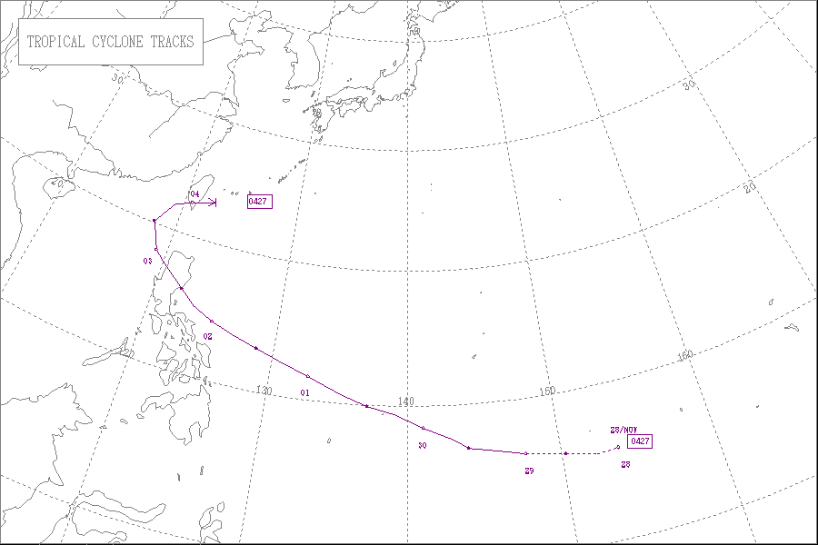
Map plotting the storm's track and intensity,according to the Saffir–Simpson scale
The progenitor to Typhoon Nanmadol was first noted by the Joint Typhoon Warning Center(JTWC) as an isolated cluster of thunderstorms roughly 290km (180mi) south-southwest of Pohnpei at 2200UTC on November27, 2004. With convection consolidating about a potential center of circulation,[1] the Japan Meteorological Agency(JMA) classified the broad system as a tropical depression the following day.[2] Rapid development of storms and organization ensued following classification, spurred by favorable conditions. Tracking northwestward due to the presence of a nearby subtropical ridge to its north,[1] the depression continued to strengthen, reaching tropical storm intensity on November29 while 860km (530mi) south-southeast of Guam.[2][3] At this point the tropical cyclone was assigned the name Nanmadol.[1]
Conducive atmospheric conditions around Nanmadol on November29 led to the development of a central dense overcast, followed shortly thereafter by the formation of an eye.[1] Nanmadol was upgraded to severe tropical storm intensity at 0000UTC on November30 and became a typhoon twelve hours later,[2] tracking near Satawal, Woleai, and Yap State during this intensification phase.[1] Following the upgrade to typhoon status, intensification briefly slowed but continued soon thereafter. At 0600UTC on December1, Nanmadol reached peak intensity with maximum sustained winds of 165km/h (103mph) and a minimum barometric pressure of 935mbar (hPa; 27.61inHg), still east of the Philippines. The typhoon maintained this strength for roughly twelve hours before slightly weakening as it neared Luzon.[2] At approximately 1200UTC on December2,[1] Nanmadol made landfall near Casiguran, Aurora with winds of 140km/h (87mph).[4]
Due to the rapid motion of Nanmadol, the typhoon crossed Luzon in under six hours, emerging into the South China Sea before 1800UTC on December2.[2] Though land interaction with the Philippines did not significantly affect the cyclone, a shortwave trough forced Nanmadol to sharply curve northward, bringing it into hostile atmospheric conditions within the Luzon Strait.[4] At 0000UTC on December3, the JMA downgraded Nanmadol to severe tropical storm status.[2] Increased wind shear and the advection of dry air further weakened the tropical cyclone, and by midday on December3, the storm's center of circulation became decoupled from the rest of the convection.[1] At 2340UTC that day, Nanmadol made landfall near Fangliao, Pingtung in Taiwan, becoming the first December tropical cyclone to strike the island in 108years of record-keeping.[1][2] Roughly six hours later on December4, the JMA determined that Nanmadol had transitioned into an extratropical cyclone.[2] These remnants soon merged with another low-pressure area, creating a more powerful system that later tracked over Japan.[1]
Preparations
Typhoon Nanmadol approaching the Philippines on December2
Initial forecasts following the formation of Nanmadol over open waters anticipated the typhoon to track directly into Luzon.[1] On December1, government sessions in Manila were temporarily suspended. Some commercial flights traversing to and from Luzon were cancelled in addition to ferry service between the eastern Bicol Region and Manila, stranding hundreds of passengers.[5] Flight cancellations were primarily targeted at propeller aircraft as they were more susceptible to typhoon conditions.[6] This impacted ongoing relief efforts, as the Philippine Air Force's fleet of rescue planes were also grounded.[7] The impending storm also delayed the reopening of financial markets in Manila until December3.[8]
Animation of PSWS History throughout the passage of TY Yoyong (Nanmadol)
President Gloria Macapagal Arroyo ordered for precautionary measures to be undertaken by agencies under the purview of the National Disaster Coordinating Council(NDCC).[9] In response, the German Foreign Office allocated €50,000 (US$67,000) to assist in preparations for Nanmadol.[10] The Spanish Red Cross were forced to maintain relief supplies in the provinces of Aurora and Quezon in addition to managing ongoing relief efforts for regions impacted by Tropical Depression Winnie.[11] Individual Red Cross chapters were tasked with closely monitoring the movement of relief stockpiles during these preparatory measures.[12]
The NDCC also called for the evacuation of persons in potentially affected areas.[5] Large-scale evacuations took place in Real, Quezon ahead of the approaching typhoon.[13] According to the NDCC, 97,238persons were evacuated in the lead-up to Nanmadol's Luzon landfall, with nearly 40,000 evacuating from the Bicol Region.[14] However, the Office of Civil Defense documented the evacuation of approximately 168,000civilians.[6] Government shelters initially made to house displaced residents due to previous storms were adjusted to accommodate additional refugees evacuating due to the typhoon.[15] In Catanduanes, 1,500persons evacuated to these shelters.[16] Other evacuees sought refuge in well-constructed buildings, as was the case in Mercedes, Eastern Samar, where 2,000civilians stayed inside a school.[6]
In Taiwan, the Central Weather Bureau issued a land warning for the island in advance of the typhoon. Potential impacts, which would likely be enhanced by the East Asian Monsoon, prompted Taiwanese president Chen Shui-bian to postpone political marches and campaign rallies intended for the upcoming presidential elections.[17] In anticipation for the typhoon, schools and businesses in southern and eastern Taiwan were closed, along with the delaying of rail and air traffic. Kaohsiung International Airport was closed during the morning of December4.[18]
Because of differing sources, totals may not match.[19]
Satellite image showing flooding in the Philippines after Nanmadol on December4
Damage assessments of Nanmadol's impacts in the Philippines found difficulty in distinguishing the storm's impacts from those of Typhoon Muifa, Tropical Storm Merbok, and Tropical Depression Winnie due to their rapid succession of effects. The NDCC, however, noted 70fatalities as a result of Nanmadol alone, coupled with 157injuries.[1] The majority of deaths were associated with electrocutions or drownings.[20] Approximately 160,000people were displaced as well.[17] Overall, the typhoon destroyed 10,457households and damaged another 57,435.[1] Damage was estimated at ₱2.23billion (US$39.3million).[19] Precipitation peaked at 228mm (9.0in) in Daet, Camarines Norte, observed over a 24-hour period.[1]
Even prior to the Philippine landfall of Nanmadol, ongoing relief operations were hampered by the storm's overreaching effects. Search and rescue helicopters failed to reach planned destinations, which was also due in part to the country's small helicopter fleet. A navy gunboat refitted as a relief ship headed for Real, Quezon was forced to turn back due to high waves onset by the approaching typhoon which swept potentially hazardous logs into sea.[6][21]
The first Philippine provinces to be impacted by the typhoon were Albay and Catanduanes, which suffered power outages after strong winds tore down power lines.[22][23] One person was killed in Virac, Catanduanes after being electrocuted by a felled power line.[24] In order to prevent more widespread outages, electrical service in some locations was deliberately shut down. Landslides triggered by Nanmadol in Aurora killed 25people.[25] On the Bicol Peninsula, eight fatalities occurred due to drowning, electrocution, or hypothermia.[26]
In the aftermath of the typhoon, the Philippine Red Cross made a full emergency appeal for funding to assist in recovery from Nanmadol and preceding storms.[27] The Philippines government declared a state of calamity for fifteen provinces, cities, and municipalities. Medical personnel were deployed to mitigate potential outbreaks of disease and transport injured persons to hospitals. The NDCC distributed 14,065sacks of rice worth roughly ₱11million (US$200,000).[19]
Elsewhere
On 4 December 2004, the Nanmadol turned into an extratropical cyclone, and the Central Weather Bureau, Taiwan lifted the typhoon warning
Shortly before transitioning into an extratropical cyclone, Nanmadol made landfall in Fangliao, Taiwan as a tropical storm. This made Nanmadol the first recorded tropical cyclone to strike Taiwan in the month of December since records began in 1896. Heavy precipitation associated with the typhoon was reported, peaking at 1,090mm (43in) in Pulowan. The highest documented 24-hour rainfall total was at a station in Hualien County, which recorded 907mm (35.7in) in that timeframe.[1] Power outages disrupted electrical supply to 26,588households, and agricultural losses in Taiwan as a result of Nanmadol equated to NT$670million (US$20.8million). Two people were killed on the island. The typhoon's swath of rainfall also extended to East China, which was also climatologically abnormal. Rainfall in Fuzhou peaked at 52.3mm (2.06in), almost double the average for the month of December. In Zhejiang, rainfall peaked at 106mm (4.2in).[1]
The extratropical remnants of Nanmadol brought record breaking rainfall and winds to Japan. A station in Shishikui, Tokushima received 269mm (10.6in) of rain, the highest amount documented in the country. Several other stations recorded rainfall totals in excess of 200mm (7.9in). Maximum sustained winds clocked at 88km/h (55mph) in Chiba, Chiba and Ojima, Tokyo, were the strongest ever recorded in December for those locations. The same station in Chiba clocked a wind gust at 176km/h (109mph), another record for the month of December and the highest reported wind gust in Japan from Nanmadol's remnants. A 145km/h (90mph) wind gust was recorded in Tokyo; this gust broke the record for the strongest gust recorded in the city since record-keeping began.[1] Offshore Kagoshima Prefecture, a ferry capsized in rough waters, killing five.[28] The captain of the ferry was later charged with professional negligence.[29] In Aomori Prefecture, widespread power outages resulted from the strong winds.[30] Heavy rains in Aichi Prefecture flooded several roads and damaged fisheries and agricultural land. One person was injured there, and damage totaled JP¥69.8million (US$680,000).[31]
↑Hong Kong Observatory (June 2005). Tropical Cyclones In 2004(PDF) (Report). Kowloon, Hong Kong. p.30. Retrieved June 2, 2014.
12Atangan, J.F.; Preble, Amanda; United States Naval Maritime Forecast Center (2004). Vancas, Michael (ed.). 2004 Annual Tropical Cyclone Report(PDF). Joint Typhoon Warning Center Annual Tropical Cyclone Reports (Report). Pearl Harbor, Hawaii: Joint Typhoon Warning Center. pp.163–4. Archived from the original(PDF) on December 6, 2013. Retrieved August 31, 2013.
↑"Typhoon Nanmadol hits the eastern Philippines". Real, Philippines. Agence France-Pesse. December 2, 2004.
↑"Roundup: Typhoon Nanmadol kills at least 35 in Philippines". Manila, Philippines. Deutsche Presse-Agentur. December 3, 2004.
↑"Typhoon leaves trail of destruction as Philippines buries its dead". Real, Philippines. Agence France-Pesse. December 3, 2004.
↑"Red Cross launches appeal for Philippine flood victims". Geneva, Switzerland. Agence France-Pesse. December 3, 2004.
↑Kitamoto Asanobu. "Weather Disaster Report (2004-827-37)". Digital Typhoon (in Japanese). Tokyo, Japan: National Institute of Informatics. Retrieved June 6, 2014.
↑"Japanese boat captain arrested after five go overboard in typhoon". Tokyo, Japan. Agence France-Pesse. December 6, 2004.
↑Kitamoto Asanobu. "Weather Disaster Report (2004-575-13)". Digital Typhoon (in Japanese). Tokyo, Japan: National Institute of Informatics. Retrieved June 6, 2014.
↑Kitamoto Asanobu. "Weather Disaster Report (2004-636-18)". Digital Typhoon (in Japanese). Tokyo, Japan: National Institute of Informatics. Retrieved June 6, 2014.
This page is based on this Wikipedia article Text is available under the CC BY-SA 4.0 license; additional terms may apply. Images, videos and audio are available under their respective licenses.


