The City of Idaho Springs is the statutory city that is the most populous municipality in Clear Creek County, Colorado, United States. Idaho Springs is a part of the Denver–Aurora–Lakewood, CO Metropolitan Statistical Area. As of the 2020 census it had a population of 1,782. Idaho Springs is located in Clear Creek Canyon, in the mountains upstream from Golden, some 30 miles (50 km) west of Denver.

Golden is a home rule city that is the county seat of Jefferson County, Colorado, United States. The city population was 20,399 at the 2020 United States Census. Golden lies along Clear Creek at the base of the Front Range of the Rocky Mountains. Founded during the Pike's Peak Gold Rush on June 16, 1859, the mining camp was originally named Golden City in honor of Thomas L. Golden. Golden City served as the capital of the provisional Territory of Jefferson from 1860 to 1861, and capital of the official Territory of Colorado from 1862 to 1867. In 1867, the territorial capital was moved about 12 miles (19 km) east to Denver City. Golden is now a part of the Denver–Aurora–Lakewood, CO Metropolitan Statistical Area and the Front Range Urban Corridor.
Gold Hill is an unincorporated community and a census-designated place (CDP) located in and governed by Boulder County, Colorado, United States. The CDP is a part of the Boulder, CO Metropolitan Statistical Area. The population of the Gold Hill CDP was 218 at the United States Census 2020. The Boulder post office serves the area.

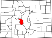
Georgetown is the territorial charter municipality that is the county seat of Clear Creek County, Colorado, United States. The town population was 1,118 at the 2020 United States Census. The former silver mining camp along Clear Creek in the Front Range of the Rocky Mountains was established in 1859 during the Pike's Peak Gold Rush. The federally designated Georgetown-Silver Plume Historic District comprises Georgetown, the neighboring town of Silver Plume, and the Georgetown Loop Historic Mining & Railroad Park between the two towns. The Georgetown Post Office has the ZIP code 80444.

Pack burro racing is a sport in Colorado, Arizona, California, and New Mexico that is rooted in the various western states' mining histories. In the early days of the mining industry in Colorado, miners would take donkeys through the mountains of Colorado while prospecting. Because the burros were carrying supplies, the miners could not ride the animals and so they would walk, leading the donkey. Burro races are held throughout small towns in Colorado, Arizona, California, and New Mexico to commemorate the miners and their burros. In 2012, pack burro racing was recognized as the official "summer heritage sport" in Colorado.

Kentucky Camp is a ghost town and former mining camp along the Arizona Trail in Pima County, Arizona, United States, near the community of Sonoita. The Kentucky Camp Historic District is listed on the National Register of Historic Places and has been since 1995. As it is located within Coronado National Forest, the United States Forest Service is responsible for the upkeep of the remaining buildings within the Kentucky Camp Historic District.

Granite is an unincorporated community with a U.S. Post Office in Chaffee County, Colorado, United States. The zip code of Granite is 81228. According to the 2010 census, the population is 116.

The Georgetown–Silver Plume National Historic Landmark District is a federally designated United States National Historic Landmark that comprises the Town of Georgetown, the Town of Silver Plume, and the Georgetown Loop Historic Mining & Railroad Park between the two silver mining towns along Clear Creek in the Front Range of the Rocky Mountains in Clear Creek County, Colorado, United States.

Mogollon, also called the Mogollon Historic District, is a former mining town located in the Mogollon Mountains in Catron County, New Mexico, United States. Located east of Glenwood and Alma, it was founded in the 1880s at the bottom of Silver Creek Canyon to support the gold and silver mines in the surrounding mountains. The "Little Fannie" mine became the most important employer for the town. During the 1890s, Mogollon had a transient population of between 3,000 and 6,000 miners. Because of its isolation, it had a reputation as one of the wildest mining towns in the West. Today Mogollon is listed as Fannie Hill Mill and Company Town Historic District on the National Register of Historic Places.

Chalk Creek is a 27.3-mile-long (43.9 km) river flowing east from the Collegiate Peaks mountain range in Chaffee County, Colorado. Mount Antero borders the southern side of the river, while Mount Princeton borders the northern side. The headwaters of the river are located at the Continental Divide. The river empties into the Arkansas River at the town of Nathrop, Colorado.

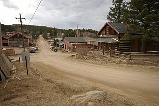
Saint Elmo is a ghost town in Chaffee County, Colorado, United States. Founded in 1880, Saint Elmo lies in the heart of the Sawatch Range, 20 miles (32 km) southwest of Buena Vista and sits at an elevation of 9,961 feet (3,036 m). Nearly 2,000 people settled in this town when mining for gold and silver started. The mining industry started to decline in the early 1920s, and in 1922 the railroad discontinued service. The community is listed on the National Register of Historic Places as the Saint Elmo Historic District. It is one of Colorado's best preserved ghost towns.

This is an alphabetical list of articles related to the U.S. State of Colorado.
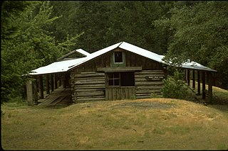
The Whisky Creek Cabin is a rustic log cabin located in southwest Oregon along the section of the Rogue River that is designated as a National Wild and Scenic River. It is the oldest remaining mining cabin in the Rogue River canyon. The Bureau of Land Management purchased the cabin and surrounding property in 1973. The Whisky Creek Cabin is listed on the National Register of Historic Places in 1975.

The Osceola Ditch, also known as the East Ditch, was built in 1889–1890 to convey water from Lehman Creek, Nevada to a hydraulic mine operation at Osceola. Extending for 18 mi (29 km), the ditch includes a 600 ft (180 m) tunnel as well as wooden flumes. The project also includes a rock dam and headgate on Stella Lake. The ditch's terminus at Osceola, Nevada became disused during the early 1900s and was destroyed entirely by a fire in the 1940s. Much of the East Ditch is included within Great Basin National Park.
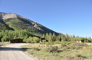
Winfield is a ghost town in Chaffee County, Colorado, United States. It is estimated that as many as 1,500 people may have lived in Winfield.

Reading's Bar is a historical site in Redding, California in Shasta County. Reading's Bar is a California Historical Landmark No. 32 listed on August 1, 1932. Reading's Bar was named after Major Pierson Barton Reading, who discovered gold on the Clear Creek bar in May 1848, starting a California Gold Rush in the surrounding area. Later he found gold on a sandbar on the Trinity River that started the Trinity Alps Gold Rush. Reading's gold discovery was a major part of the California Gold Rush and news of the find created a rush of gold prospecting in Northern California, well north of the better-known gold fields of the Sierra Nevada foothills.

Horsetown was a major historical mining town on the Clear Creek in Reading, California in Shasta County. The town was founded as a tent mining town in 1851 after Major Pierson Barton Reading found gold just east of where the town was founded. Reading's gold find site is called Reading's Bar after the sandbar on Clear Creek. The small mining town was first called Clear Creek Diggings in 1851, it was founded on Clear Creek Road and Clear Creek. As the town grew it was given the name One Horse Town and then it was changed to Horsetown. The gold found here starting a California Gold Rush in the surrounding area.

Tower House, California was mining town in Shasta County. The mining District of Tower House was placed on the National Register of Historic Places on July 2, 1973, as #73000257 as the Tower House Historic District. The Tower House Historic District is located just west of the Whiskeytown National Recreation Area. The town started as a California Gold Rush camp. The town is named after Levi Tower, who built the Tower House Hotel and helped establish the town.