Viking, Minnesota

Last updated

Viking, Minnesota
Viking Diner and Antiques Viking, Minnesota 3-17-2006.jpg
Viking Diner and Antiques in Viking
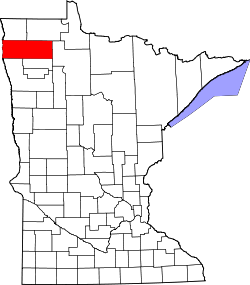
Marshall County Minnesota Incorporated and Unincorporated areas Viking Highlighted.svg
Location of Viking, Minnesota
Coordinates: 48°13′12″N96°24′24″W / 48.22000°N 96.40667°W / 48.22000; -96.40667
CountryUnited States
State Minnesota
County Marshall
Organized1884
Incorporated April 12, 1921
Government
   Mayor Michael Hestekind
Area
[1]
  Total0.516 sq mi (1.335 km2)
  Land0.516 sq mi (1.335 km2)
  Water0.000 sq mi (0.000 km2)
Elevation
[2]
1,070 ft (326 m)
Population
 (2020) [3]
  Total79
  Estimate 
(2022) [4]
79
  Density153.10/sq mi (59.17/km2)
Time zone UTC–6 (Central (CST))
  Summer (DST) UTC–5 (CDT)
ZIP Code
56760
Area code 218
FIPS code 27-67090
GNIS feature ID0653655 [2]
Sales tax 6.875% [5]

Viking is a city in Marshall County, Minnesota, United States. The population was 79 at the 2020 census. [3]

Contents

History

A post office called Viking has been in operation since 1890. [6] The city was organized in 1884, and was named by Rev. Hans P. Hansen, a Norwegian Lutheran pastor in Warren, after the Vikings. [7]

Geography

According to the United States Census Bureau, the city has a total area of 0.516 square miles (1.34 km2), all land. [1]

Demographics

Historical population
CensusPop.Note
1930 133
1940 1469.8%
1950 130−11.0%
1960 128−1.5%
1970 118−7.8%
1980 1299.3%
1990 103−20.2%
2000 92−10.7%
2010 10413.0%
2020 79−24.0%
2022 (est.)79 [4] 0.0%
U.S. Decennial Census [8]
2020 Census [3]

2010 census

As of the 2010 census, there were 104 people, 43 households, and 31 families living in the city. The population density was 203.9 inhabitants per square mile (78.7/km2). There were 46 housing units at an average density of 90.2 per square mile (34.8/km2). The racial makeup of the city was 96.2% White and 3.8% from two or more races. Hispanic or Latino of any race were 1.9% of the population.

There were 43 households, of which 37.2% had children under the age of 18 living with them, 48.8% were married couples living together, 20.9% had a female householder with no husband present, 2.3% had a male householder with no wife present, and 27.9% were non-families. 25.6% of all households were made up of individuals, and 4.7% had someone living alone who was 65 years of age or older. The average household size was 2.42 and the average family size was 2.81.

The median age in the city was 42 years. 30.8% of residents were under the age of 18; 1.9% were between the ages of 18 and 24; 23% were from 25 to 44; 28.8% were from 45 to 64; and 15.4% were 65 years of age or older. The gender makeup of the city was 43.3% male and 56.7% female.

2000 census

As of the 2000 census, there were 92 people, 39 households, and 26 families living in the city. The population density was 180.3 inhabitants per square mile (69.6/km2). There were 44 housing units at an average density of 86.2 per square mile (33.3/km2). The racial makeup of the city was 100.00% White. Hispanic or Latino of any race were 1.09% of the population.

There were 39 households, out of which 28.2% had children under the age of 18 living with them, 59.0% were married couples living together, 7.7% had a female householder with no husband present, and 30.8% were non-families. 30.8% of all households were made up of individuals, and 17.9% had someone living alone who was 65 years of age or older. The average household size was 2.36 and the average family size was 2.96.

In the city, the population was spread out, with 28.3% under the age of 18, 4.3% from 18 to 24, 22.8% from 25 to 44, 21.7% from 45 to 64, and 22.8% who were 65 years of age or older. The median age was 42 years. For every 100 females, there were 87.8 males. For every 100 females age 18 and over, there were 100.0 males.

The median income for a household in the city was $28,750, and the median income for a family was $36,250. Males had a median income of $36,250 versus $26,250 for females. The per capita income for the city was $11,812. There were 7.7% of families and 14.3% of the population living below the poverty line, including 21.2% of under eighteens and none of those over 64.

Related Research Articles

<span class="mw-page-title-main">Frederika, Iowa</span> City in Iowa, United States

Frederika is a city in Bremer County, Iowa, United States. The population was 204 at the time of the 2020 census. It is named for Fredrika Bremer, the Swedish author, for whom the surrounding county was also named.

Summit Township is a township in Beltrami County, Minnesota, United States. The population was 259 as of the 2000 census.

<span class="mw-page-title-main">Pine River, Minnesota</span> City in Minnesota, United States

Pine River is a city in Cass County, Minnesota, United States. The population was 911 at the 2020 census. It is part of the Brainerd Micropolitan Statistical Area.

<span class="mw-page-title-main">Garrison, Minnesota</span> City in Minnesota, United States

Garrison is a city in Crow Wing County, Minnesota, United States, along Mille Lacs Lake. The population was 210 at the 2010 census. It is part of the Brainerd Micropolitan Statistical Area. U.S. Highway 169 and Minnesota State Highway 18 are the main routes in the community.

Lawrence Township is a township in Grant County, Minnesota, United States. The population was 96 at the 2000 census.

Clay Township is a township in Hubbard County, Minnesota, United States. The population was 49 at the 2000 census.

Rockwood Township is a township in Hubbard County, Minnesota, United States, not to be confused with Rockwood Township in Wadena County. The population was 469 at the 2000 census.

Grattan Township is a township in Itasca County, Minnesota, United States. The population was 44 at the 2010 census.

Cedar Township is a township in Marshall County, Minnesota, United States. The population was 94 at the 2000 census.

<span class="mw-page-title-main">Holt, Minnesota</span> City in Minnesota, United States

Holt is a city in Marshall County, Minnesota, United States. The population was 90 at the 2020 census.

Wright Township is a township in Marshall County, Minnesota, United States. The population was 126 at the 2000 census.

Maplewood Township is a township in Otter Tail County, Minnesota, United States. The population was 333 at the 2000 census.

<span class="mw-page-title-main">Trail, Minnesota</span> City in Minnesota, United States

Trail is a city in Polk County, Minnesota, United States. It is part of the Grand Forks, ND-MN Metropolitan Statistical Area. The population was 40 at the 2020 census.

Winger Township is a township in Polk County, Minnesota, United States. It is part of the Grand Forks-ND-MN Metropolitan Statistical Area. The population was 177 at the 2000 census.

<span class="mw-page-title-main">McKinley, St. Louis County, Minnesota</span> City in Minnesota, United States

McKinley is a city in Saint Louis County, Minnesota, United States; located within the Iron Range region of Minnesota. The population was 103 at the 2020 census.

<span class="mw-page-title-main">Dumont, Minnesota</span> City in Minnesota, United States

Dumont is a city in Traverse County, Minnesota, United States. The population was 75 at the 2020 census.

<span class="mw-page-title-main">Genola, Minnesota</span> City in Minnesota, United States

Genola is a city in Morrison County, Minnesota, United States. The population was 70 at the 2020 census.

Falun Township is a township in Roseau County, Minnesota, United States. The population was 226 at the 2000 census.

Davidson is an unorganized territory in Polk County, Minnesota, United States. The population was 42 at the 2010 census.

Clear Creek is an unorganized territory in Carlton County, Minnesota, United States, located near Holyoke. The population was 118 at the 2000 census.

References

  1. 1 2 "2023 U.S. Gazetteer Files". United States Census Bureau. Retrieved July 24, 2022.
  2. 1 2 U.S. Geological Survey Geographic Names Information System: Viking, Minnesota
  3. 1 2 3 "Explore Census Data". United States Census Bureau . Retrieved February 12, 2024.
  4. 1 2 "City and Town Population Totals: 2020-2022". United States Census Bureau. February 12, 2024. Retrieved February 12, 2024.
  5. "Viking (MN) sales tax rate" . Retrieved February 12, 2024.
  6. "Marshall County". Jim Forte Postal History. Retrieved July 13, 2015.
  7. Upham, Warren (1920). Minnesota Geographic Names: Their Origin and Historic Significance. Minnesota Historical Society. p.  330.
  8. "Census of Population and Housing". census.gov. Retrieved June 4, 2015.

48°13′07″N96°24′21″W / 48.21861°N 96.40583°W / 48.21861; -96.40583