
Madison County is a county located in the U.S. state of North Carolina. As of the 2010 census, the population was 20,764. Its county seat is Marshall.

Walnut Creek is a city in Contra Costa County, California, United States, located in the East Bay region of the San Francisco Bay Area, about 16 miles (26 km) east of the city of Oakland. With a total estimated population of 69,122, Walnut Creek serves as a hub for its neighboring cities because of its location at the junction of the highways from Sacramento and San Jose (I-680) and San Francisco/Oakland (SR-24) and its accessibility by BART. Its active downtown neighborhood features hundred-year-old buildings and extensive high-end retail establishments, restaurants and entertainment venues.

Walnut is a city in the eastern part of Los Angeles County in the U.S. state of California. Money's Best Places to Live ranked Walnut #70 in 2009 and #57 in 2011, the highest ranking for a California city in both years. As of the 2010 census, the city had a population of 29,172, and in 2018 the population was estimated at 30,006.

The Santa Monica Mountains is a coastal mountain range in Southern California, paralleling the Pacific Ocean. It is part of the Transverse Ranges. Because of its proximity to densely populated regions, it is one of the most visited natural areas in California. Santa Monica Mountains National Recreation Area is located in this mountain range.

The Pomona Valley is located in the Greater Los Angeles Area between the San Gabriel Valley and San Bernardino Valley in Southern California. The valley is approximately 30 miles east of downtown Los Angeles, which can often be seen from nearby foothills. It ranges from the city of San Dimas from the far west to Rancho Cucamonga to the Far East portion of the valley. The alluvial valley is formed by the Santa Ana River and its tributaries.
Walnut Hill station is a DART Light Rail station in Dallas, Texas. It serves DART's Red Line, and is located in North Dallas at Walnut Hill Lane and Manderville Lane, just east of US 75. It is the second of four elevated stations on the DART system, and it opened on 1 July 2002 and serves nearby residential and shopping areas of Lake Highlands, as well as Presbyterian Hospital of Dallas.

Chino Hills State Park is a state park of California, in the United States. It is located in the Chino Hills, foothills of the Santa Ana Mountains. It is a critical link in the Chino–Puente Hills wildlife corridor, and a major botanical habitat reserve for resident and migrating wildlife.
Walnut Hill School for the Arts is an independent boarding school for the arts located in Natick, Massachusetts, United States.

Tuyserkan is a city and capital of Tuyserkan County, Hamadan Province, Iran. At the 2016 census, its population was 50,455, in 16,291 families.

Walnut Hill is a neighborhood in the West Philadelphia section of Philadelphia, Pennsylvania. It is located between 45th Street and 52nd Street, bounded by Market Street and Spruce Street. Most of the neighborhood is in the northwestern part of the University City District. It is located north of the neighborhoods of Garden Court and Spruce Hill.
East Walnut Hills is a neighborhood on the Southeast side of Cincinnati, Ohio. The population was 3,794 at the 2010 census.

Walnut Street is located in downtown Philadelphia and extends from the city's Delaware River waterfront through Center City and West Philadelphia. Walnut Street has been characterized as "the city's premier shopping district". A portion of the street commonly called Rittenhouse Row was ranked 12th in 2005 by Women's Wear Daily among its list of the most expensive retail streets in North America, with rents of $90 per square foot, and is home to several "upscale dining, retail and cultural" establishments. In 2013 rents had risen to an average of $107 a foot, a growth of 34% over 2012 and the largest percentage growth of any retail corridor in the country.
Walnut Hill is a historic neighborhood located in north Omaha, Nebraska. It is bounded by North 40th Street on the east, Cuming Street on the south, Northwest Radial Highway and Saddle Creek Road on the west and Hamilton Street on the north.

The San Jose Hills are a part of the Transverse Ranges located in Eastern Los Angeles County, California, marking the border between the San Gabriel Valley and the Pomona Valley. It includes portions of Covina, West Covina, Walnut, Pomona, and San Dimas. To the south, the valley of San Jose Creek separates the San Jose Hills from the Puente Hills and Chino Hills.

Walnut Heights is an unincorporated community in Contra Costa County, California, United States. It is located at an elevation of 200 feet, in the hills near Walnut Creek. The ZIP Code is 94596. The community is inside area code 925. It is served by Walnut Heights Elementary School, Walnut Creek Intermediate, and Las Lomas High School.
Riverland/Walnut Hills is a Roanoke, Virginia neighborhood located in southeast Roanoke south of the Roanoke River. It borders the neighborhoods of South Jefferson and South Roanoke on the west, Morningside on the east and Mill Mountain on the south. The neighborhood is divided into the Walnut Hill area at the base of Mill Mountain, and the Riverland area along the Roanoke River, with Virginia State Route 116 running through the entire area. As of the 2000 U.S. Census, Riverland/Walnut Hills has a population of 1,033.
Morningside is a Roanoke, Virginia neighborhood located in east, central Roanoke, along the north bank of the Roanoke River. It borders the neighborhoods of South Jefferson and Riverland/Walnut Hills on the west, Kenwood and Riverdale on the east, Belmont on the north and both Garden City and Mill Mountain on the south. In being the location of the former American Viscose plant, the Morningside neighborhood exhibits both industrial characteristics as well as development patterns typical of those experienced for an American city during the early 20th century.

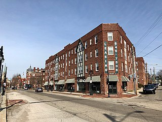
Walnut Hills is a neighborhood in Cincinnati, Ohio, United States. One of the city’s oldest hilltop neighborhoods, it is a large diverse area on the near east side of Cincinnati. Eden Park is the gateway to Walnut Hills when driving north from downtown, and the University of Cincinnati is less than 10 minutes away. The neighborhood is redeveloping, restoring many of its buildings and introducing new businesses to the area. The population was 6,495 at the 2010 census.

Hopper Mountain National Wildlife Refuge is located in the Topatopa Mountains of Ventura County, in southern California. It is bordered by the Los Padres National Forest and the Sespe Condor Sanctuary to the north. The 2,471-acre (10.00 km2) refuge was established in 1974 to protect the endangered California condor, its habitat, and other wildlife resources.

Chuck Hill is a mountain in Sullivan County, New York. It is located west-southwest of Liberty. Walnut Mountain is located southeast and Revonah Hill is located north-northeast of Chuck Hill.

