
Aberdeenshire is one of the 32 council areas of Scotland.

Kincardineshire or the County of Kincardine, also known as the Mearns, is a historic county, registration county and lieutenancy area on the coast of north-east Scotland. It is bounded by Aberdeenshire on the north, and by Angus on the south-west.

Grampian was one of nine local government regions of Scotland. It was created in 1975 by the Local Government (Scotland) Act 1973 and took its name from the Grampian Mountains. The regional council was based in Aberdeen.
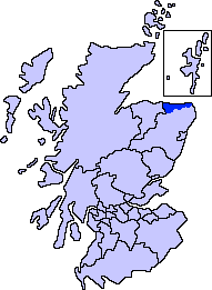
Banff and Buchan is a committee area of the Aberdeenshire Council, Scotland, covering an area along the northern coast of the council area. The main towns are Banff and Fraserburgh. Fishing and agriculture are important industries, together with associated processing and service activity.
Gordon was one of five local government districts in the Grampian region of Scotland. The council was based in Inverurie. It was created in 1975 and abolished in 1996, when the area was included in the Aberdeenshire council area.

Kincardine and Deeside was one of five local government districts in the Grampian region of Scotland. Its council was based in Stonehaven. It was created in 1975 and abolished in 1996, when the area was included in the Aberdeenshire council area.

Aberdeenshire or the County of Aberdeen is a historic county in Scotland. The county gives its name to the modern Aberdeenshire council area, which covers a larger area than the historic county. The historic county ceased to be used for local government purposes in 1975, but its boundaries are still used for certain functions, being a registration county. The area of the historic county excluding the Aberdeen City council area is also a lieutenancy area.

Aberdeen South is a burgh constituency of the House of Commons of the Parliament of the United Kingdom which elects one Member of Parliament (MP) by the first-past-the-post system of election.

Aberdeen North is a burgh constituency of the House of Commons of the Parliament of the United Kingdom and it elects one Member of Parliament (MP) by the first past the post system of election. It was first used in the 1885 general election, but has undergone various boundary changes since that date. The seat has been held by Kirsty Blackman of the Scottish National Party since 2015.

West Aberdeenshire and Kincardine is a county constituency of the House of Commons of the Parliament of the United Kingdom of Great Britain and Northern Ireland (Westminster), which elects one Member of Parliament (MP) by the first past the post system of election. It was first used in the 1997 general election, but has undergone boundary changes since that date. West Aberdeenshire and Kincardine was re-created as a parliamentary constituency in 1997, having previously existed as Kincardine and Western Aberdeenshire from 1918 to 1950.
Gordon was a county constituency of the House of Commons of the Parliament of the United Kingdom (Westminster), which elected one member of Parliament (MP) by the first past the post system of election. The constituency was first contested at the 1983 UK general election; and underwent boundary changes throughout its existence.
Elgin Burghs was a district of burghs constituency of the House of Commons of Great Britain from 1708 to 1801 and of the House of Commons of the United Kingdom from 1801 to 1918. Until 1832, when Peterhead was added, the constituency comprised the parliamentary burghs of Elgin, Cullen, Banff, Inverurie and Kintore, lying in Elginshire, Banffshire and Aberdeenshire.
Aberdeen and Kincardine Central, also known as Central Aberdeenshire, was a county constituency of the House of Commons of the Parliament of the United Kingdom from 1918 until 1950. It elected one Member of Parliament (MP) by the first past the post system of election.
EastAberdeenshire was a Scottish county constituency of the House of Commons of the Parliament of the United Kingdom from 1868 to 1918 and from 1950 to 1983. It elected one Member of Parliament (MP) by the first past the post system of election.
Kincardineshire was a constituency of the House of Commons of the Parliament of Great Britain from 1708 to 1801 and of the Parliament of the United Kingdom from 1801 to 1918. It was represented by one Member of Parliament (MP).

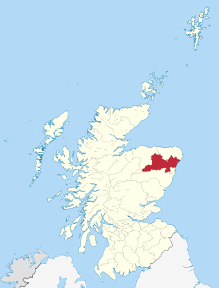
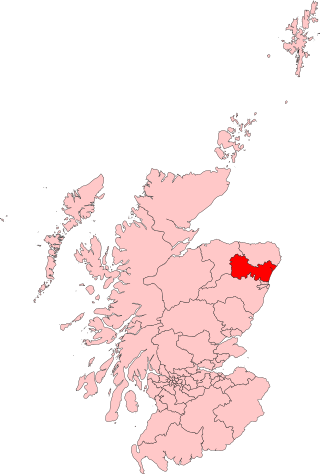
Garioch is one of six committee areas in Aberdeenshire, Scotland. It has a population of 46,254, which gives it the largest population of Aberdeenshire's six committee areas. The Garioch consists primarily of the district drained by the River Ury and its tributaries the Shevock and the Gadie Burn.

Scottish Westminster constituencies were Scottish constituencies of the House of Commons of the Parliament of Great Britain, normally at the Palace of Westminster, from 1708 to 1801, and have been constituencies of the House of Commons of the Parliament of the United Kingdom, also at Westminster, since 1801. Constituency boundaries have changed on various occasions, and are now subject to both periodical and ad hoc reviews of the Boundary Commission for Scotland.
WestPerthshire was a county constituency of the House of Commons of the Parliament of the United Kingdom from 1885 to 1918. It elected one Member of Parliament (MP) by the first-past-the-post voting system.

Aberdeenshire West is a constituency of the Scottish Parliament (Holyrood) covering part of the council area of Aberdeenshire. It elects one Member of the Scottish Parliament (MSP) by the first past the post method of election. Also, however, it is one of ten constituencies in the North East Scotland electoral region, which elects seven additional members, in addition to ten constituency MSPs, to produce a form of proportional representation for the region as a whole.
Aberdeen and Kincardine East was a county constituency of the House of Commons of the Parliament of the United Kingdom from 1918 to 1950. The constituency elected one Member of Parliament (MP) by the first past the post system of election.
