
A birch is a thin-leaved deciduous hardwood tree of the genus Betula, in the family Betulaceae, which also includes alders, hazels, and hornbeams. It is closely related to the beech-oak family Fagaceae. The genus Betula contains 30 to 60 known taxa of which 11 are on the IUCN 2011 Red List of Threatened Species. They are a typically rather short-lived pioneer species widespread in the Northern Hemisphere, particularly in northern areas of temperate climates and in boreal climates.

Indian Lake is a town in Hamilton County, New York, United States. The population was 1,352 at the 2010 census. The name is from a lake of the same name that is largely inside the town. There are no permanent stop lights in the town. Law enforcement is provided by New York State Troopers and Hamilton County Sheriff's Office.

Eagle Point is a town in Chippewa County in the U.S. state of Wisconsin. The population was 3,053 at the 2010 census. The unincorporated communities of Eagle Point and Eagleton are located in the town.

The Ojibwe, Ojibwa, Chippewa, or Saulteaux are an Anishinaabe people of Canada and the northern Midwestern United States. They are one of the most numerous indigenous peoples north of the Rio Grande. In Canada, they are the second-largest First Nations population, surpassed only by the Cree. In the United States, they have the fifth-largest population among Native American peoples, surpassed in number only by the Navajo, Cherokee, Choctaw and Sioux.
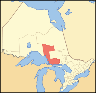
Algoma District is a district and census division in Northeastern Ontario in the Canadian province of Ontario.

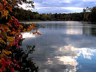
Lake Nipissing is a lake in the Canadian province of Ontario. It has a surface area of 873.3 km2 (337.2 sq mi), a mean elevation of 196 m (643 ft) above sea level, and is located between the Ottawa River and Georgian Bay. Lake Nipissing is the third-largest lake entirely in Ontario. It is relatively shallow for a large lake, with an average depth of only 4.5 m (15 ft). The shallowness of the lake makes for many sandbars along the lake's irregular shoreline. The lake reaches a maximum depth of 64 m near the mouth of the French River, off the shore of Blueberry Island. The lake has many islands most of which are protected under the Protection of Significant Wetlands scheme, controlled by the Ministry of Natural Resources and Forestry.

Parkland County is a municipal district in central Alberta, Canada. Located west of Edmonton in Census Division No. 11, its municipal office, Parkland County Centre, is located 0.25 km (0.16 mi) north of the Town of Stony Plain on Highway 779.

Kittatinny Mountain is a long ridge traversing across northwestern New Jersey running in a northeast-southwest axis, a continuation across the Delaware Water Gap of Pennsylvania's Blue Mountain Ridge. It is the first major ridge in the far northeastern extension of the Ridge and Valley province of the Appalachian Mountains, and reaches its highest elevation, 1,803 feet, at High Point in Montague Township. Kittatinny Mountain forms the eastern side of Wallpack Valley; the western side comprises the Wallpack Ridge (highest elevation: 928 feet above sea level.

Grand Portage State Park is a state park at the northeastern tip of Minnesota, USA, on the Canada–United States border. It contains a 120-foot (37 m) waterfall, the tallest in the state, on the Pigeon River. The High Falls and other waterfalls and rapids upstream necessitated a historically important portage on a fur trade route between the Great Lakes and inland Canada. This 8.5-mile (13.7 km) path plus the site of forts on either end are preserved in nearby Grand Portage National Monument. The state park, held by the surrounding Grand Portage Indian Reservation and leased to the state of Minnesota for $1 a year, is the only U.S. state park jointly managed by a state and a Native American band. It is also the only Minnesota state park not owned by the state.

Bear Head Lake State Park is a state park of Minnesota, United States, providing ready access to outdoor recreation in the Boundary Waters region. It boasts scenery similar to the nearby Boundary Waters Canoe Area Wilderness, with the added conveniences of road access, modern facilities, and motorboating. The most popular visitor activities are boating, fishing, swimming, and hiking. The park entirely surrounds 670-acre (270 ha) Bear Head Lake and three other fishing lakes. It was established in 1961 in Saint Louis County near Ely, Minnesota. The park also contains the woodlands surrounding the lakes, which gives an entire total of about 5,540 acres. The park also shares a large border with Bear Island State Forest.

The Sisseton Wahpeton Oyate of the Lake Traverse Reservation, formerly Sisseton-Wahpeton Sioux Tribe/Dakota Nation, is a federally recognized tribe comprising two bands and two subdivisions of the Isanti or Santee Dakota people. They are on the Lake Traverse Reservation in northeast South Dakota.
Big Ridge State Park is a state park in Union County, Tennessee, in the southeastern United States. The park consists of 3,687 acres (14.92 km2) on the southern shore of the Norris Reservoir, an impoundment of the Clinch River created by the completion of Norris Dam in 1936. Much of the park's recreational focus is on Big Ridge Lake, a 45-acre (0.18 km2) sub-impoundment of Norris near the center of the park.

Lake Wilcox is a kettle lake in the Oak Ridges neighbourhood of Richmond Hill, Ontario, Canada. The lake measures 1.5 kilometers across and covers 55.6 hectares or 0.55 square kilometres, making it the largest kettle lake on the Oak Ridges Moraine. Lake Wilcox, Lake St. George and their associated wetlands form a "provincially significant wetland".

Halcott Mountain is one of the Catskill Mountains of the U.S. state of New York. It is mostly located in Greene County, with some of its lower slopes in Delaware and Ulster counties. Its exact summit elevation has not been officially determined, but the highest contour line on the mountain is 3,520 feet (1,070 m). It is one of the peaks on the divide between the Delaware and Hudson watersheds.

Balsam Lake Mountain is one of the Catskill Mountains, located in the Town of Hardenburgh, New York, United States. It is the westernmost of the range's 35 High Peaks. Its exact height has not been determined, but the highest contour line on topographic maps, 3,720 feet (1,130 m), is usually given as its elevation.

Graham Mountain is the seventh highest of the Catskill High Peaks and the highest privately owned mountain in the range. It is located in the town of Hardenburgh, New York, United States.

Mountain Lake Wilderness is a U.S. Wilderness Area in the George Washington and Jefferson National Forests. The wilderness area is located next to privately owned Mountain Lake, and consists of 8,314 acres (3,365 ha) in Virginia and 2,721 acres (1,101 ha) in West Virginia.

The Northwest Angle State Forest is a state forest located in Lake of the Woods County, Minnesota. The name of the forest is derived from its location near the Northwest Angle, the northernmost point of the contiguous United States. The forest borders the Canadian provinces of Manitoba and Ontario, and the Red Lake Indian Reservation. The forest is managed by the Minnesota Department of Natural Resources.
The White Lake Wilderness Area is a wilderness area located in Nova Scotia, Canada, in Halifax Regional Municipality. Several trails, all owned by the Musquodoboit Trailways Association, pass through it; Gibraltar Rock Loop, White Lake Wilderness Trails, the Musquodoboit Rail Trail, the Bayers Lake Loop, and the Admiral Lake loop.
The Waverley - Salmon River Long Lake Wilderness Area is a provincial wilderness area located about 20 kilometers east of Dartmouth Nova Scotia, Canada.

