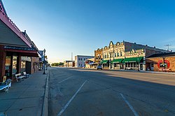
Wilber, Nebraska - Czech Capital of the United States, February 2013
Wilber was platted in 1873[4] by C. D. Wilber, and named for him.[5] In 1878, the seat of Saline County was transferred to Wilber from Pleasant Hill.[6]
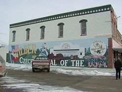
Wilber was declared the official Czech Capital of the United States on July 10, 1987, in a decree signed by president Ronald Reagan. Wilber hosts the annual Czech Days festival which celebrates the city's Czech heritage.
As of the census[10] of 2010, there were 1,855 people, 696 households, and 449 families living in the city. The population density was 2,061.1 inhabitants per square mile (795.8/km2). There were 782 housing units at an average density of 868.9 unitsper square mile (335.5 units/km2). The racial makeup of the city was 90.5% White, 1.8% African American, 0.6% Native American, 1.8% Asian, 0.4% Pacific Islander, 3.6% from other races, and 1.3% from two or more races. Hispanic or Latino of any race were 10.8% of the population.
There were 696 households, of which 34.9% had children under the age of 18 living with them, 51.6% were married couples living together, 8.9% had a female householder with no husband present, 4.0% had a male householder with no wife present, and 35.5% were non-families. 31.0% of all households were made up of individuals, and 14.4% had someone living alone who was 65 years of age or older. The average household size was 2.42 and the average family size was 3.01.
The median age in the city was 38.8 years. 25% of residents were under the age of 18; 6.4% were between the ages of 18 and 24; 27.9% were from 25 to 44; 23.2% were from 45 to 64; and 17.6% were 65 years of age or older. The gender makeup of the city was 49.6% male and 50.4% female.
2000 census
As of the census of 2000, there were 1,761 people, 728 households, and 457 families living in the city. The population density was 1,960.2 inhabitants per square mile (756.8/km2). There were 795 housing units at an average density of 884.9 unitsper square mile (341.7 units/km2). The racial makeup of the city was 97.33% White, 0.06% Native American, 0.85% Asian, 0.11% Pacific Islander, 1.14% from other races, and 0.51% from two or more races. Hispanic or Latino of any race were 1.82% of the population.
There were 728 households, out of which 32.6% had children under the age of 18 living with them, 50.8% were married couples living together, 8.2% had a female householder with no husband present, and 37.2% were non-families. 33.4% of all households were made up of individuals, and 17.6% had someone living alone who was 65 years of age or older. The average household size was 2.31 and the average family size was 2.97.
In the city, the population was spread out, with 25.7% under the age of 18, 7.2% from 18 to 24, 27.1% from 25 to 44, 17.7% from 45 to 64, and 22.3% who were 65 years of age or older. The median age was 38 years. For every 100 females, there were 87.3 males. For every 100 females age 18 and over, there were 83.1 males.
A mural in Wilber depicting "Czech Capital of the USA", December 2000
As of 2000 the median income for a household in the city was $36,513, and the median income for a family was $45,556. Males had a median income of $31,000 versus $21,824 for females. The per capita income for the city was $18,249. About 4.4% of families and 7.6% of the population were below the poverty line, including 8.3% of those under age 18 and 9.2% of those age 65 or over.
Notable people
Dana Altman, head men's basketball coach at the University of Oregon
C. L. Edson, newspaper columnist, humorist, and poet
This page is based on this Wikipedia article Text is available under the CC BY-SA 4.0 license; additional terms may apply. Images, videos and audio are available under their respective licenses.